The Cleveland Street station (formerly Cleveland Avenue station) is a skip-stop station on the BMT Jamaica Line of the New York City Subway in Brooklyn. It is served by the J train at all times. The Z train skips this station when it operates.
Cleveland Street | |||||||||||||||||||||||||||||||||||||||||||||||||||||||||||||||||||||||||||
|---|---|---|---|---|---|---|---|---|---|---|---|---|---|---|---|---|---|---|---|---|---|---|---|---|---|---|---|---|---|---|---|---|---|---|---|---|---|---|---|---|---|---|---|---|---|---|---|---|---|---|---|---|---|---|---|---|---|---|---|---|---|---|---|---|---|---|---|---|---|---|---|---|---|---|---|
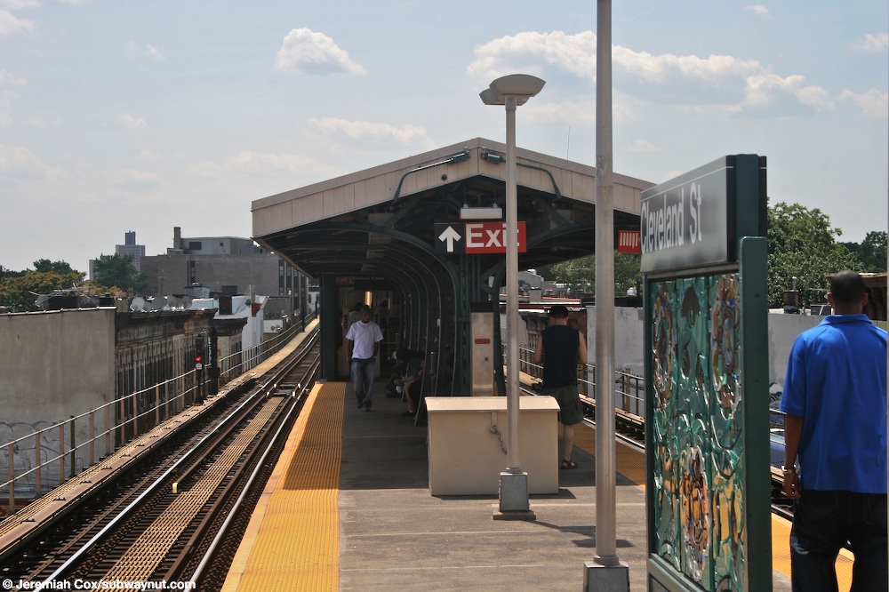
 The west end of the platform | |||||||||||||||||||||||||||||||||||||||||||||||||||||||||||||||||||||||||||
| Station statistics | |||||||||||||||||||||||||||||||||||||||||||||||||||||||||||||||||||||||||||
| Address | Cleveland Street & Fulton Street Brooklyn, NY 11208 | ||||||||||||||||||||||||||||||||||||||||||||||||||||||||||||||||||||||||||
| Borough | Brooklyn | ||||||||||||||||||||||||||||||||||||||||||||||||||||||||||||||||||||||||||
| Locale | Highland Park | ||||||||||||||||||||||||||||||||||||||||||||||||||||||||||||||||||||||||||
| Coordinates | 40°40′47″N 73°53′08″W / 40.679629°N 73.885589°W | ||||||||||||||||||||||||||||||||||||||||||||||||||||||||||||||||||||||||||
| Division | B (BMT)[1] | ||||||||||||||||||||||||||||||||||||||||||||||||||||||||||||||||||||||||||
| Line | BMT Jamaica Line BMT Lexington Avenue Line (formerly) | ||||||||||||||||||||||||||||||||||||||||||||||||||||||||||||||||||||||||||
| Services | J | ||||||||||||||||||||||||||||||||||||||||||||||||||||||||||||||||||||||||||
| Transit | |||||||||||||||||||||||||||||||||||||||||||||||||||||||||||||||||||||||||||
| Structure | Elevated | ||||||||||||||||||||||||||||||||||||||||||||||||||||||||||||||||||||||||||
| Platforms | 1 island platform | ||||||||||||||||||||||||||||||||||||||||||||||||||||||||||||||||||||||||||
| Tracks | 2 | ||||||||||||||||||||||||||||||||||||||||||||||||||||||||||||||||||||||||||
| Other information | |||||||||||||||||||||||||||||||||||||||||||||||||||||||||||||||||||||||||||
| Opened | May 30, 1893[2] | ||||||||||||||||||||||||||||||||||||||||||||||||||||||||||||||||||||||||||
| Opposite- direction transfer | Yes | ||||||||||||||||||||||||||||||||||||||||||||||||||||||||||||||||||||||||||
| Traffic | |||||||||||||||||||||||||||||||||||||||||||||||||||||||||||||||||||||||||||
| 2022 | 459,097[3] | ||||||||||||||||||||||||||||||||||||||||||||||||||||||||||||||||||||||||||
| Rank | 391 out of 423[3] | ||||||||||||||||||||||||||||||||||||||||||||||||||||||||||||||||||||||||||
| |||||||||||||||||||||||||||||||||||||||||||||||||||||||||||||||||||||||||||
| |||||||||||||||||||||||||||||||||||||||||||||||||||||||||||||||||||||||||||
| |||||||||||||||||||||||||||||||||||||||||||||||||||||||||||||||||||||||||||
| |||||||||||||||||||||||||||||||||||||||||||||||||||||||||||||||||||||||||||
| |||||||||||||||||||||||||||||||||||||||||||||||||||||||||||||||||||||||||||


History edit
This elevated station was originally built by the Brooklyn Elevated Railroad as the first station to be built along the Cypress Hills extension of the Lexington Avenue Elevated line, which was also shared by the Broadway Elevated east of Gates Avenue. The station opened on May 30, 1893.[2] The station has been exclusively for the Jamaica Line since the closure of the Lexington Avenue Line in 1950.
The station was closed for renovations in the mid-2000s. As part of the station renovation project, the stairs were rehabilitated, the floors were renewed, major structural repairs were made, new canopies were installed, the area around the station booth was reconfigured, the platform edge strips were replaced, walls were replaced, and a high-quality public address system was installed.[4] The renovation cost $8.41 million.[5]
Station layout edit
| P Platform level |
Westbound | ← ← |
| Island platform | ||
| Eastbound | | |
| M | Mezzanine | Fare control, station agent, MetroCard machines |
| G | Street level | Entrances/exits |
The station has two tracks and one island platform.[6] The canopy is located at the west end of the platform and is short and has arched supports.[7]
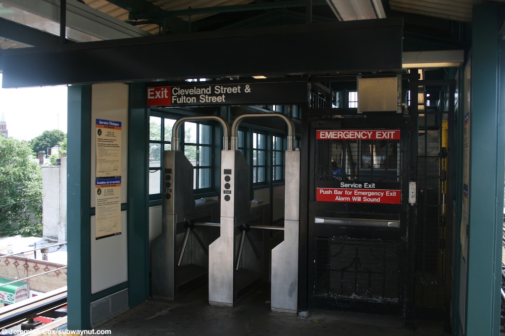
Exit edit
The station's only entrance and exit is a station house at the west end of the platform. It has a bank of two turnstiles, token booth,[8] and one staircase going down to an elevated passageway beneath the tracks. Outside of fare control, there are two stairs, one to each western corner of Fulton and Cleveland Streets.[9]
See also edit
References edit
- ^ "Glossary". Second Avenue Subway Supplemental Draft Environmental Impact Statement (SDEIS) (PDF). Vol. 1. Metropolitan Transportation Authority. March 4, 2003. pp. 1–2. Archived from the original (PDF) on February 26, 2021. Retrieved January 1, 2021.
- ^ a b "Trains Running This Morning". Brooklyn Daily Eagle. Brooklyn, NY. May 30, 1893. p. 10. Retrieved February 18, 2018.
- ^ "Annual Subway Ridership (2017–2022)". Metropolitan Transportation Authority. 2022. Retrieved November 8, 2023.
- ^ "MTA NYC Transit Subway Line Information". mta.info. Metropolitan Transportation Authority. December 21, 2005. Archived from the original on December 21, 2005. Retrieved October 2, 2016.
{{cite web}}: CS1 maint: bot: original URL status unknown (link) - ^ MTA 2006 Adopted Budget - February Financial Plan - Part 3 (PDF) (Report). Metropolitan Transportation Authority. 2006. p. 46. Archived from the original (PDF) on May 24, 2019. Retrieved March 27, 2020.
- ^ Dougherty, Peter (2006) [2002]. Tracks of the New York City Subway 2006 (3rd ed.). Dougherty. OCLC 49777633 – via Google Books.
- ^ Cox, Jeremiah (June 25, 2008). "Looking towards the canopied area of the platform at Cleveland Street by the station house that is attached at one end. The canopy coves maybe two cars". subwaynut.com. Retrieved January 31, 2019.
- ^ Cox, Jeremiah (June 25, 2008). "The very small and narrow fare control area at Cleveland St sow just how small the station's platform is". subwaynut.com. Retrieved January 31, 2019.
- ^ "Neighborhood Map: Cleveland St (J)" (PDF). mta.info. Metropolitan Transportation Authority. Retrieved November 18, 2018.
External links edit
- nycsubway.org – BMT Jamaica Line: Cleveland Street
- Station Reporter — J Train
- The Subway Nut — Cleveland Street Pictures Archived August 14, 2019, at the Wayback Machine
- MTA's Arts For Transit — Cleveland Street (BMT Jamaica Line)
- Cleveland Street entrance from Google Maps Street View
- Platform from Google Maps Street View