Cayambe is an agricultural service city (population 44,559 at the last census on October 1, 2022) in highland Ecuador. It lies at the foot of the Cayambe volcano. While the city is mainly peopled by mestizos, the surrounding rural population is primarily composed of indigenous people who are mainly involved in subsistence agriculture, dairy farming and procurement of lumber. It is the third-largest city in Pichincha Province.
Cayambe
Kayampi | |
|---|---|
City | |
 Flag | |
| Motto: It is my passion (Es mi Pasion) | |
 Cayambe Location of Cayambe within Pichincha and Ecuador | |
| Coordinates: 0°02′38″N 78°09′22″W / 0.04389°N 78.15611°W | |
| County | Ecuador |
| Province | Pichincha |
| Canton | Cayambe |
| Legal creation | July 23, 1883 |
| Urban parishes | |
| Government | |
| Area | |
| • City | 11.71 km2 (4.52 sq mi) |
| Elevation | 2,830 m (9,280 ft) |
| Population (Census 2022-10-01)[1] | |
| • City | 44,559 |
| • Density | 3,800/km2 (9,900/sq mi) |
| Time zone | UTC-5 (ECT) |
| Climate | 14° Csb |
History edit
Cayambe's indigenous people of today are descendants of the pre-Inca Kayambi people. The Kayambi were resistant to Inca expansion and were only definitively conquered by Huayna Capac (the eleventh Sapa Inca of the Inca Empire) after a bloody 20-year war. At that time, the Kayambi people adopted the Kichwa language, a dialect of the Quechua family of languages. Not long afterwards, in the 16th century, the first Spanish conquistadores arrived in the region. Kichwa survives in some of the hamlets today, while in others it has given way to Spanish.[citation needed]
Government edit
Industry edit
The area hosts numerous flower plantations, whose products are destined for the overseas cut flower market. Among the local food products, better known are cheese and biscochos de Cayambe (a crumbly biscuit).[citation needed]
Points of interest near Cayambe edit
- A globe monument, known as "La Bola de Guachalá" (The Ball), located on the Pan-American Highway in the village of Buena Esperanza.[citation needed]
- The Quitsato Sundial, located in the village of Buena Esperanza, is among the most accurate places in the world created to determine equator position.[citation needed]
- Hacienda Guachalá, located in the village of Buena Esperanza, is the oldest hacienda in Ecuador.[2]
- Castillo de Guachalá, an eclectic-style castle located in the village of Cuniburo.
- the waterfalls of Cariacu.
- the virgin forests of Paquiestancia.[citation needed]
- the archeological museum near Puntazil.
Gallery edit
-
 The ball on the Pan-American Highway.
 -
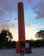 Quitsato Sundial, located on the Equator in Cayambe, Ecuador.
 -
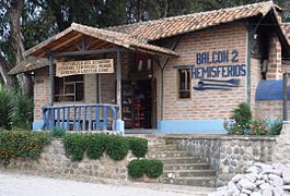 Balcon 2 Hemisferios, located on the Equator in Cayambe, Ecuador.
 -
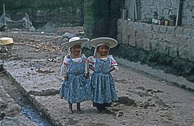 Two Otavalo girls in Cayambe.


See also edit
- Quitsato Sundial
- Dolores Cacuango, indigenous activist from Cayambe
References edit
- ^ Citypopulation.de Population and area of Cayambe
- ^ Bonifaz Andrade, Diego (1995). Guachalá: Historia de una hacienda en Cayambe. Abya-Yala. ISBN 978-9978041451.