Carson Peak is a 10,908-foot-elevation (3,325-meter) mountain summit located in the Sierra Nevada mountain range, in Mono County of northern California, United States.[3] It is situated in the Ansel Adams Wilderness, on land managed by Inyo National Forest. It is approximately 3.5 miles (5.6 km) southwest of the community of June Lake, 2.0 miles (3.2 km) south of Silver Lake, and 2.25 miles (3.62 km) northwest of San Joaquin Mountain, the nearest higher neighbor. The mountain is visible from various locations along the June Lake Loop, and from the nearby June Mountain ski area. The summit offers impressive views of Mount Ritter and Banner Peak. Topographic relief is significant as it rises 3,700 feet (1,100 meters) above the valley in 1.2 mile. The mountain consists of granite of Lee Vining Canyon.[4] Carson Peak is considered an eastern Sierra classic by backcountry skiers drawn to routes called the "Devils Slide" and "Petes Dream".[5]
| Carson Peak | |
|---|---|
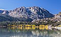
 North aspect reflected in Silver Lake | |
| Highest point | |
| Elevation | 10,908 ft (3,325 m)[1] |
| Prominence | 573 ft (175 m)[2] |
| Parent peak | San Joaquin Mountain (11,600 ft)[1] |
| Isolation | 2.24 mi (3.60 km)[1] |
| Listing |
|
| Coordinates | 37°44′51″N 119°07′27″W / 37.7475416°N 119.1241259°W[3] |
| Naming | |
| Etymology | Roy Carson |
| Geography | |
 Carson Peak Location in California  Carson Peak Carson Peak (the United States) | |
| Location | Ansel Adams Wilderness Mono County, California, U.S. |
| Parent range | Sierra Nevada |
| Topo map | USGS Mammoth Mountain |
| Geology | |
| Age of rock | Cretaceous |
| Mountain type | Fault block |
| Type of rock | Metamorphic rock |
| Climbing | |
| Easiest route | class 2[1] |
Climate edit
According to the Köppen climate classification system, Carson Peak has an alpine climate.[6] Most weather fronts originate in the Pacific Ocean, and travel east toward the Sierra Nevada mountains. As fronts approach, they are forced upward by the peaks, causing them to drop their moisture in the form of rain or snowfall onto the range (orographic lift). Precipitation runoff from this mountain drains into tributaries of Rush Creek.
History edit
The peak was named after Roy Carson, who died in 1949.[7] While Roy was employed by the Rush Creek Hydroelectric Project in the area, he established the area's first resort in 1916, known as Carson's Camp, at Silver Lake. The fishing resort featured tents until 1920 when the first cabin was completed. This geographical feature's name has been officially adopted by the U.S. Board on Geographic Names.[3]
Gallery edit
-
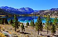
 Carson Peak from June Lake
 -
 Carson Peak in the summer, reflected in Silver Lake
 -
 Carson Peak from June Lake Loop
 -
 Carson Peak in autumn
 -
 The north chute, aka "Devils Slide", is the conspicuous line
 -
 Carson Peak centered beyond June Lake
 -
 Northeast aspect in winter
 -

-

-
 San Joaquin Mountain (left), Carson Peak (right) from June Lake


_(2).jpg)


See also edit
References edit
- ^ a b c d "Carson Peak - 10,908' CA". listsofjohn.com. Retrieved 2021-05-09.
- ^ "Carson Peak, California". Peakbagger.com. Retrieved 2021-05-09.
- ^ a b c "Carson Peak". Geographic Names Information System. United States Geological Survey, United States Department of the Interior. Retrieved 2021-05-09.
- ^ Lipshie, Steven R. (2001). Geologic guidebook to the Long Valley-Mono Craters region of Eastern California. South Coast Geological Society Publisher. p. 210.
- ^ Benson, Jeremy (2017). Backcountry Ski & Snowboard Routes: California. Mountaineers Books. ISBN 9781594859007.
- ^ Peel, M. C.; Finlayson, B. L.; McMahon, T. A. (2007). "Updated world map of the Köppen−Geiger climate classification". Hydrol. Earth Syst. Sci. 11 (5): 1633. Bibcode:2007HESS...11.1633P. doi:10.5194/hess-11-1633-2007. ISSN 1027-5606.
- ^ Peter Browning, Place Names of the Sierra Nevada: From Abbot to Zumwalt, Wilderness Press, 1986, ISBN 9780899970479, page 32.
External links edit
- Weather forecast: Carson Peak
- Webcam
- Carson Peak climbing: Mountainproject.com