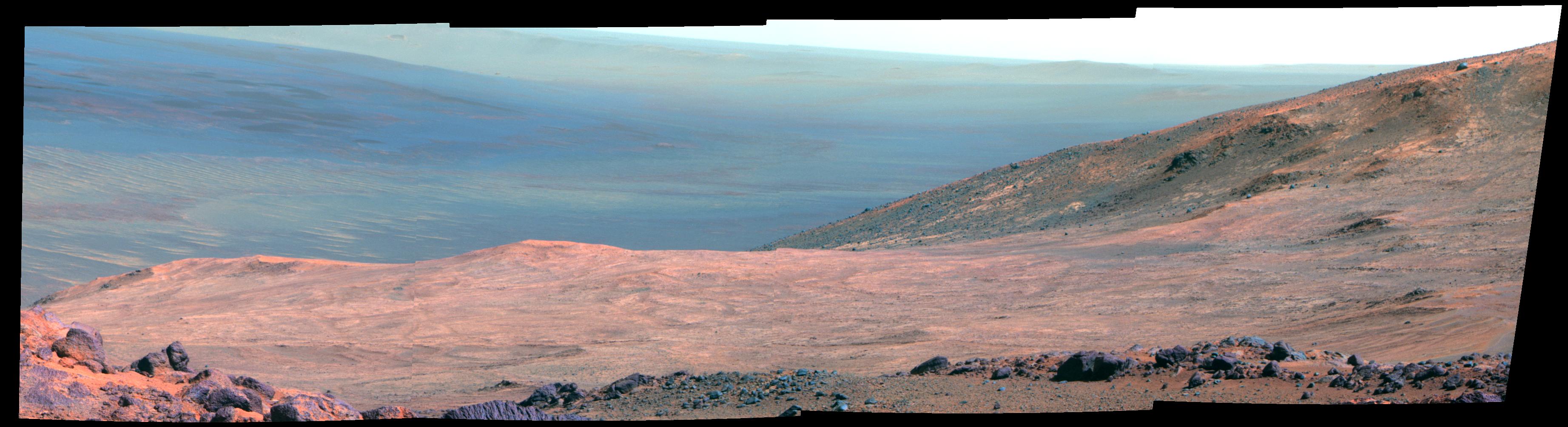
Cape Tribulation is a section of the Western rim of Endeavour crater on the planet Mars.[1] The MER-B Opportunity rover spent 30 months exploring Cape Tribulation from 2014 to 2017.[2] The top of Cape Tribulation is about 134 meters (440 feet) higher than the plains that surround the crater.[3]


The MER-B Opportunity rover summited Cape Tribulation in January 2015, which was the highest Martian elevation achieved yet on its mission.[4] Then in March 2016 it accomplished the distance of a classic marathon.[5] Also in March 2016 it achieved the steepest slope traverse (32 degree) yet of its mission, surpassing the slope it took on at Burns Cliff in 2004.[6] MER-B was trying to reach a target on Knudsen Ridge, on the south side of Marathon Valley, which meant attempting a steep grade which can cause wheel slippage.[7] Another effect of this angle was that sand and dust that had collected on the rover flowed in streaks over the back of the rover, such was the incline.[7]
Examples of locations:
- Cape Tribulation Summit
- Marathon Valley
- Spirit of Saint Lois Crater
- Spirit Mount
Endeavour crater is a 14-mile (23 km) wide crater on Mars, that was explored by the MER-B Rover Opportunity in the 2010s, after landing on the planet in 2004.[10]
Naming
editCape Tribulation is a reference to one of the locations visited by HMS Endeavour captained by James Cook in his first voyage of discovery to Australia and New Zealand in 1769-1771.
— NASA[3]
Wdowiak Ridge
editWdowiak Ridge is a section of the Western rim and is a raised section about 500 feet (150 meters) long and about 40 feet (12 meters) above surroundings.[11]

Summit
edit
On Sol 3894 (Jan. 6, 2015) Opportunity reached the summit of "Cape Tribulation," which is 443 feet (135 meters) above "Botany Bay" level and the highest point yet reached by the rover on western rim of Endeavour Crater according to NASA.[13]
Marathon valley
editIn 2015 MER-B entered Marathon Valley in Cape Tribulation and would study it until September 2016.[14]
Marathon Valley was targeted for exploration by MER-B because CRISM instrument in orbit on the Mars Reconnaissance Orbiter detected clay minerals at this location.[15]


Spirit of St. Louis Crater
editAlong Cape Tribulation, at the west end of Marathon Valley is a shallow crater about 110 feet (34 meters) long and about 80 feet (24 meters) wide, named "Spirit of St. Louis" after the record-breaking aircraft.[18] Within its center is a rock spire and the regolith in the crater has a darkened hue.[18] The crater is on the outer edge of the Western rom of Endeavour crater.[19] The MER-B rover reached it in April 2015 and took panoramic color photos of the site.[19]
Additional NASA team named features:
- Marathon Monument
- Donald A Hall
- Lindbergh Mound
- Roosevelt Field
- Lambert Field
- Harry H Knight
- Harold M Bixby

Context map
edit


Mineral map
edit
See also
edit- Cape York (Mars)
- Cape Tribulation (Earth)
External links
editReferences
edit- ^ "Catalog Page for PIA21497". photojournal.jpl.nasa.gov. Retrieved 2018-02-10.
- ^ "Catalog Page for PIA21497". photojournal.jpl.nasa.gov. Retrieved 2018-02-10.
- ^ a b "Mars Exploration Rover".
- ^ "MER-B Opportunity Cape Tribulation Summit Panorama". www.planetary.org. Retrieved 2018-02-10.
- ^ Northon, Karen (2015-03-25). "Opportunity Mars Rover Finishes Marathon in Just Over 11 Years". NASA. Retrieved 2018-02-10.
- ^ Greicius, Tony (2016-03-31). "Rover Takes on Steepest Slope Ever Tried on Mars". NASA. Retrieved 2018-02-10.
- ^ a b mars.nasa.gov. "Rover Takes on Steepest Slope Ever Tried on Mars". Mars planet facts news & images | NASA Mars rover + mission info. Retrieved 2018-02-11.
- ^ "Steep 'Knudsen Ridge' Along 'Marathon Valley' on Mars (Enhanced Color)". www.jpl.nasa.gov. Retrieved 2018-02-10.
- ^ "Mars Rover Opportunity's Panorama of 'Wharton Ridge'". www.jpl.nasa.gov. Retrieved 2018-02-11.
- ^ mars.nasa.gov. "Mars Exploration Rover". mars.nasa.gov. Retrieved 2018-02-11.
- ^ Greicius, Tony (2014-10-16). "NASA's Opportunity Rover Gets Panorama Image at 'Wdowiak Ridge'". NASA. Retrieved 2018-02-15.
- ^ "Catalog Page for PIA18614".
- ^ "Mars Exploration Rover Mission: All Opportunity Updates". mars.nasa.gov. Retrieved 2018-02-10.
- ^ "From 'Marathon Valley' to Gully on Endeavour Rim".
- ^ "Mars 'Marathon Valley' Overlook - Astrobiology Magazine". Astrobiology Magazine. Retrieved 2018-02-10.
- ^ https://mars.nasa.gov/resources/7782/ [dead link]
- ^ "Rover Takes on Steepest Slope Ever Tried on Mars".
- ^ a b Greicius, Tony (2015-04-30). "Rock Spire in 'Spirit of St. Louis Crater' on Mars". NASA. Retrieved 2018-02-10.
- ^ a b "Catalog Page for PIA19393". photojournal.jpl.nasa.gov. Retrieved 2018-02-10.
- ^ Martian Reminder of a Pioneering Flight
- ^ "Geologic Map, West Rim of Endeavour Crater, Mars". Jet Propulsion Laboratory.