Bula, officially the Municipality of Bula (Rinconada Bikol: Banwaān ka Bula; Tagalog: Bayan ng Bula), is a 1st class municipality in the province of Camarines Sur, Philippines. According to the 2020 census, it had a population of 73,143 people.[3]
Bula | |
|---|---|
| Municipality of Bula | |
 A view of native houses in Bula | |
 Flag  Seal | |
| Anthem: TAN-AW BULA | |
 Map of Camarines Sur with Bula highlighted | |
OpenStreetMap  | |
.svg) Bula Location within the Philippines | |
| Coordinates: 13°28′10″N 123°16′39″E / 13.4694°N 123.2775°E | |
| Country | Philippines |
| Region | Bicol Region |
| Province | Camarines Sur |
| District | 5th district |
| Barangays | 33 (see Barangays) |
| Government | |
| • Type | Sangguniang Bayan |
| • Mayor | Amelita A. Ibasco |
| • Vice Mayor | Nilo C. Malanyaon II |
| • Representative | Miguel Luis R. Villafuerte |
| • Municipal Council | Members |
| • Electorate | 44,669 voters (2022) |
| Area | |
| • Total | 167.64 km2 (64.73 sq mi) |
| Elevation | 24 m (79 ft) |
| Highest elevation | 263 m (863 ft) |
| Lowest elevation | 0 m (0 ft) |
| Population (2020 census)[3] | |
| • Total | 73,143 |
| • Density | 440/km2 (1,100/sq mi) |
| • Households | 15,468 |
| Economy | |
| • Income class | 1st municipal income class |
| • Poverty incidence | 25.05 |
| • Revenue | ₱234,489,389.53 (2020) |
| • Assets | ₱ 504.2 million (2020) |
| • Expenditure | ₱ 199 million (2020) |
| • Liabilities | ₱ 114.7 million (2020) |
| Service provider | |
| • Electricity | Camarines Sur 3 Electric Cooperative (CASURECO 3) |
| Time zone | UTC+8 (PST) |
| ZIP code | 4430 |
| PSGC | |
| IDD : area code | +63 (0)54 |
| Native languages | Rinconada Bikol Central Bikol Tagalog |
| Website | www |
History edit
The town of Bula is historically considered one of the first four mission towns of Camarines Sur founded by the Spanish conquistadores when they set foot on the Bicol soil coming from the Visayas in 1576. The other premier towns were Naga, Quipayo[Note 1] and Nabua.
The Spaniards who first came to this place asked the men who were splitting bamboo about the name of the area, and since they did not understand the language, they thought they were being asked about the name of the bamboo, so they got the answer "Bu-la." And so Bula became the name of the town.
However, it was only in 1578 when the natives were Christianized, so the National Historical Commission dates back the town's history to 1578. From this, the town chose St. Mary Magdalene as its patron saint and celebrated its fiesta every 22nd day of July, which is the birthdate of the saint.
The original location of Bula's town proper was located in the now Barangay Ombao Polpog. The location had to be changed due to the town proper's isolation from other Rinconada city centers.
Geography edit
Bula is bounded on the north by the municipalities of Pili and Ocampo, on the east by the municipality of Baao, on the southeast by the Municipality of Nabua, on the south it is bounded by the Municipality of Balatan, on the southwest by Ragay Gulf, and on the west by the Municipality of Minalabac.
Barangays edit
Bula is politically subdivided into 33 barangays. Each barangay consists of puroks and some have sitios.
- Bagoladio
- Bagumbayan
- Balaogan
- Caorasan
- Casugad
- Causip
- Fabrica
- Inoyonan
- Itangon
- Kinalabasahan
- La Purisima
- La Victoria
- Lanipga
- Lubgan
- Ombao Heights
- Ombao Polpog
- Palsong
- Panoypoyan
- Pawili
- Sagrada (Sagrada Familia)
- Salvacion (Poblacion)
- San Agustin
- San Francisco
- San Isidro
- San Jose
- San Miguel
- San Ramon
- San Roque (Poblacion)
- San Roque Heights
- Santa Elena
- Santo Domingo
- Santo Niño
- Taisan
Climate edit
| Climate data for Bula, Camarines Sur | |||||||||||||
|---|---|---|---|---|---|---|---|---|---|---|---|---|---|
| Month | Jan | Feb | Mar | Apr | May | Jun | Jul | Aug | Sep | Oct | Nov | Dec | Year |
| Mean daily maximum °C (°F) | 33 (91) |
32 (90) |
36 (97) |
37 (99) |
38 (100) |
37 (99) |
35 (95) |
33 (91) |
35 (95) |
34 (93) |
33 (91) |
32 (90) |
35 (94) |
| Mean daily minimum °C (°F) | 27 (81) |
27 (81) |
29 (84) |
31 (88) |
32 (90) |
32 (90) |
31 (88) |
29 (84) |
30 (86) |
29 (84) |
28 (82) |
28 (82) |
29 (85) |
| Average precipitation mm (inches) | 36.63 (1.44) |
49.6 (1.95) |
46.66 (1.84) |
78.81 (3.10) |
93.81 (3.69) |
135.51 (5.34) |
326.31 (12.85) |
406.1 (15.99) |
214.85 (8.46) |
313.98 (12.36) |
76.2 (3.00) |
262 (10.3) |
2,040.46 (80.32) |
| Average rainy days | 19 | 23 | 17 | 19 | 23 | 27 | 31 | 29 | 27 | 29 | 24 | 29 | 297 |
| Source: World Weather Online[5] | |||||||||||||
Demographics edit
| Year | Pop. | ±% p.a. |
|---|---|---|
| 1903 | 2,859 | — |
| 1918 | 5,346 | +4.26% |
| 1939 | 11,750 | +3.82% |
| 1948 | 11,952 | +0.19% |
| 1960 | 24,257 | +6.07% |
| 1970 | 31,506 | +2.65% |
| 1975 | 36,904 | +3.22% |
| 1980 | 40,642 | +1.95% |
| 1990 | 48,240 | +1.73% |
| 1995 | 54,650 | +2.37% |
| 2000 | 57,474 | +1.09% |
| 2007 | 62,024 | +1.06% |
| 2010 | 68,011 | +3.41% |
| 2015 | 69,430 | +0.39% |
| 2020 | 73,143 | +1.03% |
| Source: Philippine Statistics Authority[6][7][8][9] | ||
In the 2020 census, the population of Bula, Camarines Sur, was 73,143 people,[3] with a density of 440 inhabitants per square kilometre or 1,100 inhabitants per square mile.
Language edit
Majority of the people speak the Bula-Pili variant, a lowland dialect (sinaranəw) of Rinconada Bikol language, also known as Riŋkonāda. The population can also understand and speak Tagalog or Filipino language and English.
Religion edit
Majority of the population are Roman Catholic members which is the biggest bulk of Bulaeños adhering to Christian faith. The rest of population are followers of different Protestant denominations.[10]
Economy edit
Graphs are unavailable due to technical issues. There is more info on Phabricator and on MediaWiki.org. |
Despite staying as a 2nd class municipality, there have been improvements brought along by the Local Government Unit from the mid-2010s to the present to the year. This is because some areas need improvement of infrastructures. This also makes Bula a 1st class municipality.
Commercial and Industrial edit
Commercial and Industrial are focused in the Centro part of the town situated in Sagrada. At the start of the 2020s, Micro Businesses in the town bloomed — recent developments such as the Palmeda Transcend Park in Brgy. Sagrada Familia acts as a center for Micro and franchise businesses.
Agriculture edit
The agricultural output of Bula mainly consists of Rice, Wheat, Coconut, and Corn.
Tourism edit
The town of Bula has views of Tan-Awan Park, Nalalata Falls, and Burabod. Tan-Awan Park, located in Barangay Bagoladio atop a hill, attracts a number of tourists because of its views overlooking the areas of its neighboring towns in Rinconada.[citation needed]
Bula is also home to beaches on its easternmost side, neighboring Minalabac in the north and Balatan to the south.
Gallery edit
-
 Bula Municipal Building
 -
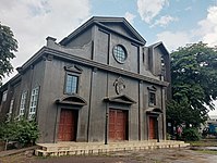 St. Mary Magdalene Parish Church
 -
 Bula Catholic Cemetery
 -
 Bula Public Market
 -
 Bula National High School
 -
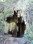 Nalalata Cave
 -
 Nalalata Falls
 -
 Bula Parochial School

.jpg)


Notes edit
References edit
- ^ Municipality of Bula | (DILG)
- ^ "2015 Census of Population, Report No. 3 – Population, Land Area, and Population Density" (PDF). Philippine Statistics Authority. Quezon City, Philippines. August 2016. ISSN 0117-1453. Archived (PDF) from the original on May 25, 2021. Retrieved July 16, 2021.
- ^ a b c Census of Population (2020). "Region V (Bicol Region)". Total Population by Province, City, Municipality and Barangay. Philippine Statistics Authority. Retrieved 8 July 2021.
- ^ "PSA Releases the 2018 Municipal and City Level Poverty Estimates". Philippine Statistics Authority. 15 December 2021. Retrieved 22 January 2022.
- ^ "Camarines Sur: Average Temperatures and Rainfall". World Weather Online. Retrieved 29 October 2017.
- ^ Census of Population (2015). "Region V (Bicol Region)". Total Population by Province, City, Municipality and Barangay. Philippine Statistics Authority. Retrieved 20 June 2016.
- ^ Census of Population and Housing (2010). "Region V (Bicol Region)" (PDF). Total Population by Province, City, Municipality and Barangay. National Statistics Office. Retrieved 29 June 2016.
- ^ Censuses of Population (1903–2007). "Region V (Bicol Region)". Table 1. Population Enumerated in Various Censuses by Province/Highly Urbanized City: 1903 to 2007. National Statistics Office.
{{cite encyclopedia}}: CS1 maint: numeric names: authors list (link) - ^ "Province of Camarines Sur". Municipality Population Data. Local Water Utilities Administration Research Division. Retrieved 17 December 2016.
- ^ Tino, Marilou (Nov 25, 2019). "THE ROMAN CATHOLIC CHURCH IN CAMARINES SUR: A WITNESS TO HISTORY".
{{cite journal}}: Cite journal requires|journal=(help) - ^ "Poverty incidence (PI):". Philippine Statistics Authority. Retrieved December 28, 2020.
- ^ "Estimation of Local Poverty in the Philippines" (PDF). Philippine Statistics Authority. 29 November 2005.
- ^ "2003 City and Municipal Level Poverty Estimates" (PDF). Philippine Statistics Authority. 23 March 2009.
- ^ "City and Municipal Level Poverty Estimates; 2006 and 2009" (PDF). Philippine Statistics Authority. 3 August 2012.
- ^ "2012 Municipal and City Level Poverty Estimates" (PDF). Philippine Statistics Authority. 31 May 2016.
- ^ "Municipal and City Level Small Area Poverty Estimates; 2009, 2012 and 2015". Philippine Statistics Authority. 10 July 2019.
- ^ "PSA Releases the 2018 Municipal and City Level Poverty Estimates". Philippine Statistics Authority. 15 December 2021. Retrieved 22 January 2022.