Bray Head (Irish: Ceann Bhré) is a 241 m (791 ft) hill and headland located in northern County Wicklow, Ireland, between the towns of Bray and Greystones. It forms part of the Wicklow Mountains and is a popular spot with hillwalkers. At the top of the head is a concrete cross which was placed there in 1950 during the holy year. Every Good Friday, hundreds of local people climb to the top of the head in a Good Friday procession marking the stations of the Cross as they go along, with the final station being held at the holy year cross.[1] The headland and adjacent lands were designated under a Special Amenity Area Order in March 2008.[2]
| Bray Head | |
|---|---|
| Ceann Bhré | |
 South side of Bray Head, viewed from Greystones harbour | |
| Highest point | |
| Elevation | 243 m (797 ft) |
| Coordinates | 53°11′25.90″N 6°05′03.00″W / 53.1905278°N 6.0841667°W |
| Geography | |
 Bray Head | |
| Parent range | Wicklow Mountains |
The most direct way to reach the cross at the top (about 190m above sea level) is via an ascending footpath that begins just outside the free car park on the lower, northern slopes, to the south of Bray Esplanade. This is a half-hour walk for a fit person. The footpath, after the initial section with cut steps, is a rough path formed by rainwater and ascending through natural woodland. A more gradual route can be taken from the Southern Cross, by Bray Golf Club, which is easier underfoot. There is also a route which ascends from the Greystones side of the cliff walk; this route leads quite directly up the east side of the hill and as a result is quite steep, Upon reaching the top you can then walk the path along to the cross.
The Dublin-Wicklow railway line runs outside of Bray Head along the coast, sometimes travelling within feet of the cliffs. This line, designed by Isambard Kingdom Brunel, is referred to as Brunel's Folly, due to the ongoing maintenance costs associated with maintaining a cliff-face line. The line had to be diverted on three occasions in 1876, 1879, and 1917.[3] A serious accident occurred on 9 August 1867 when a passenger train derailed on nearby Brandy Hole Viaduct, causing the deaths of two passengers.[4] The rail trip between Dublin and Bray Daly railway station, the nearest station to Bray Head, takes approximately 45 minutes.
On the morning of 14 April 2012, a waterspout was observed just off the coast of Bray Head.[5]
The slate sea-cliffs at Bray Head have been established as a minor rock-climbing location since the 1970s, though a few of the climbs were originally recorded in the 1940s. The 2009 guidebook lists 27 single-pitch climbs, generally in the lower grades, up to HVS.[6][7]
Gallery edit
-
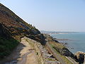 The Bray to Greystones Cliff Walk
 -
 The railway along the cliffs of Bray Head with traces of the old alignment
 -
 The Holy Year Cross on summit of Bray Head
 -

-
 Bray Head in flames, 2018


See also edit
References edit
- ^ Morgan Ilaw (2 October 2015). "Bray Head Holy Year Cross". DBS Irish Studies.
- ^ O'Brien, Tim (14 March 2008). "Bray Head gets special status after 15-year campaign". The Irish Times. Archived from the original on 24 March 2012. Retrieved 30 August 2008.
- ^ "Bray Head". Eiretrains. Retrieved 23 January 2018.
- ^ W. Yolland (20 August 1867). "Letter to the Bord of Trade (Railway Department)" (PDF).
- ^ Patrick Counihan (15 April 2012). "Freak water tornado hits Wicklow coastal town of Bray". IrishCentral.
- ^ "Bray Head". Irish Climbing Online Wiki. Retrieved 23 November 2020.
- ^ Joe Lyons, ed. (2009), Wicklow: Rock Climbing Guide, Mountaineering Ireland, ISBN 978-0-902940-23-9