The Arnos Park Viaduct is a railway viaduct of 34 brick arches that was built as part of the extension of London Underground's Piccadilly line from Finsbury Park in the south to Cockfosters in the north. It was built in 1932 and opened in 1933. It starts on the southern edge of Arnos Park soon after Arnos Grove station and ends on the northern side of the park, where the line enters a tunnel that continues to Southgate.


Background edit
The viaduct was built as part of London Underground's project to extend the Piccadilly line from Finsbury Park in the south to Cockfosters in the north which started in 1930.[1] The extension was built in stages, first to Arnos Grove station (opened 1932[2]), then to Oakwood (then known as Enfield West),[3] during which phase the viaduct was constructed, and finally to Cockfosters. The entire project cost more than £5 million.[1]
The viaduct edit
The viaduct starts at the southern edge of Arnos Park and ends on the northern side of Hampden Way, opposite Morton Way. The Pymmes Brook runs parallel to the viaduct in the north and then under it before continuing eastward.[4] The viaduct is made of brick[5] and consists of 34[6] numbered arches, broken only by two bridges where it passes over Waterfall Road and Hampden Way. The railway line then enters a tunnel half a mile long in which Southgate station is located before continuing north to Oakwood and Cockfosters.[3] The combination of a viaduct followed fairly soon after by a long tunnel was made necessary by the need to keep the line as level as possible as it crossed the Pymmes Brook valley, then went under high ground at Southgate before continuing above ground to Oakwood and Cockfosters. The viaduct opened in 1933.[2]
Gallery edit
-
 The bridge over Waterfall Road from the west
 -
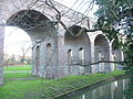 The viaduct viewed from Waterfall Road, with the Pymmes Brook in the foreground
 -
 Blind arches near Waterfall Road


References edit
- ^ a b "Underground Railways: Big Extension Scheme in London", The Press, Vol. LXVI, Issue 20029, 10 September 1930, p. 11.
- ^ a b Haywood, Russell (2009). Railways, urban development and town planning in Britain: 1948–2008. Farnham: Ashgate. p. 342. ISBN 978-1-4094-8825-5.
- ^ a b The Tramway and Railway World. Vol. 73, 1933.
- ^ Arnos Park. London Gardens Online. Retrieved 18 January 2016.
- ^ Pevsner, Nikolaus & Bridget Cherry (2002). The buildings of England London 4: North. New Haven & London: Yale University Press. p. 461. ISBN 0300096534.
- ^ Dumayne, Alan. (1998) Southgate in old photographs. Sutton Publishing. p. 41. ISBN 0-7509-2000-9.