Wireless Hill Park is a 40-hectare (99-acre) park in Ardross, Western Australia that is the location of the former Applecross Wireless Station,[a] an early radio station in Western Australia. The station buildings have been preserved and now house the Wireless Hill Museum. The site is listed in the Register of the National Estate[1][5] and the State Register of Heritage Places.
| Wireless Hill Park | |
|---|---|
 Playground at Wireless Hill Park | |
 | |
| Location | Ardross, Western Australia |
| Coordinates | 32°01′45″S 115°49′39″E / 32.02921°S 115.82758°E |
| Open | |
| Designated | 2 September 1997 |
| Reference no. | 3518 |
The park is also a significant urban bushland area.
History edit
In 1909 the Commonwealth Government decided that wireless telegraphy stations should be established around the coastline of Australia, and in 1910 awarded the contract for the Perth station to Australasian Wireless Limited. Clearing of the site and construction began in 1911, with the Applecross Wireless Station completed and officially opened on 30 September 1912.[6][1][2]
The station was initially owned and operated by Australasian Wireless, on behalf of the Postmaster-General's Department (PMG),[b] as a commercial service for shipping.[8][9]
In 1916, as a consequence of World War I, the Royal Australian Navy took control of the station (and all Australian coastal radio stations), retaining existing staff and giving them naval ranks as non-commissioned officers.[2][8][10] The Navy retained control until 1920.[1][2] The Navy took control of the station again from 1939 to 1945, during World War II,[1][2] again retaining the existing staff.[11]
In 1947 the newly formed Overseas Telecommunications Commission (OTC) took control over all wireless stations from the PMG.[2]
Between 1967 and 1968 OTC moved all of its operations from Wireless Hill to its new station in Gnangara, and in 1968 the Wireless Hill station closed.[8] The land was transferred to the City of Melville in 1969, and in 1971 was formally renamed as Wireless Hill Park. (The site was already commonly referred to as Wireless Hill by the local residents.)[12]: 117 [2]
In 1970 the West Australian VHF Group (an amateur radio club) proposed establishing a telecommunications museum.[1] In 1974 work began on converting the station, and in 1979 the Wireless Hill Telecommunications Museum was officially opened[2] as a contribution to Western Australia's sesquicentennial celebrations.[1] In 2015, after refurbishment, the museum was re-opened as the Wireless Hill Museum.[13][14]
Wireless Hill Park was classified by the National Trust of Australia in 1992,[1][2] and listed on the Western Australian Register of Heritage Places in 1997.[15]
Telecommunications edit
 Wireless Hill Museum, 2006 | |
 | |
| Established | 1974 |
|---|---|
| Location | Ardross, Western Australia |
| Coordinates | 32°01′49″S 115°49′41″E / 32.030388°S 115.828011°E |
| Website | www |
Building details | |
| Former names | Engine House[1] |
| Alternative names | Engine Room |
| General information | |
| Groundbreaking | 1911 |
| Opened | 30 September 1912 |
| Official name | Engine House (fmr) |
| Designated | 3 Aug 1992 |
| Reference no. | 3825 |
Buildings and structures edit
At the top of the hill are three main buildings, originally known as:[1][2][8]
- Engine House or Engine Room, built in 1912, originally held the generator used to power the transmitter. In 1942 the generator was removed and the radio equipment was moved into this building, which then became known as the Transmitter Hall.
- Operator's House or Operator's Room, built in 1912, the location of the radio equipment until 1942.
- Stores building, added c. 1915.
Initially, a 120 m (390 ft) antenna mast was erected, held in place by three guy-wires, each attached to a 4.6 m (15 ft) 200-ton concrete anchor block.[1][2][16][17] In 1930 a light was added to the top of the mast, as was required of all structures exceeding 200 ft (61 m), to warn aircraft at night of the mast's existence.[18] The original mast was replaced in 1962 by a 46 m (151 ft) mast, the taller mast no longer being required by the newer technology. The mast was removed in 1967.[1][2] Previously two of the anchor blocks were used as viewing platforms, however only the north anchor block is now used as a viewing platform.
In 1947 three timber distribution towers were constructed to feed rhombic antennae;[2] these were removed c. 1970.[1]
At the bottom of the hill, on Hickey Street near Canning Highway, four cottages were built as staff accommodation. The road between the cottages and the main station buildings was known as Radio Drive, and was possibly the first macadamised road in Perth.[1][8]
Notable equipment edit
When the station opened in 1912 it used a 25 kW quenched spark-gap transmitter manufactured by Telefunken, and a receiver with a locally built crystal detector (using galena from Northampton).[8][10][9] In 1916 the transmitter was upgraded (by the Navy) to a 60 kW Poulsen arc transmitter and vacuum tube receiver.[1][2]
Initially all radio transmissions used Morse code; the technology to transmit voice was developed in the 1920s,[9][19] and even then Morse code was still the primary method for long distances up until the station closed in 1968.[1]
In 1927 a shortwave "beam system" was installed, which extended the transmission range sufficiently to allow direct communication between Australia and England.[2]
The original transmitter was powered by diesel-driver alternator. By 1934 the equipment was powered by externally supplied three-phase power, with the generator kept for emergency standby use.[20]
Numerous antennae were added to the site over the years, each for a specific purpose, particularly after OTC took control of the station. In 1960 two rhombic antennae were installed for use with NASA space missions,[1][2] bringing the total number of antennae up to 22.[21]
Radio services edit
The Wireless Hill station provided a variety of radio services during its operational lifetime.
Initially the station was used for communications with shipping. This included transmission of weather forecasts, news bulletins and time signals, sending medical advice to ships with no doctors aboard, and monitoring for distress calls.[1][22][9] In 1921 the station exchanged signals with SS Aeneas over a distance of 9,000 kilometres (5,600 mi), the longest distance for any Australian station at the time.[10]
The Wireless Hill station provided the first direct radio communications across the Australian continent,[23] and communicated with bases in the Antarctic,[1] including Mawson Station in the 1950s and 1960s.[9]
The original call sign of the station was POP; by the 1920s it was known as VIP.[22][24][9]
During World War I, the station monitored German transmissions, including propaganda from Nauen Transmitter Station in Germany.[9][25][12]: 114
Police radio (VK-1) was transmitted from Wireless Hill, operated remotely from police headquarters in Roe Street, Perth. Initially, in the late 1920s, two patrol cars in Perth were equipped with radios.[1][26]
Western Australia's first commercial radio station, 6PR, was broadcast from Wireless Hill between 1931 and 1950, relayed from a studio in Barrack Street.[1][27][28] Western Australia's first television service (TVW7) was broadcast in 1959.[1][2]
In the 1960s the station provide communications to the US rescue aircraft that flew continuously over the Indian Ocean when NASA were conducting a Mercury mission.[1]
A shortwave antenna was installed in the 1970s, and is still in use by the WA VHF Group.[21]
After Cyclone Tracy hit Darwin in 1975, destroying or disabling much of its communications infrastructure, the WA VHF Group helped provided communications between Darwin and Perth.[1]
In the 1980s an antenna was added to the Stores building, which became the control centre for the State Emergency Service.[1][22]
Since 2002 Wireless Hill has been home to Capital Community Radio's studios and one of their transmitters.[2][28][29]
Bushland edit
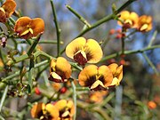
Wireless Hill Park comprises 38 hectares (94 acres) of bushland surrounding 2 hectares (5 acres) of grass parkland.[30] The bushland is home to numerous wildflowers, native plants,[31] birds and reptiles.[32][33] It is listed as site 336 on "Bush Forever",[31][34] a state government policy to protect regionally significant bushland.[35]
Much of the area was cleared when the Applecross Wireless Station was originally built[36] or shortly afterwards during World War I for security reasons.[1] Perennial veldtgrass was planted to prevent soil erosion, but the bush has regenerated itself from seeds from plants in surrounding areas.[33][36]
The park has several walking paths through it.[37][38]
-
 Grass trees
 -
-


Aboriginal heritage edit
Wireless Hill is on the land of the Beeliar people.[1] It was known as Yagan Mia or Yagan's Lookout,[c] after the Aboriginal leader who used the area as a home base and vantage point.[39][40][41]
The park includes a scarred tree, used by indigenous Australians to create utensils or shields, or to mark territory.[39][40][41]
See also edit
Notes edit
- ^ When the station was constructed, the site was in Applecross.[1][2] Due to subsequent changes to suburban boundaries, the site is now in Ardross.[3][4]
- ^ The Wireless Telegraphy Act 1905 gave the Commonwealth Government the exclusive right to establish and operate radio stations.[2][7]
- ^ According to one sign on the "Yagan's Genunny" walking trail, "This hill was known to be a camping place (mia) and lookout (genunny) of Yagan ...".
References edit
- ^ a b c d e f g h i j k l m n o p q r s t u v w x y z aa Cathleen Day (January 2012), Wireless Hill Telecommunication Museum Collection Significance Assessment, retrieved 9 June 2014
- ^ a b c d e f g h i j k l m n o p q r s Kelly Aris; Helen Burgess; Gaye Nayton (2015), "Applecross Wireless Station Historical Timeline" (PDF), Conservation Plan Applecross Wireless Station (fmr), Wireless Hill Park, Ardross, City of Melville, retrieved 3 September 2017
- ^ "Park & national heritage listing", Information displayed inside the Wireless Hill Telecommunications Museum, 2012-10-14
- ^ "Wireless Hill Park Remoteness & Connectivity", Information displayed outside the Wireless Hill Museum, 2015-05-17
- ^ "The Engine Room", Information displayed inside the Wireless Hill Museum, 2015-05-17
- ^ "The Wireless Circuit. Applecross Station officially opened yesterday". The West Australian. Perth, WA. 1 October 1912. p. 7. Retrieved 19 May 2013.
- ^ Roger Meyer. "The Role of Coastal Radio Stations in the Early Days of Communications With Aircraft". Retrieved 15 October 2012.
- ^ a b c d e f A centenary of Wireless Hill, City of Melville, 2012
- ^ a b c d e f g The Wire: A History of Morse Code, City of Melville, 2017, retrieved 6 September 2017
- ^ a b c W S Cooper & G McDonald (1989). A City for all Seasons, The Story of Melville. City of Melville. pp. 166–167. ISBN 0-949663-02-6.
- ^ "Coastal Radio Service in Australia during WWII". Peter Dunn. 5 January 2009. Retrieved 15 October 2012.
- ^ a b Malcolm Uren (1975). The City of Melville, From bushland to expanding metropolis. Melville City Council.
- ^ "Wireless Hill Museum Reopens". City of Melville. Retrieved 18 May 2015.
- ^ "The Museum", Information displayed inside the Wireless Hill Museum, 2015-05-17
- ^ "Wireless Hill Park (place number 03518)". State Heritage Register. Government of Western Australia, State Heritage Office. 8 February 2015. Retrieved 17 May 2015.
- ^ "Drahtlose Verbindung mit Telefunkensystem quer durch Australien" [Wireless Connection with System by Telefunken right across Australia] (PDF). Telefunken Zeitung (in German). 2 (8). Berlin: Telefunken-Gesellschaft: 38–41. October 1912. Retrieved 5 January 2019.
- ^ "Southern Anchor Block", Information displayed outside the Wireless Hill Museum, 2015-05-17
- ^ "A New 'Star'". The Radiogram. AWA. April 1930. p. 23., as reproduced in A Centenary of Wireless Hill, City of Melville, 2012
- ^ "Morse telegraphy", Information displayed inside the Wireless Hill Telecommunications Museum, 2012-10-14
- ^ "High voltage 3 Phase Power", Information displayed inside the Wireless Hill Museum, 2015-05-17
- ^ a b "The mast & anchor blocks", Information displayed inside the Wireless Hill Telecommunications Museum, 2012-10-14
- ^ a b c "Broadcasting – Perth Radio POP VIP", Information displayed inside the Wireless Hill Telecommunications Museum, 2012-10-14
- ^ "Historic Engineering Marker, Perth Wireless Station", plaque dedicated by the Institution of Engineers, Australia in 1994, outside the Wireless Hill Telecommunications Museum, 2015-05-17
- ^ "Perth MCS". Retrieved 15 October 2012.
- ^ "World War I", Information displayed inside the Wireless Hill Telecommunications Museum, 2012-10-14
- ^ "Police wireless – Call sign VK1", Information displayed inside the Wireless Hill Telecommunications Museum, 2012-10-14
- ^ "We're 80 years young". 6PR. 13 October 2011. Archived from the original on 16 October 2011. Retrieved 15 October 2012.
- ^ a b "6PR & commercial radio", Information displayed inside the Wireless Hill Telecommunications Museum, 2012-10-14
- ^ "About us". Capital Community Radio Inc. Retrieved 4 July 2013.
- ^ Wireless Hill Reserve Management Plan, City of Melville, August 2008, retrieved 13 October 2018
- ^ a b "Wildflowers and other Native Plants". Friends of Wireless Hill. Retrieved 15 October 2012.
- ^ "Birds and Reptiles". Friends of Wireless Hill. Retrieved 15 October 2012.
- ^ a b "Biodiversity & Ecology of Wireless Hill", Information displayed outside the Wireless Hill Museum, 2015-05-17
- ^ List of Current Bush Forever Sites, and Managers for each Site (PDF), August 2012, retrieved 15 October 2012
- ^ "Bush Forever". Urban Bushland Council WA Inc. Retrieved 15 October 2012.
- ^ a b "About Wireless Hill Park". Friends of Wireless Hill. Retrieved 15 October 2012.
- ^ "Recreation". Friends of Wireless Hill. Retrieved 15 October 2012.
- ^ "Wireless Hill Interpretive Signage and Heritage Trails". City of Melville. Retrieved 4 September 2017.
- ^ a b Whadjuk Boodja: Aboriginal Land, City of Melville, 2016
- ^ a b "History". Friends of Wireless Hill. Retrieved 4 September 2017.
- ^ a b "Aboriginal History in the City of Melville". City of Melville. Archived from the original on 14 July 2016. Retrieved 19 July 2015.
External links edit
- Official website

- Wireless Hill Museum
- West Australian VHF Group, the amateur radio group based at Wireless Hill and involved in the museum's creation
- Wireless Hill Centenary Exhibition Installation, a video showing the construction and layout of the interior of the Wireless Hill Museum for its centenary in 2012.