Pengjia Islet (Chinese: 彭佳嶼; pinyin: péng jiā yǔ[6][7]), also known as P'eng-chia Hsü, Hōka-sho,[8] Agincourt,[3][9] Dashihshan Islet, Chaolai Islet, P'eng-chia Yü or Pengchia Islet, is an islet north of Taiwan and is administered under Zhongzheng District, Keelung City. It is under Taiwanese military control and cannot be visited by ordinary citizens.[3]
Native name: 彭佳嶼 | |
|---|---|
 | |
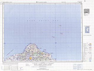
 P'eng-chia Yü north of Taiwan Island | |
 Pengjia Islet Location in the East China Sea | |
| Geography | |
| Location | Zhongzheng, Keelung, Taiwan[1][2][3][4] |
| Area | 1.14 km2 (0.44 sq mi)[5] |
| Administration | |
Republic of China (Taiwan) | |
| Province | Taiwan (streamlined) |
| Provincial city | Keelung |
| District | Zhongzheng |
| Additional information | |
| Time zone | |

History edit
In September 1984, forty plus fishing boats from Japan intruded on the territorial waters of Pengchia Islet (Pengjia Islet). Their catch was estimated to be worth 20 million TWD.[10]
On 7 September 2012 and again on 9 April 2016, President Ma Ying-jeou visited Pengjia Islet.[4][11]
Geography edit
Pengjia Islet part of Zhongzheng, Keelung, Taiwan (ROC). The islet is located to the northeast of Keelung. The islet is surrounded by cliffs on its eastern, southern and northern sides. On the western side, the sea is full of reef and rocks. The only safe way to land on the island is via the dock on the southwestern side.[6]
Climate edit
| Climate data for Pengjia Islet (1991–2020 normals, extremes 1910–present) | |||||||||||||
|---|---|---|---|---|---|---|---|---|---|---|---|---|---|
| Month | Jan | Feb | Mar | Apr | May | Jun | Jul | Aug | Sep | Oct | Nov | Dec | Year |
| Record high °C (°F) | 26.4 (79.5) |
27.5 (81.5) |
28.8 (83.8) |
30.8 (87.4) |
32.7 (90.9) |
33.9 (93.0) |
35.9 (96.6) |
35.6 (96.1) |
34.0 (93.2) |
32.8 (91.0) |
29.2 (84.6) |
28.4 (83.1) |
35.9 (96.6) |
| Mean daily maximum °C (°F) | 17.9 (64.2) |
18.5 (65.3) |
20.3 (68.5) |
23.4 (74.1) |
26.4 (79.5) |
29.3 (84.7) |
31.3 (88.3) |
31.1 (88.0) |
29.0 (84.2) |
25.9 (78.6) |
23.1 (73.6) |
19.6 (67.3) |
24.7 (76.4) |
| Daily mean °C (°F) | 15.8 (60.4) |
16.2 (61.2) |
17.7 (63.9) |
20.7 (69.3) |
23.6 (74.5) |
26.3 (79.3) |
28.1 (82.6) |
28.0 (82.4) |
26.4 (79.5) |
23.8 (74.8) |
21.1 (70.0) |
17.6 (63.7) |
22.1 (71.8) |
| Mean daily minimum °C (°F) | 13.9 (57.0) |
14.2 (57.6) |
15.5 (59.9) |
18.5 (65.3) |
21.6 (70.9) |
24.3 (75.7) |
26.0 (78.8) |
25.9 (78.6) |
24.7 (76.5) |
22.2 (72.0) |
19.4 (66.9) |
15.8 (60.4) |
20.2 (68.3) |
| Record low °C (°F) | 2.4 (36.3) |
4.5 (40.1) |
5.2 (41.4) |
7.8 (46.0) |
12.8 (55.0) |
15.5 (59.9) |
18.9 (66.0) |
19.9 (67.8) |
18.0 (64.4) |
12.7 (54.9) |
6.0 (42.8) |
4.4 (39.9) |
2.4 (36.3) |
| Average precipitation mm (inches) | 115.9 (4.56) |
122.2 (4.81) |
134.9 (5.31) |
130.0 (5.12) |
193.8 (7.63) |
190.9 (7.52) |
109.6 (4.31) |
185.9 (7.32) |
196.7 (7.74) |
124.5 (4.90) |
121.9 (4.80) |
127.0 (5.00) |
1,753.3 (69.02) |
| Average precipitation days (≥ 0.1 mm) | 16.3 | 15.4 | 17.0 | 13.8 | 13.2 | 11.5 | 6.2 | 9.7 | 11.1 | 11.1 | 14.4 | 14.9 | 154.6 |
| Average relative humidity (%) | 77.6 | 79.4 | 80.6 | 82.0 | 84.6 | 87.5 | 85.6 | 85.1 | 82.5 | 77.0 | 77.9 | 76.1 | 81.3 |
| Mean monthly sunshine hours | 62.3 | 62.7 | 90.8 | 110.2 | 143.0 | 177.9 | 276.2 | 253.6 | 203.6 | 154.8 | 94.1 | 65.9 | 1,695.1 |
| Source: Central Weather Bureau[12][13][14][15][16] | |||||||||||||
Demographics edit
There are no long-term residents on the islet. As of 2002, there were about 40 itinerant residents living on the island, who are mostly employees of the weather observatory and coast guard divisions.[6][17]
The island had over 100 inhabitants in the 1890s, when George MacKay wrote From Far Formosa (see page 185).
Infrastructures edit
Maps edit
-
 Map including Pengjia Islet (labeled as Pon-kia) (1752)
 -
 Map of Pengjia Islet (labeled as HŌKA-SHO (AGINCOURT ISLAND)) (AMS, 1944)
 -
 Map including Pengjia Islet (labeled as P'eng-chia Hsü (Hōka-sho) 彭佳嶼) (AMS, 1950)
 -
 Map including Pengjia Islet (labeled as P'eng-chia Hsü) (1962)
.jpg)


See also edit
References edit
- ^ 今日中正 [Today's Zhongzheng]. 基隆市中正區公所. Retrieved 23 April 2019.
3.本區北面面臨太平洋,並包括有和平島、彭佳嶼、基隆嶼、棉花嶼、花瓶嶼等島嶼自然地理景觀豐富
- ^ 基隆市土地段名代碼表 (in Chinese (Taiwan)). Department of Land Administration. 16 December 2014. Retrieved 22 September 2019.
基隆市土地段名代碼表 地政事務所名稱(代碼) 信義(CB) 鄉鎮市區名稱(代碼) 中正區(01){...}段 小段 代碼 備註{...}彭佳嶼 0026
- ^ a b c "Beautiful Scenery". Keelung City Government. Retrieved 23 April 2019.
Pengjia Islet (Agincourt){...}This islet remains a military control district; hence, citizen is not allowed to visit the islet. However, one might be able to see the islet by taking a fishing boat to sail around the islet.
- ^ a b "Pengjia Islet gets rare attention from Ma's visit". GlobalSecurity.org. 7 September 2012.
The normally obscure outcrop, which falls administratively under Keelung City, is one of three islets off of Taiwan's northern coast -- the others are Mianhua Islet and Huaping Islet -- considered to be of strategic importance to the country.
- ^ 彭佳嶼 [Pengjia Islet]. 海洋委員會海巡署北部分署 Northern Branch, Coast Guard Administration, Ocean Affairs Council (in Chinese (Taiwan)). 7 January 2016. Retrieved 25 September 2019.
(三)面積:1.14平方公里(0.44平方英里)
- ^ a b c 教育部重編國語辭典修訂本 (in Chinese (Taiwan)). Retrieved 28 September 2019.
字詞 【彭佳嶼】 注音 ㄆㄥˊ ㄐㄧㄚ ㄩˇ 漢語拼音 péng jiā yǔ 釋義 島名。位於基隆東北方隸屬基隆市。島上東、南、北三面都是斷崖,西岸多礁石,唯一安全的登陸點是西南岸的碼頭。島上無常住人口,只有看守燈塔及氣象站的工作人員。
- ^ 臺灣歷史地圖 增訂版 [Taiwan Historical Maps, Expanded and Revised Edition] (in Chinese (Taiwan)). Taipei: National Museum of Taiwan History. February 2018. p. 119. ISBN 978-986-05-5274-4.
方地灣臺{...}嶼佳彭{...}1938年
- ^ "Map: Tai-pei Shei". legacy.lib.utexas.edu. Retrieved 4 August 2021.
- ^ "Index to the New Map of China (In English and Chinese)". Shanghai: Far Eastern Geographical Establishment. 1914. p. 1.
Agincourt Island ... 愛近高脫島 Formosa ... 臺灣 ... 25.38N 122.7 E
- ^ "China Report POLITICAL, SOCIOLOGICAL AND MILITARY AFFAIRS". Foreign Broadcast Information Service. 12 October 1984. p. 55 – via Internet Archive.
NAVY WATCHING JAPANESE FISHING NEAR PENGCHIA
- ^ 馬英九將登彭佳嶼 邀保釣人士參與 (in Chinese (Taiwan)). 9 April 2016. Retrieved 20 September 2019.
- ^ "Monthly Mean". Central Weather Bureau. Retrieved 9 February 2023.
- ^ "氣象站各月份最高氣溫統計" (PDF) (in Chinese). Central Weather Bureau. Retrieved 9 February 2023.
- ^ "氣象站各月份最高氣溫統計(續)" (PDF) (in Chinese). Central Weather Bureau. Retrieved 9 February 2023.
- ^ "氣象站各月份最低氣溫統計" (PDF) (in Chinese). Central Weather Bureau. Retrieved 9 February 2023.
- ^ "氣象站各月份最低氣溫統計(續)" (PDF) (in Chinese). Central Weather Bureau. Retrieved 9 February 2023.
- ^ "Lighthouse keepers part of Pengchia Islet history". Taipei Times. 2002-06-17. Retrieved 2009-06-29.
External links edit
- Pengjia Islet: An Introduction, Directorate General of Customs, Republic of China
25°37′46″N 122°4′17″E / 25.62944°N 122.07139°E
This article about a location in Taiwan is a stub. You can help Wikipedia by expanding it. |