Original file (4,608 × 3,456 pixels, file size: 4.68 MB, MIME type: image/jpeg)
This is a file from the Wikimedia Commons. Information from its description page there is shown below. Commons is a freely licensed media file repository. You can help. |
Summary
DescriptionGautamesvara temple Manthani, Telangana - 20.jpg |
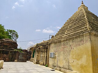
English: Manthani is now a remote small village in Peddapalli district of northeast Telangana. In historic Telugu and Sanskrit texts, it is called Mantrakuta and described as a major religious center with many temples and a large population. This may be, in part, because Manthani is on the southern banks of the Godavari river. These banks and now the farmlands of Manthani have many ruins and littered parts of 10th to 13th-century Kakatiya era Hindu and Jain temples, a legacy of the violence during and after the Islamic invasion of the Deccan region. Along with the scattered broken sections of the demolished temples, the standing interior sections of the temple are defaced or with head, limbs chooped off. Outside the temples, signs of natural erosion as well as vandalism or intentional destruction are visible. Many broken intricately carved sections survive and are littered in this area, like many other parts of Telangana and the Deccan region.
The Gautamesvara temple, also spelled Gautameshwara or Gowthameeshvara or similar phonetic equivalent, is one of seven major ruins found in Manthani area. It is close to the banks of Godavari, along with a few other temples. Some ruins are farther inland towards the contemporary village. The Gautamesvara temple was built during the Kakatiya rule. This is confirmed by the several inscriptions found here. |
Date | |
Source | P. Madhusudan (OTRS 2021070410003731) |
Author | P. Madhusudan |
Camera location | 18° 40′ 13.64″ N, 79° 40′ 49.28″ E | View this and other nearby images on: OpenStreetMap | 18.670456; 79.680356 |
---|
Licensing
Photographs created by P. Madhusudan, Telangaana, India uploaded by User:Ms Sarah Welch are released as CC-0.
This license & permission applies only to the photographs and not to any protected works that might be depicted in the media itself. Unless stated otherwise, the content depicted in the media is in the public domain due to its age.
|
Items portrayed in this file
depicts
18°40'13.642"N, 79°40'49.282"E
30 June 2021
0.00035932446999640675 second
1.7
3.93 millimetre
image/jpeg
File history
Click on a date/time to view the file as it appeared at that time.
Date/Time | Thumbnail | Dimensions | User | Comment | |
---|---|---|---|---|---|
current | 09:25, 9 July 2021 | 4,608 × 3,456 (4.68 MB) | Ms Sarah Welch | Uploaded a work by P. Madhusudan from P. Madhusudan (OTRS 2021070410003731) with UploadWizard |
File usage
Global file usage
The following other wikis use this file:
- Usage on ne.wikipedia.org
Metadata
This file contains additional information, probably added from the digital camera or scanner used to create or digitize it.
If the file has been modified from its original state, some details may not fully reflect the modified file.
Camera manufacturer | samsung |
---|---|
Camera model | SM-J810G |
Exposure time | 1/2,783 sec (0.00035932446999641) |
F-number | f/1.7 |
ISO speed rating | 40 |
Date and time of data generation | 11:36, 30 June 2021 |
Lens focal length | 3.93 mm |
User comments | #Q??\f,?Uz??Uz??~?lL?x??Y`%?HL?xUz??%?H??Y`??CnQAWB1+6dD|@?@ =Y8?;?9(7o/~,b+?!u'y&H1?5?>?=?;?:a7$8h784.?*?)a?"%?2J4^46?636;5(5?2?0?,?*P!???$3?3?3|23C3|2P20/a,r%??r ?q22?1?0?1\1?1\0p/?/?+"?? U? o1`1G1?11?0?/?2?3???6Uy? ^<'2D3?2?;?F?=?)???P?<O?WX23?3w3?3?+?B?
?
??
? ?2t3?2?2J0??M? ??????2?6?6?????Z ???J*? 2@?I+5!] ?'l]??> ? ?h?? ? .?? B??!?!?& ?"s?? !?#?,?#??$?")?%?&U&m?H&?9?7:<?>?<?;.?&L?u$?*D$4?=?9?A,9?D#A?<?3xBj J'?,c ??PuC?v?O????????????q?jkh?Iz^?["u0~????U?P?x?p????{?m,g3d?2rR?X?w?{|%?8??~,}O}?x?s?jqf~C[.jXPxz?x?v?w@xw?vr?o?i?U?&??-wv?t?rBtt?t{r?p?p?g?#????6Lt1t?s?tWs.sUq?w?xo3?!oq"F ??3?[?tw?v????Q`???????T" uIv?wx4y?cW#?)? ??Ik )|6tuvuqt?l+?6??!{#?($!????s?z?w;)G!. ?#?.?-w1?:j &&y??W?d??51?.!3?;v8:5????????7L7I6&9G8#4?0-, ? ?A? 0"?,?>?>?D?5?<L1??=?B9G:>?XB?&?~B???I?C?CAC?2??I?r)p?y_??z?u?X?2?2?2?6]>.h1?9h?{Ct???tH???|?i?z?9?G?N?4?1wPuC?v?O????????????q?jkh?Iz^?["u0~????U?P?x?p????{?m,g3d?2rR?X?w?{|%?8??~,}O}?x?s?jqf~C[.jXPxz?x?v?w@xw?vr?o?i?U?&??-wv?t?rBtt?t{r?p?p?g?#????6Lt1t?s?tWs.sUq?w?xo3?!oq"F ??3?[?tw?v????Q`???????T" uIv?wx4y?cW#?)? ??Ik )|6tuvuqt?l+?6??!{#?($!????s?z?w;)G!. ?#?.?-w1?:j &&y??W?d??51?.!3?;v8:5????????7L7I6&9G8#4?0-, ? ?A? 0"?,?>?>?D?5?<L1??=?B9G:>?XB?&?~B???I?C?CAC?2??I?r)p?y_??z?u?X?2?2?2?6]>.h1?9h?{Ct???tH???|?i?z?9?G?N?4?1wkR?X]i?f?fwb?]Hb?_X[?OXL?K?/&DJAqR?W?c>b?_j^?Z?\?[W?M?IH??:???S9V^V?WTX X?VTW?T?Q?K?Iy&x? <??S?TLS?Q?RYS?R?R"P?NeK5:?? # %NSR?PtOQP^PJQ?P3O?OEI?? > ' .?1LPP?OTP?O*P?O?R?S;?? ???o ?<4P Q7Q?Ydc\?@?G , ?????OJP?Q?Q?R?A\M?Tj?? ? ?"lN?N?NxN$G????????h/L?O?Kn? ?'?OU?^K&?3=?Z?|"$be? |`z???u]?+?? e???O?? 1?g??{?;?$?&h"91| ???7s" ???? '???>}D?GvDh??+ P?? ?8 :?D?@?J*BnMyH'E;?;??!?"c n??n;C~|???g]??E??W???S?????????=6???i??~|???g]??E??W???S?????????=6???i?? @??9j??C??@??7*??mVu?? ??;?S?BC;n??????????????????C 33?@????b?y??@z?.?>(?"???@??7*???S?B.?>(?"????????@??n?>s??.?>(?"?.?>(?"???@??7*??mVu?? ?? @??9j??fF?>??v?U??> ,*?(??>???(??>????&?>X??>?K?+>?>m?8????>\????%?>?K?+>?>(??>???\????%?>m?8????>QCAF??8? vQ(??L? p?u ???S??? ?P/? ?:`Cr? ?? @????/\?:X?c`?b=, ??? ,=&!2 ????Z?b??:????????m???????????m?Z?a???N?j?8???m????u?I?t???????e?L???O? ???P?8????c?O???p??????z? !@QAEC??9?;??;?g;??9f |n??(''g'g'????5??????9d???e?a???????9O?/? %?3E5???fuvyr?? f a!(?1?1?H?H?H?H?H?H?H?H?H?H||||||||||:::::::::;''?3??H?9;|QARV????$??3??E??5$??ft?u?yr$??????????????????????Y\?r?s?t?vssmtf?????????????????????????????????9???????? |
Latitude | 18° 40′ 13.64″ N |
Longitude | 79° 40′ 49.28″ E |
Altitude | 50.3 meters above sea level |
Orientation | Normal |
Horizontal resolution | 72 dpi |
Vertical resolution | 72 dpi |
Software used | J810GDDU2ASB1 |
File change date and time | 11:36, 30 June 2021 |
Y and C positioning | Centered |
Exposure Program | Not defined |
Exif version | 2.2 |
Date and time of digitizing | 11:36, 30 June 2021 |
Meaning of each component |
|
Shutter speed | 11.442 |
APEX aperture | 1.53 |
APEX brightness | 10 |
Exposure bias | 0 |
Maximum land aperture | 1.53 APEX (f/1.7) |
Metering mode | Center weighted average |
Light source | Unknown |
Flash | Flash did not fire |
DateTime subseconds | 000 |
DateTimeOriginal subseconds | 000 |
DateTimeDigitized subseconds | 000 |
Supported Flashpix version | 1 |
Color space | sRGB |
Sensing method | One-chip color area sensor |
Scene type | A directly photographed image |
Exposure mode | Auto exposure |
White balance | Auto white balance |
Focal length in 35 mm film | 26 mm |
Scene capture type | Standard |
Speed unit | Kilometers per hour |
Speed of GPS receiver | 0 |
Reference for direction of image | True direction |
Direction of image | 0 |