Wijhe (Dutch pronunciation: [ˈʋɛiə]) is a village in the Dutch province of Overijssel. It is located in the municipality of Olst-Wijhe and is situated about 12 km south of Zwolle on the banks of the river IJssel.
Wijhe | |
|---|---|
Town | |
 An image of Wijhe | |
 Flag  Coat of arms | |
 Wijhe Location in the province of Overijssel in the Netherlands  Wijhe Wijhe (Netherlands) | |
| Coordinates: 52°23′11″N 6°8′0″E / 52.38639°N 6.13333°E | |
| Country | Netherlands |
| Province | Overijssel |
| Municipality | Olst-Wijhe |
| Area | |
| • Total | 6.43 km2 (2.48 sq mi) |
| Elevation | 3 m (10 ft) |
| Population (2021)[1] | |
| • Total | 6,210 |
| • Density | 970/km2 (2,500/sq mi) |
| Time zone | UTC+1 (CET) |
| • Summer (DST) | UTC+2 (CEST) |
| Postal code | 8131[1] |
| Dialing code | 0570 |
Wijhe was a separate municipality until 2001, when it merged with Olst.[3]
History & Sights edit
The first written record of Wijhe dates from the year 960 as "Wie." The village has a church built in the late-Gothic style, parts of which date from the 13th and 14th century. The windmill in the centre is still in working order. It was built in 1703 and is the oldest eight square mill in the province. To the north of Wijhe lies the hamlet of Herxen with a riverside nature reserve.
Wijhe has three estates: Hengevoorde containing a manor house, Het Nijenhuis with a castle and De Gelder. The last one is the private property of Baron De Vos van Steenwijk, but it is free for public access. Most of the De Gelder castle was destroyed during World War II.
Transportation edit
- Railway station: Wijhe
Gallery edit
-
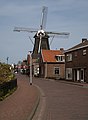 Windmill: the Wijhese Molen
 -
 Villa at the Van Dedemplein


References edit
- ^ a b c "Kerncijfers wijken en buurten 2021". Central Bureau of Statistics. Retrieved 13 April 2022.
- ^ "Postcodetool for 8131AA". Actueel Hoogtebestand Nederland (in Dutch). Het Waterschapshuis. Retrieved 13 April 2022.
- ^ Ad van der Meer and Onno Boonstra, Repertorium van Nederlandse gemeenten, KNAW, 2011.
External links edit
This Overijssel location article is a stub. You can help Wikipedia by expanding it. |