Weimar is a municipality in the south of Marburg-Biedenkopf district in Gießen administrative region, Hesse, Germany. The municipality's administrative seat is the centre of Niederweimar.
Weimar | |
|---|---|
.svg) Coat of arms | |
Location of Weimar within Marburg-Biedenkopf district 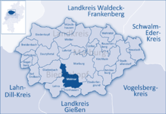 | |
 Weimar  Weimar | |
| Coordinates: 50°45′N 08°42′E / 50.750°N 8.700°E | |
| Country | Germany |
| State | Hesse |
| Admin. region | Gießen |
| District | Marburg-Biedenkopf |
| Government | |
| • Mayor (2022–28) | Markus Herrmann[1] |
| Area | |
| • Total | 47.05 km2 (18.17 sq mi) |
| Highest elevation | 250 m (820 ft) |
| Lowest elevation | 195 m (640 ft) |
| Population (2022-12-31)[2] | |
| • Total | 7,231 |
| • Density | 150/km2 (400/sq mi) |
| Time zone | UTC+01:00 (CET) |
| • Summer (DST) | UTC+02:00 (CEST) |
| Postal codes | 35096 |
| Dialling codes | 06421, 06426 |
| Vehicle registration | MR |
| Website | www |
Geography edit
The municipal area stretches south from Marburg in the Lahn valley and west with the Allna valley on into the Gladenbach Highland and comprises an area of about 47 km². Other than Marburg, the community also borders on Ebsdorfergrund to the east, on Fronhausen to the south, on Lohra to the southwest, and in the far west on the town of Gladenbach.
History edit
The name Weimar is believed to come from the Old Germanic word wih (holy, sanctified) and the Old High German word mar (lake, swamp or moor) put together.
Allna had its first documentary mention as early as 807 and is thereby the earliest named centre in the community. Alongside this, however, Kehna, Oberweimar and Niederweimar, simply from their names, are said to be the oldest centres in the municipal area. The founding of the Martinskirche (church) in Oberweimar is assumed to have happened before Saint Boniface's time, namely about 600, in the time when Irish-Scottish monks were undertaking missionary work in the area.
Over the last few years, as the gravel quarry at Niederweimar has been expanded, great Neolithic settlements have been found, which have since been kept in protective pits.
Earlier divisions edit
_-_Ortsteile.jpg)
Before the current community was founded, the places within it belonged to court regions (Gerichtsbezirke) which also had administrative functions. Allna, Oberweimar, Weiershausen, Kehna, Nesselbrunn, Niederwalgern and Wolfshausen belonged to the Gericht Reizberg. The Reizberg court itself was built on a mountain lying near Oberweimar. Argenstein, Wenkbach and Roth were grouped into the Gericht Schenkisch Eigen of the Schenken (≈stewards) of Schweinsberg. Stedebach was under the Teutonic Knights' ownership while Niederweimar was a landgrave's personal court region (Eigengericht).
Greater Weimar community edit
At its founding on 1 January 1971, the community of Weimar consisted of Allna (half-timbered church), Niederweimar (Weimar Lake) and Oberweimar (Evangelical church). On 1 July 1972, after much drawn-out procedural business, Roth (renovated synagogue), Weiershausen and Wenkbach (Evangelical Wehrkirche – a church built to look like a fort – and Catholic church) joined the community. As a result of Hesse's municipal reforms on 1 July 1974, the community was enlarged by having Argenstein (mill), Kehna (court ensemble), Nesselbrunn, Niederwalgern (Wehrkirche), Stedebach and Wolfshausen added to it.
Politics edit
Municipal council edit
The local elections on 6 March 2016 [3] and formerly on 27 March 2011 yielded the following results:[4]
| Parties and voting blocks | % 2016 |
Seats 2016 |
% 2011 |
Seats 2011 |
% 2006 |
Seats 2006 | |
|---|---|---|---|---|---|---|---|
| SPD | Social Democratic Party of Germany | 34.94 | 8 | 35.1 | 11 | 35.0 | 11 |
| CDU | Christian Democratic Union | 26.05 | 6 | 29.1 | 9 | 35.2 | 11 |
| FBW | Freie Bürgerliste Weimar (citizens' coalition) | 23.71 | 6 | 15.9 | 5 | 14.6 | 4 |
| Greens | Alliance '90/The Greens | 9.2 | 2 | 14.7 | 4 | 8.6 | 3 |
| FDP | Free Democratic Party | 6.11 | 1 | 5.1 | 2 | 6.6 | 2 |
| Total | 100 | 23 | 100 | 31 | 100 | 31 | |
| Turnout in % | 54.03 | 56.4 | 55.5 | ||||
Mayor edit
The mayor of the town of Weimar (Lahn) since 2010 has been Peter Eidam (Independent).[5] Volker Muth (SPD) was mayor from 2004 to 2010. He was followed by Karl Krantz (CDU), who had held the position since the founding of the municipality.
Coat of arms edit
The community's coat of arms might be described thus: Party per pale gules and argent, a rose counterchanged. The arms were bestowed on Weimar twice, on 25 January 1971 and again on 2 July 1975. The rose was chosen to stand for the community's flourishing.[6]
Community partnerships edit
 Sawtry, Huntingdonshire, United Kingdom
 Wutha-Farnroda, Thuringia
 Slupca, Poland since 2005 (officially since July 2006)[7]
Culture and sightseeing edit
Buildings edit


Among other buildings in the community worth seeing are the "fortress church" in Wenkbach and churches in Niederweimar, Niederwalgern, Allna and Roth. The watermill in Argenstein and the synagogue in Roth are also worth a visit, as are the half-timbered houses to be found in some centres.
Music edit
Various clubs in the constituent communities offer a range of different kinds of music. As well as several singing clubs and choirs, there are all kinds of music clubs in Weimar, even a trombone choir and the Wenkbach civic and cultural club's orchestra.
Sport edit
The community's biggest sport clubs are the SG Niederwalgern/Wenkbach, the SC Roth/Argenstein and the TSV Niederweimar. In football, the clubs from Niederwalgern, Wenkbach, Roth and Argenstein form an association and compete as FSG Südkreis. The TSV (Turn- und Sportverein, that is, gymnastic and sport club) Niederweimar has its own team. Other sports have clubs, too: tennis is offered, for example, at SG Niederwalgern/Wenkbach as well as at TV Weimar in Wolfshausen. Table tennis can be played in, among other places, in Wenkbach in the department specially set up for it at the civic and cultural club.
Economy and infrastructure edit
Economy edit
The community's biggest industrial park is found in the southern end of Wenkbach. The firms YKK und Pauly are located there. Scattered throughout the other centres are further businesses, mostly small and in handicrafts.
Transport edit
Through the community run two Federal Highways, Bundesstraße 3 from Marburg to Gießen, which has still not been built into a four-lane highway, and Bundesstraße 255 going towards Gladenbach and Herborn. Niederwalgern station and Niederweimar station are stops on the Main-Weser Railway between Kassel and Frankfurt am Main at which stop regional and regional express trains (the latter only in Niederwalgern). Various buslines join the community's several centres together and to neighbouring communities.
Leisure edit
Smaller facilities such as playgrounds can be found in most of the constituent communities, but the only facility well known outside the region is the Seepark ("lake park"), offering a lake with swimming and a recreational area.
Famous inhabitants edit
- Walter Schlesinger (1908-1984) - famous historian, lived and died in Wolfshausen
- Dirk Wolf (1972- ) - footballer, formerly with, among others, Eintracht Frankfurt, grew up in Argenstein
References edit
- ^ "Ergebnisse der jeweils letzten Direktwahl von Landrätinnen und Landräte sowie (Ober-)Bürgermeisterinnen und (Ober-)Bürgermeister in Hessen, Stand 13.04.2023" (XLS) (in German). Hessisches Statistisches Landesamt.
- ^ "Bevölkerung in Hessen am 31.12.2022 nach Gemeinden" (XLS) (in German). Hessisches Statistisches Landesamt. June 2023.
- ^ Official statistics of municipality
- ^ "Endgültiges Ergebnis der Gemeindewahl am 27. März 2011, Weimar (Lahn)" (in German). Hessian Statististical Office. Retrieved 8 July 2012.
- ^ "Neuer Bürgermeister – alte Mittagspause-Zeiten". Oberhessische Presse (in German). 30 December 2010. Retrieved 8 July 2012.
- ^ "Deutsche Wappen (Gemeindewappen Kreiswappen) - WEIMAR (Lahn)". Archived from the original on 2003-09-14.
- ^ Partnerships of Weimar (Lahn) community website