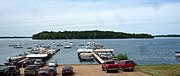
Waconia (/wəˈkoʊnjə/ wə-KOHN-yə or /wəˈkoʊniə/ wə-KOH-nee-ə)[4] is a city in Carver County, Minnesota, United States. Waconia attracts visitors to nearby Lake Waconia, a lake locally renowned for its fishing and recreation opportunities.
Waconia | |
|---|---|
 View of Lake Waconia | |
 Location of the city of Waconia within Carver County, Minnesota | |
| Coordinates: 44°50′29″N 93°47′24″W / 44.84139°N 93.79000°W | |
| Country | United States |
| State | Minnesota |
| County | Carver |
| Government | |
| • Mayor | Nicole Waldron[1] |
| Area | |
| • Total | 5.31 sq mi (13.76 km2) |
| • Land | 5.28 sq mi (13.67 km2) |
| • Water | 0.04 sq mi (0.09 km2) |
| Elevation | 981 ft (299 m) |
| Population (2020) | |
| • Total | 13,033 |
| • Density | 2,468.84/sq mi (953.23/km2) |
| Time zone | UTC-6 (Central (CST)) |
| • Summer (DST) | UTC-5 (CDT) |
| ZIP code | 55387 |
| Area code | 952 |
| FIPS code | 27-67432 |
| GNIS feature ID | 2397159[3] |
| Website | www |
The city's population was 13,033 at the 2020 census.[5]
Geography edit

According to the United States Census Bureau, the city has a total area of 4.39 square miles (11.37 km2), of which 4.34 square miles (11.24 km2) is land and 0.05 square miles (0.13 km2) is water.[6]
Minnesota State Highways 5 and 284; and Carver County Highway 10 are the main routes in Waconia.
Demographics edit
| Census | Pop. | Note | %± |
|---|---|---|---|
| 1880 | 218 | — | |
| 1890 | 441 | 102.3% | |
| 1900 | 728 | 65.1% | |
| 1910 | 817 | 12.2% | |
| 1920 | 901 | 10.3% | |
| 1930 | 1,291 | 43.3% | |
| 1940 | 1,315 | 1.9% | |
| 1950 | 1,569 | 19.3% | |
| 1960 | 2,048 | 30.5% | |
| 1970 | 2,445 | 19.4% | |
| 1980 | 2,638 | 7.9% | |
| 1990 | 3,498 | 32.6% | |
| 2000 | 6,814 | 94.8% | |
| 2010 | 10,697 | 57.0% | |
| 2020 | 13,033 | 21.8% | |
| U.S. Decennial Census[7] | |||

2000 census edit
As of the census[8] of 2000, there were 6,814 people, 2,568 households, and 1,848 families living in the city. The population density was 2,432.0 inhabitants per square mile (939.0/km2). There were 2,646 housing units at an average density of 944.4 per square mile (364.6/km2). The racial makeup of the city was 97.06% White, 0.34% African American, 0.12% Native American, 0.65% Asian, 0.01% Pacific Islander, 1.00% from other races, and 0.82% from two or more races. Hispanic or Latino of any race were 1.28% of the population.
There were 2,568 households, out of which 40.7% had children under the age of 18 living with them, 61.0% were married couples living together, 7.8% had a female householder with no husband present, and 28.0% were non-families. 23.3% of all households were occupied by one person and 12.2% had someone living alone who was 65 years of age or older. The average household size was 2.62 and the average family size was 3.12.
The city population had a wide age variety; with 29.9% being under the age of 18, 5.8% from 18 to 24, 35.5% from 25 to 44, 16.3% from 45 to 64, and 12.4% who were 65 years of age or older. The median age was 33 years. For every 100 females, there were 91.1 males. For every 100 females age 18 and over, there were 89.5 males.
The median income for a household in the city was $55,705, and the median income for a family was $67,703. Males had a median income of $43,535 versus $29,488 for females. The per capita income for the city was $26,996. About 2.9% of families and 3.8% of the population were below the poverty line, including 3.7% of those under age 18 and 9.5% of those age 65 or over.
2010 census edit
As of the census[9] of 2010, there were 10,697 people, 3,909 households, and 2,748 families living in the city. The population density was 2,464.7 inhabitants per square mile (951.6/km2). There were 4,112 housing units at an average density of 947.5 per square mile (365.8/km2). The racial makeup of the city was 95.7% White, 1.1% African American, 0.3% Native American, 1.1% Asian, 0.7% from other races, and 1.1% from two or more races. Hispanic or Latino of any race were 2.5% of the population.
There were 3,909 households, of which 45.2% had children under the age of 18 living with them, 60.1% were married couples living together, 7.1% had a female householder with no husband present, 3.0% had a male householder with no wife present, and 29.7% were non-families. 25.6% of all households were made up of individuals, and 12% had someone living alone who was 65 years of age or older. The average household size was 2.70 and the average family size was 3.31.
The median age in the city was 34.9 years. 32.5% of residents were under the age of 18; 5% were between the ages of 18 and 24; 30.7% were from 25 to 44; 20.7% were from 45 to 64; and 11.3% were 65 years of age or older. The gender makeup of the city was 48.4% male and 51.6% female.
Economy edit
Top employers edit
According to the city's 2019 Comprehensive Annual Financial Report (CAFR),[10] the top employers in the city are:
| # | Employer | # of Employees |
|---|---|---|
| 1 | Ridgeview Medical Center | 1,623 |
| 2 | Strom Aviation | 1,001 |
| 3 | I.S.D. No. 110 (Waconia Schools) | 969 |
| 4 | ACPI Products | 500 |
| 5 | Mackenthun's Fine Foods | 200 |
| 6 | Physicians Service Network | 200 |
| 7 | Good Samaritan Society Waconia | 158 |
| 8 | Target | 150 |
| 9 | Lakeview Clinic | 120 |
| 10 | UFC Farm Supply | 120 |
Politics edit
| Year | Republican | Democratic | Third parties |
|---|---|---|---|
| 2020 | 52.3% 4,132 | 45.3% 3,580 | 2.4% 186 |
| 2016 | 53.9% 3,501 | 36.7% 2,383 | 9.4% 609 |
| 2012 | 59.1% 3,548 | 39.0% 2,342 | 1.9% 110 |
| 2008 | 57.2% 3,177 | 41.3% 2,292 | 1.5% 82 |
| 2004 | 62.8% 3,073 | 36.5% 1,788 | 0.7% 34 |
| 2000 | 48.7% 1,341 | 45.5% 1,254 | 5.8% 160 |
| 1996 | 41.8% 924 | 45.3% 1,002 | 12.8% 287 |
| 1992 | 40.5% 833 | 32.1% 661 | 27.4% 562 |
| 1988 | 58.2% 939 | 41.8% 675 | 0.0% 0 |
| 1984 | 65.5% 865 | 34.5% 455 | 0.0% 0 |
| 1980 | 52.2% 751 | 39.7% 571 | 8.1% 117 |
| 1976 | 54.5% 727 | 43.3% 577 | 2.2% 30 |
| 1968 | 52.5% 627 | 44.3% 529 | 3.2% 38 |
| 1964 | 52.4% 582 | 47.4% 527 | 0.2% 2 |
| 1960 | 58.5% 614 | 41.5% 435 | 0.0% 0 |
Education edit
Waconia Public Schools operates five schools. There are also two private schools within Waconia to make seven total:
- Southview Elementary, grades K–5
- Bayview Elementary, grades K–5
- Laketown Elementary, grades K-5
- Waconia Middle School, grades 6–8
- St. Joseph Catholic Education Center, grades PreK–8
- Trinity Lutheran School, grades K–8
- Waconia High School, grades 9–12
History edit
A post office has been in operation at Waconia since 1860.[12] The city took its name from Lake Waconia.[13]
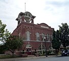
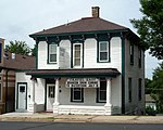
National Register of Historic Places gallery edit
Waconia has several buildings listed on the National Register of Historic Places (see: National Register of Historic Places listings in Carver County, Minnesota). One of the more prominent listings is for Coney Island of the West on Lake Waconia, where cottages, boathouses and resort hotels attracted tourists, especially from 1884 until the late 1920s, when the rise of the automobile allowed people to travel farther away for summer vacations.[14]
-
-
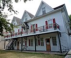
 West Main Street Houses, from left to right 417, 429, and 453 W. Main St.
 -
 Emile Amblard Guest House
 -
 Coney Island of the West on Lake Waconia across from Waconia
 -
 Mock Cigar Factory and House
 -
 Charles Maiser House


Popular culture edit
- In the film Drop Dead Gorgeous, 1st Street near St. Joseph's Catholic Church in Waconia is used when the swan float explodes in the parade.[15][16]
Notable people edit
- Robert O. Ashbach, Minnesota state legislator and businessman
- Jenn Bostic, singer and songwriter
- Bill Diessner, Minnesota state legislator and physician
- Aaron Elling, football player
- Don Herbert, Mr. Wizard and host of Mr. Wizard's World
- Noah McCourt, politician, disability advocate and speaker
- Susie Schmitt Hanson, (1860–1956) milliner, dressmaker and entrepreneur
- Bob Stinson, musician, lead guitarist for The Replacements
- Henry Wagener, Minnesota state legislator and farmer
- Maxx Williams, NFL tight end for the Arizona Cardinals, was born in Waconia
- Shane Wiskus, artistic gymnast, represented Team USA at the 2020 Summer Olympics
References edit
- ^ "Metro briefs: Washington County buys land to expand regional park in Denmark Township". Star Tribune.
- ^ "2020 U.S. Gazetteer Files". United States Census Bureau. Retrieved July 24, 2022.
- ^ a b U.S. Geological Survey Geographic Names Information System: Waconia, Minnesota
- ^ "Minnesota Pronunciation Guide". Associated Press. Archived from the original on July 22, 2011. Retrieved July 4, 2011.
- ^ "U.S. Census Bureau". Retrieved August 17, 2021.
- ^ "US Gazetteer files 2010". United States Census Bureau. Retrieved November 13, 2012.
- ^ United States Census Bureau. "Census of Population and Housing". Retrieved November 21, 2014.
- ^ "U.S. Census website". United States Census Bureau. Retrieved January 31, 2008.
- ^ "U.S. Census website". United States Census Bureau. Retrieved November 13, 2012.
- ^ "Audited Financial Statement 2019 (PDF)". City of Waconia, Minnesota. Retrieved June 8, 2021.
- ^ "Minnesota Elections: Dates and Vote Totals". Minnesota Legislative Reference Library. Retrieved June 14, 2021.
- ^ U.S. Geological Survey Geographic Names Information System: Waconia Post Office
- ^ Upham, Warren (1920). Minnesota Geographic Names: Their Origin and Historic Significance. Minnesota Historical Society. p. 84.
- ^ "Coney Island of the West, 1884–1960," Minnesota Historical Society
- ^ Tschida, Mary Kate (April 24, 2018). "The Best MN-Made Flicks and Where They Were Filmed". MinnesotaMonthly.com. The Spirit of Minnesota. Retrieved June 9, 2021.
- ^ "Drop Dead Gorgeous (1999) Filming & Production". IMDb.com. IMDb. Retrieved June 9, 2021.