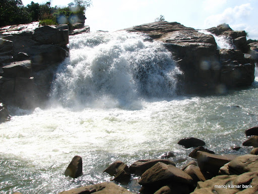
Usri Falls is a waterfall located in Giridih district in the Indian state of Jharkhand. It is a popular tourist and picnic spot.[1][2][3] Ushree means a "beautiful source".
| Usri Falls | |
|---|---|
 Ushri falls | |
 Usri Falls | |
 | |
| Location | Giridih district, Jharkhand, India |
| Coordinates | 24°5′47″N 86°22′14″E / 24.09639°N 86.37056°E |
| Elevation | 288 metres (945 ft) |
| Total height | 12 metres (39 ft) |
| Number of drops | 3 |
| Watercourse | Usri River |
Geography edit


10miles
Dham
River
River
M: municipality, CT: census town, R: rural/ urban centre, H: historical/ religious/ tourist centre
Owing to space constraints in the small map, the actual locations in a larger map may vary slightly
Location edit
Usri Falls is located 13 kilometres (8.1 mi) east of the Giridih town on the road to Tundi.[3] Taxis, tongas and auto-rickshaws are available.[1][4][5]
Note: The map alongside presents some of the notable locations in the district. All places marked in the map are linked in the larger full screen map.
Description edit
The Usri River, a tributary of the Barakar River, flows down a steep gorge. The Usri Falls drop some 12 metres (39 ft) in three separate streams. It is surrounded by dense forest.[4]
The character of the gneissic complex of this region is well exposed. Some of the rocks have been split up into blocks of huge dimension whose polished and clean surfaces have been chequered by veins of various hues. The profile of the river bed changes after passing through the falls. The lower portion is mostly flat, slightly undulating, which gives way to gorge like form.[6] The government has taken several steps to develop the area as a prominent tourist spot along with Khandoli Dam and Parasnath.[7][8]
See also edit
- List of waterfalls in India
- List of waterfalls in India by height
 Giridih travel guide from Wikivoyage
References edit
- ^ a b "Giridih Tourism". Official Website of Giridih. Retrieved 7 March 2012.
- ^ "Jharkhand Fast Facts". Jharkhand. Envis Centre on Ecotourism, Govt of India. Archived from the original on 7 February 2012. Retrieved 7 March 2012.
- ^ a b Dr. B.R. Kishore, Dr. Shiv Sharma (2008). India - A Travel Guide. Diamond Pocket Books (P) Ltd. p. 302. ISBN 9788128400674.
- ^ a b "Giridih attractions". sulekha.com. Retrieved 17 April 2010.
- ^ "Usri Falls". india9.com. Retrieved 20 April 2010.
- ^ Sharma, Hari Shanker. Perspectives in geomorphology, Volume 1 By Hari Shanker Sharma. Retrieved 17 April 2010.
- ^ "Ire over park entry fee". The Telegraph (Calcutta). 10 January 2008. Archived from the original on 4 March 2016. Retrieved 9 March 2012.
- ^ Prasad, Basudeo (1 January 2009). "Sustainable eco-tourism development: A case study of Jharkhand state". Spectrum. 1 (1): 62. Retrieved 6 April 2012.
External links edit
| External images | |
|---|---|
| External videos | |
|---|---|
This article related to a location in Jharkhand is a stub. You can help Wikipedia by expanding it. |