
| This is a Wikipedia user page. This is not an encyclopedia article or the talk page for an encyclopedia article. If you find this page on any site other than Wikipedia, you are viewing a mirror site. Be aware that the page may be outdated and that the user whom this page is about may have no personal affiliation with any site other than Wikipedia. The original page is located at https://en.wikipedia.org/wiki/User:Olahus. |

Beliefs
|

| |||
Hi! I am the user Olahus. I am interested in the history and geography of Central, Eastern and Southeastern Europe.
I am a registered user since May 2006.
_with_dragonflies.jpg)
The European bee-eater (Merops apiaster) is a bird in the bee-eater family, Meropidae. It breeds in southern and central Europe, northern and southern Africa, and western Asia. Except for the resident southern African population, the species is strongly migratory, wintering in tropical Africa. This species, like other bee-eaters, is a richly coloured, slender bird. It has brown and yellow upper parts, whilst the wings are green and the beak is black. It can reach a length of 27–29 cm (10.6–11.4 in), including the two elongated central tail feathers. The most important prey item in its diet is Hymenoptera, mostly the European honey bee. Its impact on bee populations, however, is small. It eats less than 1% of the worker bees in areas where it lives. This group of three European bee-eaters, each with a dragonfly in its mouth, was photographed in Kondor Tanya, Kecskemét, Hungary.Photograph credit: Charles J. Sharp
Images uploaded by me edit
Maps created by me edit

.PNG)
.PNG)
.PNG)
.PNG)
.PNG)


.png)

.PNG)
.PNG)
.PNG)


.PNG)


Scanned images edit
-
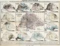
 Ethnic map of the Balkan Peninsula (1898)
 -
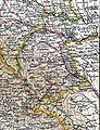
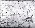
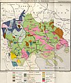
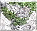
 The Austrian Empire during the XVII century
 -
 The Carolingian Empire after the Treaty of Verdun
 -
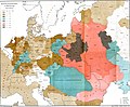
 Ethnic map of European Russia before the First World War
 -
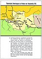
 Ethnographic map of Dobruja (1918)
 -
 The Principality of Montenegro in 1862
 -
 Major Lithuanian linguistic areal in 1876.
 -
 Ethnic Germans in Hungary and parts of adjacent Austrian territories, census 1890
 -
 Demographic map of Italy and surroundung regions (1859)
 -
 Linguistic map of Slovenia and surrounding regions (census 1880)
 -
 Linguistic map of Istria (census 1880)
 -
 The Romanian Old Kingdom (1901)
 -
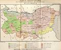
 Bulgaria in 1901
 -
 General map of Rumania (1967)
 -
 Confessions in Central Europe
 -
 Bukovina in 1901
 -
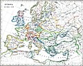
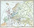 Political map of Europe (1899)
 -
 Political map of Asia (1899)
 -
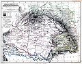
 Main subdivisions of Austria-Hungary (1899).
 -
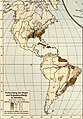
 Political map of South America (1899)
 -
 Extermination of the American Bison to 1889
 -
 The density of the railway net in Europe (1902)
 -
 Map of Greece and European Turkey (1829)
 -
-
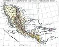
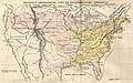 The United States in 1829
 -
 Europe in 1828
 -
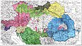
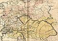 Austria-Hungary in 1828
 -
 The German confederation (1828)
 -
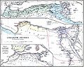
 The Ottoman Empire in Asia (1829)
 -
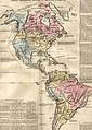 The American continent in 1828
 -
 Africa in 1828
 -
 Asia in 1829
 -
 The Russian Empire in 1828
 -
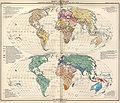
 The world map (1829)
 -
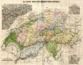 Historical map of Switzerland
 -
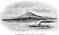
 The Lake Lucerne (1829)
 -
-

-

-

-

-
-

-

-
-

-
-

-
-
-

-

-
-
-

-

-
-

-

-

-

-
-
-
-

-

-
-
-

-

-
-
-
-

-
-

-
-

-

-
-

-

-

-

-

-
-
-

-

-
-

-

-
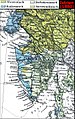
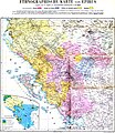 Ethnographic map of the Epirus region, 1878. Greek point of view
 -
 Walser settlements in northwestern Italy


.JPG)

.JPG)


.jpg)
.JPG)


.JPG)


.JPG)
.jpg)
.JPG)


.JPG)


_1892.JPG)

.JPG)
.jpg)

.JPG)


.jpg)

.JPG)

.jpg)


.JPG)
.jpg)

.jpg)
.jpg)


.jpg)


.JPG)


