Southernmost settlements are cities, towns, weather stations or permanent military bases which are farther south than latitude 45°S. They are closely related to the Southern Ocean or either the Roaring Forties or Furious Fifties. Antarctic bases are excluded due to not having a permanent population.

Unlike the northern hemisphere, where a large number of major cities including London, Paris, Amsterdam, Berlin, Vienna, Prague and Budapest are all located north of the 45°N parallel, the only permanently populated areas south of the 45°S parallel are the small and sparsely populated regions of southern Patagonia in South America, the Falkland Islands, and the southernmost tip of New Zealand.
Southernmost city edit
The southernmost city in the world is mainly a slogan used for tourism purposes to attract visitors to a city as well as the tourists headed for Antarctica. Ciudad (city) is not a legal designation in Chile and Argentina, except for the Autonomous City of Buenos Aires. Currently, three places use this slogan: Ushuaia in Argentina as well as Punta Arenas and Puerto Williams[1][2][3][4][5][6][7][8] in Chile, with the last being the absolute southernmost town by latitude (see table below). There are several more settlements further south but none are considered to be large enough to be classified as a 'city'. The three contending cities are from north to south:
- Punta Arenas (53°10′S 70°56′W / 53.167°S 70.933°W, population: 123,403), literally in Spanish: "Sandy Point", is the oldest and largest city in Southern Patagonia, at the Strait of Magellan and the capital of the Magallanes and Antártica Chilena Region. It is the largest of the three contenders with around 130,000 permanent residents[9] and it is called the southernmost city by some media outlets. The basis of its claim to be the southernmost city rests on it being larger than Ushuaia, Río Grande, and Puerto Williams, all of which are farther south.
- Ushuaia (54°48′S 68°18′W / 54.800°S 68.300°W, population: 82,615), the capital of the Argentine province of Tierra del Fuego, is more commonly regarded as the southernmost city in the world due to its sufficiently large population, its infrastructure, and its accepted classification as a city.[10][11][12] Ushuaia is located in a wide bay on the southern coast of the island of Tierra del Fuego, on the northern shore of the Beagle Channel; hence, it is further north than Puerto Williams.
- Puerto Williams (54°56′S 67°37′W / 54.933°S 67.617°W, population: 1,868), located on Isla Navarino, is the southernmost town in the world on the southern shore of the Beagle Channel. It is the capital of the Antártica Chilena Province, one of four provinces located in the Magallanes and Antártica Chilena Region.[13] Puerto Williams is sometimes considered the southernmost city in the world by Chilean media and some large media international organisations,[14][15][16][2][3][4][5][6][7] although it promotes itself with the slogan Puerto Williams, the southernmost town in the world[8] in its tourism campaigns. It has a Naval Hospital of Puerto Williams, the Martin Gusinde Anthropological Museum, the Guardiamarina Zañartu Airport and a university campus and it is a naval base of the Chilean Navy.
-

-
 Punta Arenas city view
 -
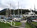 Puerto Williams, Micalvi yacht club


Settlements of more than 1,000 inhabitants south of 45°S edit
.svg)
This is a list of all settlements south of the 45th parallel south with over 1,000 permanent inhabitants.
Southernmost settlements outside Antarctica edit
This list of settlements excludes research stations in Antarctica and its surrounding islands.
| # | Location | Country | Settlement type |
Latitude | Population | Population as of | Köppen climate classification |
|---|---|---|---|---|---|---|---|
| 1 | Estación Naval Islas Diego Ramirez |
Chile | Naval station | 56°30′ S | 4 | 2017 | ET |
| 2 | Estación Meteorológica de Cabo de Hornos |
Chile | Weather station | 55°59′ S | 4[19] | 2008 | ET |
| 3 | Puerto Toro | Chile | Hamlet | 55°05′ S | 36[20] | 2002 | ET |
| 4 | Caleta Wulaia | Chile | Hamlet | 55°02′ S | ? | ? | ET |
| 5 | Caleta Eugenia | Chile | Hamlet | 54°56′ S | ? | ? | ? |
| 6 | Puerto Williams | Chile | Town | 54°56′ S | 1,868[17] | 2002 | Cfc |
| 7 | Puerto Navarino | Chile | Village | 54°55′ S | ? | ? | Cfc |
| 8 | Puerto Almanza | Argentina | Village | 54°52′ S | 200 | ? | Cfc |
| 9 | Ushuaia | Argentina | City | 54°48′ S | 82,615[18] | 2010 | Cfc |
| 10 | Tolhuin | Argentina | Town | 54°31′ S | 9,879[18] | ? | Cfc |
| 11 | Macquarie Island Station | Australia | Scientific research station | 54°30′ S | 20 to 40 | ? | ET |
| 12 | Grytviken | South Georgia and the South Sandwich Islands | Hamlet | 54°19′ S | up to 18 | ? | ET |
| 13 | Río Grande | Argentina | City | 53°45′ S | 98,017[18] | 2010 | Cfc/Dfc |
| 14 | Porvenir | Chile | Town | 53°17′ S | 5,465 | ? | Cfc |
| 15 | Punta Arenas | Chile | City | 53°17′ S | 123,403[17] | 2002 | Cfc |
- The former Argentine base Corbeta Uruguay (59°28′ S) in South Sandwich Islands was the southernmost settlement outside Antarctica from 1976–1982.
Settlements on the Antarctic continent edit
There are many research stations in Antarctica, both permanent and summer only. Many of the stations are staffed all year. McMurdo Station is the largest with an average population of 1200.
A total of 30 countries (as of October 2006), all signatory to the Antarctic Treaty, operate seasonal (summer) or year-round research stations on the continent and on its surrounding islands. In addition to these permanent stations, approximately 30 field camps are established each austral summer to support specific one off projects.[21]
The full list is available at: Research stations in Antarctica.
See also edit
References edit
- ^ "Ushuaia ya no será la ciudad más austral del mundo". 30 June 1998. Retrieved 1 November 2014.
- ^ a b "Puerto Williams: ubicada entre Tierra del Fuego por el norte y el Cabo de Hornos por el sur , por lo tanto es la cuidad mas Austral del país y del mundo". Archived from the original on 2016-03-04. Retrieved 2012-06-16.
- ^ a b http://www.infinito-sur.com/ Archived 2013-04-22 at the Wayback Machine, retrieved 9 April 2012
- ^ a b Puerto Williams espera una gran temporada de centolla[permanent dead link], retrieved 9 April 2012
- ^ a b Escritorio Estudiantes Archived 2009-02-28 at the Wayback Machine, retrieved 9 April 2012
- ^ a b dibam, retrieved 9 April 2012
- ^ a b Times Online
- ^ a b Website thisischile.cl Puerto Williams, the southernmost town in the world
- ^ Interactive map, INE Census 2002, Chile. (Click on XII Region and then on Punta Arenas)
- ^ Boston Globe 2008
- ^ "Tierra del Fuego, Argentina". Encarta. Archived from the original on 2008-12-06. Retrieved 2008-09-11.
- ^ "Ushuaia". Britannica. Retrieved 2009-05-23.
- ^ WillySol. "Puerto Williams - Chile". Retrieved 1 November 2014.
- ^ "Una localidad chilena le roba a Ushuaia la etiqueta de ciudad más austral del mundo". 29 May 2019.
- ^ "Por qué Ushuaia perdió el título de "la ciudad más austral del mundo"". 30 May 2019.
- ^ "Argentinos admiten derrota: Reconocen a Puerto Williams como la ciudad más austral del mundo". 30 May 2019.
- ^ a b c d "Ciudades, pueblos, aldeas y caseríos 2019" (pdf) (in Spanish). Instituto Nacional de Estadísticas (Chile). March 2019. p. 132. Retrieved October 17, 2023.
- ^ a b c d e f "Censo Nacional de Población, Hogares y Viviendas 2022. Resultados provisionales" (pdf). Censo 2022. República Argentina (in Spanish). Buenos Aires: Instituto Nacional de Estadística y Censos (INDEC). January 2023. p. 32. Retrieved 2023-10-17.
- ^ "Vida al fin del mundo: Una familia chilena haciendo soberanía en Cabo de Hornos". Emol. Retrieved 1 November 2014.
- ^ "DEMOGRAFÍA". Retrieved 1 November 2014.
- ^ 4.0 Antarctica – Past and Present
Bibliography edit
- L. Ivanov and N. Ivanova. Southernmost city. In: The World of Antarctica. Generis Publishing, 2022. pp. 126-130. ISBN 979-8-88676-403-1