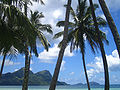
Taravai is the second largest island in the Gambier Islands archipelago of French Polynesia, at 5.7 km2. Taravai is about 1.5 km southwest of Mangareva, the largest island of the whole Gambier group, and about 300 m north of the island of Angakauitai. Off its eastern shore lies the tiny rock Îlot Motu-o-ari.
 View of Taravai | |
 Taravai | |
| Geography | |
|---|---|
| Location | Pacific Ocean |
| Coordinates | 23°08′12″S 135°01′33″W / 23.13667°S 135.02583°W |
| Archipelago | Tuamotus |
| Area | 5.7 km2 (2.2 sq mi) |
| Highest elevation | 256 m (840 ft) |
| Highest point | (unnamed) |
| Administration | |
France | |
| Overseas collectivity | French Polynesia |
| Administrative subdivision | Tuamotus |
| Commune | Gambier Islands |
| Largest settlement | Agonoko |
| Demographics | |
| Population | 9[1] (2012) |
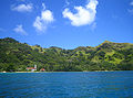
The village named Agonoko is located near the main bay on the island's eastern shore. It has a population of 9 (as of 2012[update]). Former villages were Aga-nui (northwest) and Agakau-i-uta (southeast).[2]
The Onemea archaeological site suggests sporadic occupation of the island around AD 950 with a possible continuous settlement since the 13th century.[3]
Before the conversion to Christianity, the king of Taravai was a vassal to the king of Rikitea in Mangareva.[4]
-
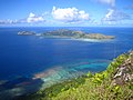 View of Taravai and Angakauitai from Mont Mokoto
 -
 Church of Saint-Gabriel
 -
-
 Taravai


References edit
- ^ "Population". Institut de la statistique de la Polynésie française. Retrieved 14 October 2014.
- ^ Goodbye Gambiers
- ^ The Onemea site (Taravai Island, Mangareva) and the human colonization of Southeastern Polynesia. Archaeology in Oceania
- ^ R. W. Williamson, The Social and Political Systems of Central Polynesia, Cambridge University Press, 1924
External links edit
This French Polynesia-related geography article is a stub. You can help Wikipedia by expanding it. |