Monts-sur-Orne (French pronunciation: [mɔ̃ syʁ ɔʁn]) is a commune in the department of Orne, northwestern France. The municipality was established on 1 January 2018 by merger of the former communes of Goulet (the seat), Montgaroult and Sentilly.[3]
Monts-sur-Orne | |
|---|---|
 The church and war memorial in Goulet | |
Location of Monts-sur-Orne  | |
 Monts-sur-Orne  Monts-sur-Orne | |
| Coordinates: 48°44′01″N 0°05′30″W / 48.7336°N 0.0917°W | |
| Country | France |
| Region | Normandy |
| Department | Orne |
| Arrondissement | Argentan |
| Canton | Magny-le-Désert |
| Intercommunality | Argentan Intercom |
| Government | |
| • Mayor (2020–2026) | Gilles Mallet[1] |
| Area 1 | 30.90 km2 (11.93 sq mi) |
| Population (2021)[2] | 873 |
| • Density | 28/km2 (73/sq mi) |
| Time zone | UTC+01:00 (CET) |
| • Summer (DST) | UTC+02:00 (CEST) |
| INSEE/Postal code | 61194 /61150 |
| 1 French Land Register data, which excludes lakes, ponds, glaciers > 1 km2 (0.386 sq mi or 247 acres) and river estuaries. | |
Population edit
The former commune of Sentilly had a 2019 population of 128.[4]
Geography edit
The commune is made up of the following collection of villages and hamlets, Goulet, Pommereux, Montgaroult, Sentilly, Vaux le Bardoult, Fontaine and Vloger. It also borders the area known as Suisse Normande.[5][6]
The commune has two rivers running through it, the River Orne and one of its tributaries the River Houay.[7][8]
Points of Interest edit
National Heritage sites edit
The Commune has three buildings and areas listed as a Monument historique.[11]
- Servin Cross is a 13th century Wayside cross located in Goulet that was listed as a Monument historique in 1955.[12]
- Vaux-le-Bardoult Church is a 14th Century Church located in Vaux le Bardoult that was registered as a Monument in 1972.[13]
- Manoir de Pommereux is a 15th Century manor house located in Pommereux that was listed as a Monument historique in 1926.[14]
-
 Manoir de Pommereux
 -
 Vaux-le-Bardoult church
 -
 Servin Cross
 -
 Montgaroult church
 -
 War Memorial in Goulet
 -
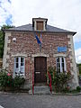 Sentilly Mayors office


_mairie.JPG)
See also edit
References edit
- ^ "Répertoire national des élus: les maires" (in French). data.gouv.fr, Plateforme ouverte des données publiques françaises. 13 September 2022.
- ^ "Populations légales 2021". The National Institute of Statistics and Economic Studies. 28 December 2023.
- ^ Arrêté préfectoral 18 December 2017 (in French)
- ^ Téléchargement du fichier d'ensemble des populations légales en 2019, INSEE
- ^ "Map of Suiss Normande" (PDF).
- ^ a b "Monts-sur-Orne · 61150, France". Monts-sur-Orne · 61150, France.
- ^ Sandre. "Fiche cours d'eau - L'Houay (I2129000)".
- ^ Sandre. "Fiche cours d'eau - L'Orne (I2--0200)".
- ^ "Espaces Naturels Sensibles de l'Orne | Conservatoires d'espaces naturels de Normandie". cen-normandie.fr.
- ^ "La Carrière des Monts et Sablonettes MONTS-SUR-ORNE : Normandy Tourism". Normandy Tourism, France.
- ^ "Les Monuments Historiques en Orne - 61". monumentum.fr.
- ^ "Croix de carrefour dite Croix Servin". www.pop.culture.gouv.fr.
- ^ "Eglise de Vaux-le-Bardoult". www.pop.culture.gouv.fr.
- ^ "Manoir de Pommereux". www.pop.culture.gouv.fr.
This Orne geographical article is a stub. You can help Wikipedia by expanding it. |