Sanilac Petroglyphs Historic State Park is a state park in the U.S. state of Michigan. The park, also known as ezhibiigadek asin (Ojibwe for "written on stone")[5] consists of 240 acres (97 ha) in Greenleaf Township, Sanilac County, in Michigan's Thumb. It contains the largest collection of Native American petroglyphs in Michigan. The carvings were created in the pre-Columbian era and represent aspects of Native American spirituality. An interpretive hiking trail within the park passes along the nearby Cass River.
| Sanilac Petroglyphs Historic State Park | |
|---|---|
| ezhibiigadek asin | |
 Detail of a carved archer-like figure at the site | |
 Location in Michigan  Sanilac Petroglyphs Historic State Park (the United States) | |
| Location | The Thumb, Sanilac County, Michigan, United States |
| Nearest town | Cass City, Michigan |
| Coordinates | 43°39′28″N 83°01′07″W / 43.65778°N 83.01861°W[2] |
| Area | 240 acres (97 ha) |
| Elevation | 751 feet (229 m) |
| Designation | Michigan state park |
| Established | 1971[3] |
| Visitors | 4,300 (in 2015)[4] |
| Administrator | Michigan Department of Natural Resources / Saginaw Chippewa Nation[5] |
| Website | Sanilac Petroglyphs Historic State Park |
Sanilac Petroglyphs | |
| NRHP reference No. | 71001024 |
| Added to NRHP | January 25, 1971 |
This historic park is co-managed by the Michigan Department of Natural Resources and the Saginaw Chippewa Nation. It was donated to the state by the Michigan Archaeological Society in 1971, and it is listed on the National Register of Historic Places.
The petroglyphs edit
Origins edit
The main feature of the park is a 1,000-square-foot (93 m2) sandstone outcrop with around 165 petroglyphs on it.[4] The largest grouping of such carvings in Michigan, they were likely carved between 300 and 1,400 years ago.[5] They were discovered by the area's settlers after much of the Thumb region was burned over by a massive forest fire in 1881.[6][7]
The petroglyphs include depictions of the religious and cultural knowledge of Great Lakes Native American tribes.[8] Among the depictions of swirls, lines, handprints, and living beings are:
- Ebmodaakowet, the archer who shoots knowledge into the future;
- Migizi Inini, the Eagle Man, who looks to the east–the direction of the new day–and flies over to ensure people are following traditions and teachings;
- Mishibizhew, the water panther, who protects the waters of the Great Lakes.[6]
Study and preservation edit
Archaeologists have studied the site since the 1920s.[6] Stone tools and pottery found in the park show that various tribal groups have occupied the area periodically throughout the last 8,000 years.[5] The petroglyphs were thoroughly recorded in 1940 by Darrel J. Richards and Carl Holmquist of the Aboriginal Research Club of Detroit, who created drawings and castings of the carvings. Richards's drawings are now in the collection of the Cranbrook Institute of Science in Bloomfield Hills, Michigan.[7]
Afterward, Cranbrook worked with the University of Michigan's Museum of Anthropology and the Michigan Department of Natural Resources to create the first plan to preserve the site. Later, in 1966, 240 acres (97 ha) around the petroglyphs was purchased from two different owners by the Michigan Archaeological Society, which deeded it to the state five years later.[6] In 1971, the site was both established as a Michigan state park[3] and listed on the National Register of Historic Places.[9]
The state has made a series of improvements to the site to protect the slab, including a wooden pavilion erected in the mid-1990s and a chain-link fence surrounding the petroglyph site.
In 2018, Michigan Department of Transportation specialists used Lidar along with detailed close-up photographs to collect approximately 3 billion information points and map the site to accuracy in the millimeter range, revealing details that would not be apparent to the unaided human eye. From this collection of data, The resultant digital models will document the site and can be used to track changes in the petroglyphs over time.[5][10]
Hindrances to preservation edit
The sandstone slab in which the petroglyphs were carved is fragile and subject to weathering and other environmental forces. It has been walked upon and vandalized with graffiti over the years; someone, long ago prior to the 1920s, chipped out an entire symbol and the surrounding rock for a keepsake.[6][11]
The most recent act of vandalism occurred in 2017 when three images were carved on the rock by unknown individuals.[12] This human activity combined with natural weathering has made the actual petroglyphs difficult for visitors to see. Specialists are concerned that unless more is done to preserve the carvings better, they will be gone by the late 21st century.[4]
Park ecology edit
Beyond the rock carvings, the Cass River floodplain forest within the park can be explored via a 1.5-mile (2.4 km) trail loop, which crosses the river twice.[4] The area is home to a wide variety of animals including: deer, turkey, ruffed grouse,[13] green heron, and belted kingfisher.[14]
Additionally, numerous outcrops of Marshall Sandstone are visible, as is the site of a 19th-century logging camp. Signs placed along the trail interpret points of natural and historical interest.[15]
Park management edit
On December 2, 2019, the Michigan Department of Natural Resources and the Saginaw Chippewa Nation signed a memorandum of understanding to co-manage the park. This historic agreement marks the first state-tribal co-management of a Michigan state park.[5] The petroglyphs pavilion is open for view by the general public between dates approximating Memorial Day and Labor Day, Wednesdays through Sundays, from 10:00 am until 5 pm.[16]
-
 The site under its protective shelter
 -
 Gaps in the surface of the stone indicate where symbols have been excised
 -
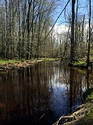 Cass River North Branch


See also edit
- Petroglyphs Provincial Park - largest collection of First Nations petroglyphs in Ontario, Canada
References edit
- ^ "Sanilac Petroglyphs in United States of America". protectedplanet.net. UN Environment Programme World Conservation Monitoring Centre. Retrieved April 30, 2020.
- ^ "Feature Detail Report for: Sanilac Petroglyphs Historic State Park". usgs.gov. Reston, Virginia: U.S. Geological Survey. May 5, 2009. GNIS ID#2554174. Retrieved May 4, 2020.
- ^ a b "When were Michigan state parks and recreation areas established?" (PDF). michigan.gov. Lansing, Michigan: Michigan Department of Natural Resources. Retrieved May 4, 2020.
- ^ a b c d Dietderich, Andrew (July 16, 2016). "Rock Of Ages: Sanilac Petroglyphs Unlike Any Other Michigan State Park". Tuscola County Advertiser. Caro, Michigan. Retrieved May 7, 2020.
- ^ a b c d e f "Saginaw Chippewa And State Of Michigan To Begin Co-management Of The Sanilac Petroglyphs Historic State Park". nativenewsonline.net. December 3, 2019. Retrieved May 4, 2020.
- ^ a b c d e Lavey, Kathleen (June 9, 2016). "Rare petroglyphs in Michigan provide link to Native American past". Detroit Free Press. Retrieved May 3, 2020.
- ^ a b "Rock of Ages: the Sanilac Petroglyphs". cranbrookartmuseum.org. Bloomfield Hills, Michigan: Cranbrook Art Museum. Retrieved May 4, 2020.
- ^ Fahlsing, Josh (April 22, 2003). "Historic petroglyphs park closed". Huron Daily Tribune. Bad Axe, Michigan. Retrieved May 4, 2020.
- ^ Billock, Jennifer (July 18, 2019). "Eight Spots in the United States Where You Can See Petroglyphs". smithsonianmag.com. Retrieved May 4, 2020.
- ^ "MDOT collaboration helps preserve Sanilac Petroglyphs". abc12.com. December 5, 2018. Retrieved May 4, 2020.
- ^ Battel, Brenda (October 13, 2018). "Thumb petroglyphs preserved with new technology". Huron Daily Tribune. Bad Axe, Michigan. Retrieved May 4, 2020.
- ^ "Vandals Deface The Sanilac Petroglyphs, A Michigan Sacred Site In Sanilac County". nativenewsonline.net. September 9, 2017. Retrieved May 4, 2020.
- ^ "Additional 140 acres of public hunting land now available in Sanilac County" (Press release). Lansing, Michigan: Michigan Department of Natural Resources. January 28, 2013. Retrieved May 13, 2020.
- ^ "Birding Sanilac County: Hotspots near Sandusky". birdingtrails.com. Retrieved May 13, 2020.
- ^ "Sanilac Petroglyphs". michigan.gov. Lansing, Michigan: Michigan History Center. Retrieved May 4, 2020.
- ^ "Sanilac Petroglyphs Visitor Information". Michigan History Center. State of Michigan. Retrieved December 17, 2022.
Further reading edit
- Curtis, Paul; Bennett, Kristen; Bugg, John; Johnson, Jeff; Popp, Anna (2012). General Management Plan: Sanilac Petroglyphs Historic State Park (PDF) (Report). Lansing, Michigan: Michigan Department of Natural Resources.
- Hatt, Robert T.; Richards, Darrel J.; Papworth, Mark (1958). The Sanilac petroglyphs. Bulletin 36. Bloomfield Hills, Michigan: Cranbrook Institute of Science.
External links edit
Sanilac Petroglyphs.
- 2018 Michigan Archaeology Awareness Poster: Ezhibiigaadek Asin: "Knowledge Written On Stone"
- "Sanilac Petroglyphs" on YouTube, Mike Wendland (June 1, 2008)
- The Teaching Rocks on Vimeo, Lloyd Walton (1987)