Saint-Casimir is a municipality of about 1800 people in the Portneuf Regional County Municipality in the province of Quebec, Canada. It is located on the Sainte-Anne River, about 80 kilometres (50 mi) southwest of Quebec City and 50 kilometres (31 mi) northeast of Trois-Rivières. It was founded in 1836 by people who came from Ste-Anne-de-la-Pérade following to the east along the Sainte-Anne.
Saint-Casimir | |
|---|---|
.jpg) Aerial view of Saint-Casimir | |
 Location within Portneuf RCM. | |
 Saint-Casimir Location in central Quebec. | |
| Coordinates: 46°39′N 72°08′W / 46.650°N 72.133°W[1] | |
| Country | |
| Province | |
| Region | Capitale-Nationale |
| RCM | Portneuf |
| Constituted | June 21, 2000 |
| Government | |
| • Mayor | Dominic Tessier Perry |
| • Federal riding | Portneuf—Jacques-Cartier |
| • Prov. riding | Portneuf |
| Area | |
| • Total | 68.10 km2 (26.29 sq mi) |
| • Land | 66.75 km2 (25.77 sq mi) |
| Elevation | 27.5 m (90.2 ft) |
| Population (2011)[3] | |
| • Total | 1,500 |
| • Density | 22.5/km2 (58/sq mi) |
| • Pop 2006-2011 | |
| • Dwellings | 736 |
| Time zone | UTC−5 (EST) |
| • Summer (DST) | UTC−4 (EDT) |
| Postal code(s) | |
| Area code(s) | 418 and 581 |
| Highways | |
| Website | www |
History edit
Saint-Casimir was founded in 1836 by people who came from Ste-Anne-de-la-Pérade following to the east along the Sainte-Anne. Alain Grandbois was born in Saint-Casimir in 1900.
In the summer of 1973, a wave on the Niagarette[4] devastated a small area, where it joins the Sainte-Anne River. A few houses were destroyed by the powerful water wave, due to strong rain, and debris that blocked the small river for a few hours.
On the morning of March 23, 1997, five members of the Order of the Solar Temple[5] took their own lives in Saint-Casimir. A small house exploded into flames, leaving behind five charred bodies for the police to pull from the rubble. Three teenagers—13, 14 and 16, the children of one of the couples that died in the fire —- are discovered in a shed behind the house, alive but heavily drugged.
Etymology edit
The name of Saint-Casimir was given in honour of Mr. Casimir Déry, a notary who paid for the construction of the church, which is in the top 10 of the most beautiful churches in the province of Québec. In turn, the church, and the town, is named after Saint Casimir, a patron saint of Poland, Lithuania, and youth.
Geography edit
Two provincial numbered roads go through St-Casimir: Route 354 (east-west - from Ste-Anne de la Pérade to St-Raymond) and Route 363 (south-north - from Deschambault to Lac-aux-Sables). Both roads lead to Autoroute 40, the Montreal-Québec City link on the north shore.
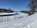
Five rivers run in Saint-Casimir: Sainte-Anne, Niagarette, Petite Niagarette, Blanche and Noire.
Saint-Casimir is also the home to a cavern, the "Trou du Diable" ("Devil's Hole"). It is the second-longest cave in Québec, at 980 metres (3,220 ft). It was formed by the former tributary of the Sainte-Anne River, which left behind a stream. Many tourists pass through it every summer.

Demographics edit
Population trend:[6]
- Population in 2011: 1500 (2006 to 2011 population change: -1.8%)
- Population in 2006: 1528
- Population in 2001: 1582
- Population total in 1996: 1783
- Saint-Casimir (municipality): 1347
- Saint-Casimir (parish): 436
- Population in 1991:
- Saint-Casimir (municipality): 1331
- Saint-Casimir (parish): 430
Private dwellings occupied by usual residents: 670 (total dwellings: 736)
Mother tongue:
- English as first language: 0%
- French as first language: 99%
- English and French as first language: 0%
- Other as first language: 1%
Photos edit
Saint-Casimir (Municipality)[7][8]
-
![Sacred Heart of Jesus Parish Cemetery and Church[9]](//upload.wikimedia.org/wikipedia/commons/thumb/a/a4/Saint_Casimir_058.jpg/120px-Saint_Casimir_058.jpg) Sacred Heart of Jesus Parish Cemetery and Church[9]
Sacred Heart of Jesus Parish Cemetery and Church[9] -
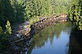
![Private residence, Sacré-Cœur-de-Jésus Parish Church, Sainte-Anne River, Bridge 06073, steel lower deck structure,[10][11] Roads 354 & 363](//upload.wikimedia.org/wikipedia/commons/thumb/b/b4/Saint_Casimir_007.jpg/120px-Saint_Casimir_007.jpg)
-
 Sainte-Anne River, Rang du Rapide Sud
 -

-
 Sainte-Anne River, sedimentary rocks, Trenton Group limestones, rock faces
 -
![Small tributary of the Sainte-Anne River at its exit from the cave of Trou du diable,[12] a few meters from its mouth](//upload.wikimedia.org/wikipedia/commons/thumb/3/35/Saint_Casimir_030.jpg/120px-Saint_Casimir_030.jpg) Small tributary of the Sainte-Anne River at its exit from the cave of Trou du diable,[12] a few meters from its mouth
Small tributary of the Sainte-Anne River at its exit from the cave of Trou du diable,[12] a few meters from its mouth -

-
 Agricultural zone, Roads 354 & 363 (Route des Grondines)
 -
![Rue Tessier (Quebec Road 354), bridge p 16132,[13] on Niagarette River](//upload.wikimedia.org/wikipedia/commons/thumb/e/e9/Saint_Casimir_031.jpg/120px-Saint_Casimir_031.jpg) Rue Tessier (Quebec Road 354), bridge p 16132,[13] on Niagarette River
Rue Tessier (Quebec Road 354), bridge p 16132,[13] on Niagarette River -
 Upstream entrance to the cave of the Devil's Hole
![Sacred Heart of Jesus Parish Cemetery and Church[9]](/wiki/File:Saint_Casimir_058.jpg)
![Private residence, Sacré-Cœur-de-Jésus Parish Church, Sainte-Anne River, Bridge 06073, steel lower deck structure,[10][11] Roads 354 & 363](/wiki/File:Saint_Casimir_007.jpg)


![Small tributary of the Sainte-Anne River at its exit from the cave of Trou du diable,[12] a few meters from its mouth](/wiki/File:Saint_Casimir_030.jpg)


![Rue Tessier (Quebec Road 354), bridge p 16132,[13] on Niagarette River](/wiki/File:Saint_Casimir_031.jpg)

See also edit
References edit
- ^ "Banque de noms de lieux du Québec: Reference number 55781". toponymie.gouv.qc.ca (in French). Commission de toponymie du Québec.
- ^ Ministère des Affaires municipales, des Régions et de l'Occupation du territoire - Répertoire des municipalités: Saint-Casimir
- ^ a b "Saint-Casimir, Quebec (Code 2434078) Census Profile". 2011 census. Government of Canada - Statistics Canada.
- ^ Genois, Gaétan. "Page of history: the flood in Saint-Casimir, August 10, 1973". Le Courrier de Portneuf (in Canadian French). Retrieved 13 September 2023.
- ^ "La fin tragique de la secte de l'Ordre du Temple solaire" [The tragic end of the cult of the Order of the Solar Temple]. Aujourd'hui l'histoire (in Canadian French). Ici Radio-Canada Première. Retrieved 13 September 2023.
- ^ Statistics Canada: 1996, 2001, 2006, 2011 census
- ^ Paul Hinse. "Inventory of Portneuvois' built heritage - Saint-Casimir - John William Hopkins" (PDF) (in French). pp. 65 on 248. Retrieved 30 October 2023.
- ^ "Saint-Casimir, odonymie" (PDF) (in French). Saint-Casimir. 2019. p. 5. Retrieved 31 October 2023.
- ^ "Virtual tour, church of St_Casimir" (in French). Portneuf virtual. Retrieved 30 October 2023.
- ^ "Inventory and inspection of structures". Quebec Gouvernement. Ministry of Transport and Sustainable Mobility. Retrieved 27 May 2023.
- ^ "Fermeture préventive du pont de la route 354 à Saint-Casimir" (in French). Courrier de Portneuf. 26 April 2023. Retrieved 2 September 2023.
- ^ "Grotte le Trou du Diable". Parc naturel régional de Portneuf (in French). Société québécoise de spéléologie. Retrieved 6 September 2023.
- ^ "Inventory and inspection of structures". Quebec Gouvernement. Ministry of Transport and Sustainable Mobility. Retrieved 27 May 2023.
External links edit
- St. Casimir's Family and Seniors Policy, Collection BAnQ, September 9, 2013 (in French)
- Station Météo St-Casimir (in French and English)
- Photos Saint-Casimir St-Casimir Photo Gallery (in French)
- Cultural Rendez-vous of St-Casimir (french) (in French)
- Auberge du Couvent (french) (in French)
- Trou du Diable (Devil's Hole) (in French)