Sagogn (Romansh pronunciation: [sɐˈɡɔɲ] ⓘ; German: Sagens) is a municipality in the Surselva Region in the canton of Graubünden in Switzerland.
Sagogn | |
|---|---|
 | |
 Coat of arms | |
Location of Sagogn  | |
 Sagogn  Sagogn | |
| Coordinates: 46°47′N 9°15′E / 46.783°N 9.250°E | |
| Country | Switzerland |
| Canton | Graubünden |
| District | Surselva |
| Area | |
| • Total | 6.92 km2 (2.67 sq mi) |
| Elevation | 779 m (2,556 ft) |
| Population (31 December 2018)[2] | |
| • Total | 719 |
| • Density | 100/km2 (270/sq mi) |
| Time zone | UTC+01:00 (Central European Time) |
| • Summer (DST) | UTC+02:00 (Central European Summer Time) |
| Postal code(s) | 7152 |
| SFOS number | 3581 |
| ISO 3166 code | CH-GR |
| Surrounded by | Castrisch, Falera, Flims, Laax, Schluein, Valendas, Versam |
| Website | www SFSO statistics |
History edit
Sagogn is first mentioned in 765 as Secanio.[3]
Geography edit


Sagogn has an area, as of 2006[update], of 7 km2 (2.7 sq mi). Of this area, 23.2% is used for agricultural purposes, while 59.7% is forested. Of the rest of the land, 4.7% is settled (buildings or roads) and the remainder (12.4%) is non-productive (rivers, glaciers or mountains).[4]
Before 2017, the municipality was located in the Ilanz sub-district of the Surselva district, after 2017 it was part of the Surselva Region.[5] It is on the northern slope above the Vorderrhein on the bank of the Gruob (or Foppa). It consists of the village sections of Innerdorf (Vitg Dadens) and Ausserdorf (Vitg Dado). Until 1943 Sagogn was known by its German name as Sagens.[6]
Demographics edit
Sagogn has a population (as of 31 December 2020) of 736.[7] As of 2008[update], 6.6% of the population was made up of foreign nationals.[8] Over the last 10 years the population has decreased at a rate of -5.4%. Most of the population (as of 2000[update]) speaks Romansh (57.1%), with German being second most common (41.4%) and Dutch being third ( 0.3%).[4] The official language is the Sursilvan dialect of Romansh.
As of 2000[update], the gender distribution of the population was 55.0% male and 45.0% female.[9] The age distribution, as of 2000[update], in Sagogn is; 60 children or 10.1% of the population are between 0 and 9 years old and 93 teenagers or 15.6% are between 10 and 19. Of the adult population, 63 people or 10.6% of the population are between 20 and 29 years old. 92 people or 15.4% are between 30 and 39, 95 people or 15.9% are between 40 and 49, and 79 people or 13.2% are between 50 and 59. The senior population distribution is 60 people or 10.1% of the population are between 60 and 69 years old, 26 people or 4.4% are between 70 and 79, there are 23 people or 3.9% who are between 80 and 89 there are 6 people or 1.0% who are between 90 and 99.[8]
In the 2007 federal election the most popular party was the SVP which received 32.6% of the vote. The next three most popular parties were the CVP (29.8%), the SP (23.4%) and the FDP (12.2%).[4]
In Sagogn about 74.9% of the population (between age 25 and 64) have completed either non-mandatory upper secondary education or additional higher education (either university or a Fachhochschule).[4]
Sagogn has an unemployment rate of 0.98%. As of 2005[update], there were 13 people employed in the primary economic sector and about 5 businesses involved in this sector. 22 people are employed in the secondary sector and there are 8 businesses in this sector. 33 people are employed in the tertiary sector, with 11 businesses in this sector.[4]
The historical population is given in the following table:[3][9]
| year | population |
|---|---|
| 1803 | 399 |
| 1850 | 535 |
| 1900 | 405 |
| 1950 | 492 |
| 1970 | 383 |
| 1990 | 611 |
| 2000 | 597 |
Heritage sites of national significance edit
The Church of S. Maria, and the prehistoric settlement, medieval castle and church at Schiedberg Castle/Bregl da Haida are listed as Swiss heritage sites of national significance.[10]
The Church of S. Maria was built in 1634, while the church tower is from an earlier structure and was built in 1449. The church has a three-bay nave with a rectangular choir and transept and two side chapels. The ceiling and wall murals were painted in 1639 by Giov. Batt. Macholino. The high and side altars date from about the same time. The castle site at Scheidberg has been occupied since the prehistoric era. The castle served to protect the Lukmanier Pass trade route.[11] The church at nearby Bregl da Haida was built in the 5th century and replaced with a Carolingian church in the 7th century. The church had a single nave and a horseshoe shaped apse. It was mentioned in the Testament of Bischof Tello in 765 as the Columbans church. This church may have been a private chapel for the raetian Viktoriden family, who lived in a nearby manor house.
-
 Church of S. Maria
 -
 Floorplan of the ruins of Burg Schiedberg
 -
 Burg Schiedberg hill
 -
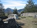 Castle Schiedberg ruins, looking north
 -
 Location of Bregl da Haida
 -
 Bregl da Haida floorplan and growth
 -
 Bregl da Haida foundations


Transport edit
Valendas-Sagogn station, on the line of the Rhaetian Railway that links Chur and Disentis, lies some 120 metres (390 ft) below and 2.3 kilometres (1.4 mi) distant from the village of Sagogn.[12]
References edit
- ^ a b "Arealstatistik Standard - Gemeinden nach 4 Hauptbereichen". Federal Statistical Office. Retrieved 13 January 2019.
- ^ "Ständige Wohnbevölkerung nach Staatsangehörigkeitskategorie Geschlecht und Gemeinde; Provisorische Jahresergebnisse; 2018". Federal Statistical Office. 9 April 2019. Retrieved 11 April 2019.
- ^ a b Sagogn in German, French and Italian in the online Historical Dictionary of Switzerland.
- ^ a b c d e Swiss Federal Statistical Office accessed 13-Nov-2009
- ^ Swiss Federal Statistical Office - Amtliches Gemeindeverzeichnis der Schweiz - Mutationsmeldungen 2016 accessed 16 February 2017
- ^ Amtliches Gemeindeverzeichnis der Schweiz published by the Swiss Federal Statistical Office (in German) accessed 23 September 2009
- ^ "Ständige und nichtständige Wohnbevölkerung nach institutionellen Gliederungen, Geburtsort und Staatsangehörigkeit". bfs.admin.ch (in German). Swiss Federal Statistical Office - STAT-TAB. 31 December 2020. Retrieved 21 September 2021.
- ^ a b Graubunden Population Statistics Archived 2009-08-27 at the Wayback Machine (in German) accessed 21 September 2009
- ^ a b Graubunden in Numbers Archived 2009-09-24 at the Wayback Machine (in German) accessed 21 September 2009
- ^ Swiss inventory of cultural property of national and regional significance Archived 2009-05-01 at the Wayback Machine 21.11.2008 version, (in German) accessed 13-Nov-2009
- ^ Flüeler (1982). Kulturführer Schweiz. Zurich, CH: Ex Libris Verlag AG. pp. 324–325.
- ^ "1194 - Flims" (Map). Valendas-Sagogn railway station (2016 ed.). 1:25 000. National Map 1:25'000. Federal Office of Topography - swisstopo. 2014. ISBN 978-3-302-01194-3. Retrieved 2017-06-05 – via map.geo.admin.ch.
External links edit
- Official website (in Romansh and German)
- Sagogn in German, French and Italian in the online Historical Dictionary of Switzerland.