Rajasansi is a town, near Amritsar city and a nagar panchayat in Amritsar district in the Indian state of Punjab. Sri Guru Ram Dass Jee International Airport (Amritsar International Airport) is located in Rajasansi village on Ajnala-Rajasansi Road. Raja Sansi Assembly Constituency is also an assembly segment in the Punjab Legislative Assembly, which is currently represented by Sukhbinder Singh Sarkaria.
Rajasansi | |
|---|---|
 Amritsar International Airport in Rajasansi, Amritsar (Punjab) | |
 Rajasansi Location in Punjab, India  Rajasansi Rajasansi (India) | |
| Coordinates: 31°43′28″N 74°47′10″E / 31.7245°N 74.786°E | |
| Country | |
| State | Punjab |
| District | Amritsar |
| Population (2001) | |
| • Total | 12,131 |
| Languages | |
| • Official | Punjabi |
| Time zone | UTC+5:30 (IST) |
Demographics edit
As of 2001[update] India census,[2] Rajasansi had a population of 12,131. Males constitute 54% of the population and females 46%. In Rajasansi, 13% of the population is under 6 years of age.
The table below shows the population of different religious groups in Raja Sansi city and their gender ratio, as of 2011 census.
| Religion | Total | Female | Male | Gender ratio |
|---|---|---|---|---|
| Sikh | 10,175 | 4,754 | 5,421 | 876 |
| Hindu | 2,866 | 1,305 | 1,561 | 836 |
| Christian | 1,143 | 589 | 554 | 1063 |
| Muslim | 87 | 35 | 52 | 673 |
| Buddhist | 4 | 1 | 3 | 333 |
| Jain | 4 | 2 | 2 | 1000 |
| Not stated | 19 | 9 | 10 | 900 |
| Total | 14,298 | 6,695 | 7,603 | 880 |
Climate edit
Rajasansi has a semiarid climate, typical of Northwestern India and experiences four seasons primarily: winter season (December to March, when temperatures can drop to −1 °C (30 °F), summer season (April to June) where temperatures can reach 45 °C (113 °F), monsoon season (July to September) and post-monsoon season (October to November). Annual rainfall is about 703.4 millimetres (27.7 in).[4] The lowest recorded temperature is −3.6 °C (25.5 °F), was recorded on 9 December 1996 and the highest temperature, 47.8 °C (118.0 °F), was recorded on 9 June 1995.[5] The official weather station for the village is the Civil Aerodrome. Weather records here date back to 15 November 1947.
| Climate data for Rajasansi(1981-2010 normals, extremes 1947-present; humidity and sunshine 1961-1990) | |||||||||||||
|---|---|---|---|---|---|---|---|---|---|---|---|---|---|
| Month | Jan | Feb | Mar | Apr | May | Jun | Jul | Aug | Sep | Oct | Nov | Dec | Year |
| Record high °C (°F) | 26.8 (80.2) |
32.2 (90.0) |
36.2 (97.2) |
44.1 (111.4) |
47.7 (117.9) |
47.8 (118.0) |
45.6 (114.1) |
40.7 (105.3) |
40.6 (105.1) |
38.3 (100.9) |
34.2 (93.6) |
28.5 (83.3) |
47.8 (118.0) |
| Mean maximum °C (°F) | 23 (73) |
26.1 (79.0) |
32 (90) |
40.5 (104.9) |
44 (111) |
44.1 (111.4) |
39.8 (103.6) |
37.1 (98.8) |
36.8 (98.2) |
35.5 (95.9) |
30.5 (86.9) |
24.9 (76.8) |
45.2 (113.4) |
| Mean daily maximum °C (°F) | 18.4 (65.1) |
21.7 (71.1) |
26.8 (80.2) |
34.2 (93.6) |
39 (102) |
39 (102) |
35 (95) |
34.2 (93.6) |
34.1 (93.4) |
32 (90) |
27.1 (80.8) |
21.1 (70.0) |
30.2 (86.4) |
| Mean daily minimum °C (°F) | 3.4 (38.1) |
6.3 (43.3) |
10.9 (51.6) |
16.1 (61.0) |
21.3 (70.3) |
24.3 (75.7) |
25.3 (77.5) |
24.9 (76.8) |
22.1 (71.8) |
15.4 (59.7) |
8.7 (47.7) |
4.1 (39.4) |
15.2 (59.4) |
| Mean minimum °C (°F) | −0.5 (31.1) |
1.7 (35.1) |
5.6 (42.1) |
10.2 (50.4) |
15.8 (60.4) |
19.6 (67.3) |
21.7 (71.1) |
21.4 (70.5) |
17.8 (64.0) |
10.7 (51.3) |
4.2 (39.6) |
0.1 (32.2) |
−1.2 (29.8) |
| Record low °C (°F) | −2.9 (26.8) |
−2.6 (27.3) |
2 (36) |
6.4 (43.5) |
9.6 (49.3) |
15.6 (60.1) |
18.2 (64.8) |
18.8 (65.8) |
13 (55) |
7.3 (45.1) |
−0.6 (30.9) |
−3.6 (25.5) |
−3.6 (25.5) |
| Average rainfall mm (inches) | 26.2 (1.03) |
38.6 (1.52) |
38.4 (1.51) |
21.4 (0.84) |
26.7 (1.05) |
61.2 (2.41) |
210.1 (8.27) |
167.3 (6.59) |
77.5 (3.05) |
16.1 (0.63) |
6.3 (0.25) |
13.6 (0.54) |
703.4 (27.69) |
| Average rainy days (≥ 1.0 mm) | 2.1 | 3.3 | 3.2 | 2 | 2.4 | 3.8 | 8.6 | 6.9 | 3.5 | 1.1 | 0.6 | 1.4 | 38.9 |
| Average relative humidity (%) | 74 | 70 | 64 | 47 | 38 | 48 | 72 | 77 | 69 | 67 | 73 | 76 | 65 |
| Mean monthly sunshine hours | 181.7 | 192.7 | 219.4 | 265.0 | 294.7 | 269.0 | 215.5 | 227.7 | 240.8 | 253.2 | 220.1 | 182.2 | 2,762 |
| Source: [6][7] | |||||||||||||
Politics edit
The city is part of the Raja Sansi Assembly Constituency.
Gallery edit
-
 Rajasansi International Airport
 -
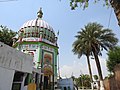 Dargah Baba Hussain Shah Kadri


See also edit
References edit
- ^ "Raja Sansi Nagar Panchayat City Population Census 2011-2022 | Punjab".
- ^ "Census of India 2001: Data from the 2001 Census, including cities, villages and towns (Provisional)". Census Commission of India. Archived from the original on 16 June 2004. Retrieved 1 November 2008.
- ^ https://censusindia.gov.in/nada/index.php/catalog/11389, India - C-01: Population by religious community, Punjab - 2011, Raja Sansi (NP)
- ^ "Amritsar Climate Normals 1981-2010" (PDF). Indian Meteorological Department, Pune. Retrieved 31 March 2020.
- ^ "Amritsar Climate Normals 1981-2010" (PDF). Indian Meteorological Department, Pune. Retrieved 31 March 2020.
- ^ "Amritsar Climate Normals 1981-2010" (PDF). Indian Meteorological Department, Pune. Retrieved 31 March 2020.
- ^ "Amritsar Climate Normals 1971–1990". National Oceanic and Atmospheric Administration. Retrieved 11 January 2014.
This article about a location in the Indian state of Punjab is a stub. You can help Wikipedia by expanding it. |