Route 201 is a north/south provincial highway within the Canadian province of Quebec, running between Route 202 in Franklin (near the Canada–US border) and Route 342 in Rigaud. Its total length is approximately 70 kilometres.
Route 201 | ||||
|---|---|---|---|---|
 | ||||
| Route information | ||||
| Maintained by Transports Québec | ||||
| Length | 69.8 km[1] (43.4 mi) | |||
| Major junctions | ||||
| South end | ||||
| North end | ||||
| Location | ||||
| Country | Canada | |||
| Province | Quebec | |||
| Highway system | ||||
| ||||

Route 201 links Salaberry-de-Valleyfield with Autoroute 20 using the Monseigneur Langlois Bridge to cross the Saint Lawrence River. It is among the five primary or secondary highways to cross the Saint Lawrence River and is the only 200 series highway to be partly north of that river.
Municipalities along Route 201 edit

- Franklin
- Ormstown
- Saint-Stanislas-de-Kostka
- Salaberry-de-Valleyfield
- Coteau-du-Lac
- Saint-Clet
- Saint-Lazare
- Sainte-Marthe
- Rigaud
-
 Southern end at route 202.
 -
 Intersection with Route 132 in Saint-Stanislas.
 -
 Route 201 is concurrent with Route 132 and Autoroute 530.
 -
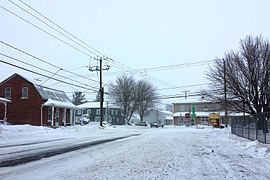
 Route 201 in Valleyfield.
 -
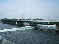 Monseigneur-Langlois Bridge between Valleyfield and Coteau-du-Lac.
 -
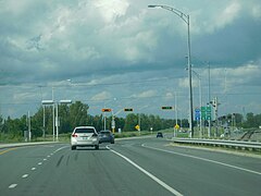
 Interchange with Autoroute 20.
 -
 Junction of 340 and 201 in Saint-Clet.
.jpg)
.jpg)
.jpg)

.jpg)

Major intersections edit
| RCM | Location | km[2] | mi | Destinations | Notes | |
|---|---|---|---|---|---|---|
| Le Haut-Saint-Laurent | Franklin | 0.0 | 0.0 | R-201 southern terminus | ||
| 2.4 | 1.5 | |||||
| Saint-Chrysostome | 13.6 | 8.5 | South end of R-138 concurrency | |||
| 14.8 | 9.2 | North end of R-138 concurrency | ||||
| Beauharnois-Salaberry | Saint-Stanislas-de-Kostka – Saint-Louis-de-Gonzague boundary | 23.8 | 14.8 | |||
| Saint-Stanislas-de-Kostka | 29.6 | 18.4 | South end of R-132 concurrency | |||
| Canal de Beauharnois | 30.3– 31.3 | 18.8– 19.4 | Pont Larocque (Larocque Bridge) | |||
| Beauharnois-Salaberry | Salaberry-de-Valleyfield | 31.6 | 19.6 | At grade; A-530 western terminus; west end of A-530 concurrency | ||
| 36.5 | 22.7 | A-530 exit 5; east end of A-530 concurrency | ||||
| 37.5 | 23.3 | North end of R-132 concurrency | ||||
| St. Lawrence River | 43.3– 45.4 | 26.9– 28.2 | Pont Monseigneur-Langlois (Monseigneur Langlois Bridge) | |||
| Vaudreuil-Soulanges | Coteau-du-Lac | 45.4 | 28.2 | Chemin du Fleuve | Interchange; northbound exit and southbound entrance | |
| 46.0 | 28.6 | Interchange | ||||
| 46.9 | 29.1 | Interchange; A-20 exit 14; south end of A-20 concurrency | ||||
| 49.6 | 30.8 | Interchange; A-20 exit 17; north end of A-20 concurrency | ||||
| Saint-Clet | 56.7 | 35.2 | ||||
| Rigaud | 69.4 | 43.1 | Interchange; A-40 exit 17 | |||
| 69.8 | 43.4 | R-201 northern terminus | ||||
1.000 mi = 1.609 km; 1.000 km = 0.621 mi
| ||||||
See also edit
References edit
- ^ Ministère des transports, "Distances routières", page 79, Les Publications du Québec, 2005
- ^ Google (April 14, 2023). "Route 201 in Quebec" (Map). Google Maps. Google. Retrieved April 14, 2023.
External links edit
- Route 201 on Google Maps
- Official Transport Quebec Road Map (Courtesy of the Quebec Ministry of Transportation) (in French)