Penzhinsky District (Russian: Пе́нжинский райо́н) is an administrative[1] and municipal[5] district (raion) of Koryak Okrug in Kamchatka Krai, Russia, one of the eleven in the krai. It is located in the northwest of the krai. Its administrative center is the rural locality (a selo) of Kamenskoye.[1] Population: 2,340 (2010 Russian census);[3] 2,990 (2002 Census);[7] 5,301 (1989 Soviet census).[8] The population of Kamenskoye accounts for 28.0% of the district's total population.[3]
Penzhinsky District
Пенжинский район | |
|---|---|
 Coast in Penzhinsky District | |
.png) Flag .png) Coat of arms | |
 Location of Penzhinsky District in Koryak Okrug, Kamchatka Krai | |
| Coordinates: 63°N 167°E / 63°N 167°E | |
| Country | Russia |
| Federal subject | Kamchatka Krai[1] |
| Established | 1 April 1926 |
| Administrative center | Kamenskoye[1] |
| Area | |
| • Total | 116,086 km2 (44,821 sq mi) |
| Population | |
| • Total | 2,340 |
| • Estimate (2018)[4] | 2,099 (−10.3%) |
| • Density | 0.020/km2 (0.052/sq mi) |
| • Urban | 0% |
| • Rural | 100% |
| Administrative structure | |
| • Inhabited localities[1] | 7 rural localities |
| Municipal structure | |
| • Municipally incorporated as | Penzhinsky District[5] |
| • Municipal divisions[5] | 0 urban settlements, 5 rural settlements |
| Time zone | UTC+12 (MSK+9 |
| OKTMO ID | 30829000 |
| Website | http://xn----8sbnekahce1acgmcyl.xn--p1ai/ |
Ethnic composition (2021):[9]
- Koryaks – 44.8%
- Russians – 29.8%
- Evens – 12%
- Chukchi – 6.1%
- Ukrainians – 1.4%
- Others – 5.9%
Geography edit
The area of the district is 116,086 square kilometers (44,821 sq mi).[2]
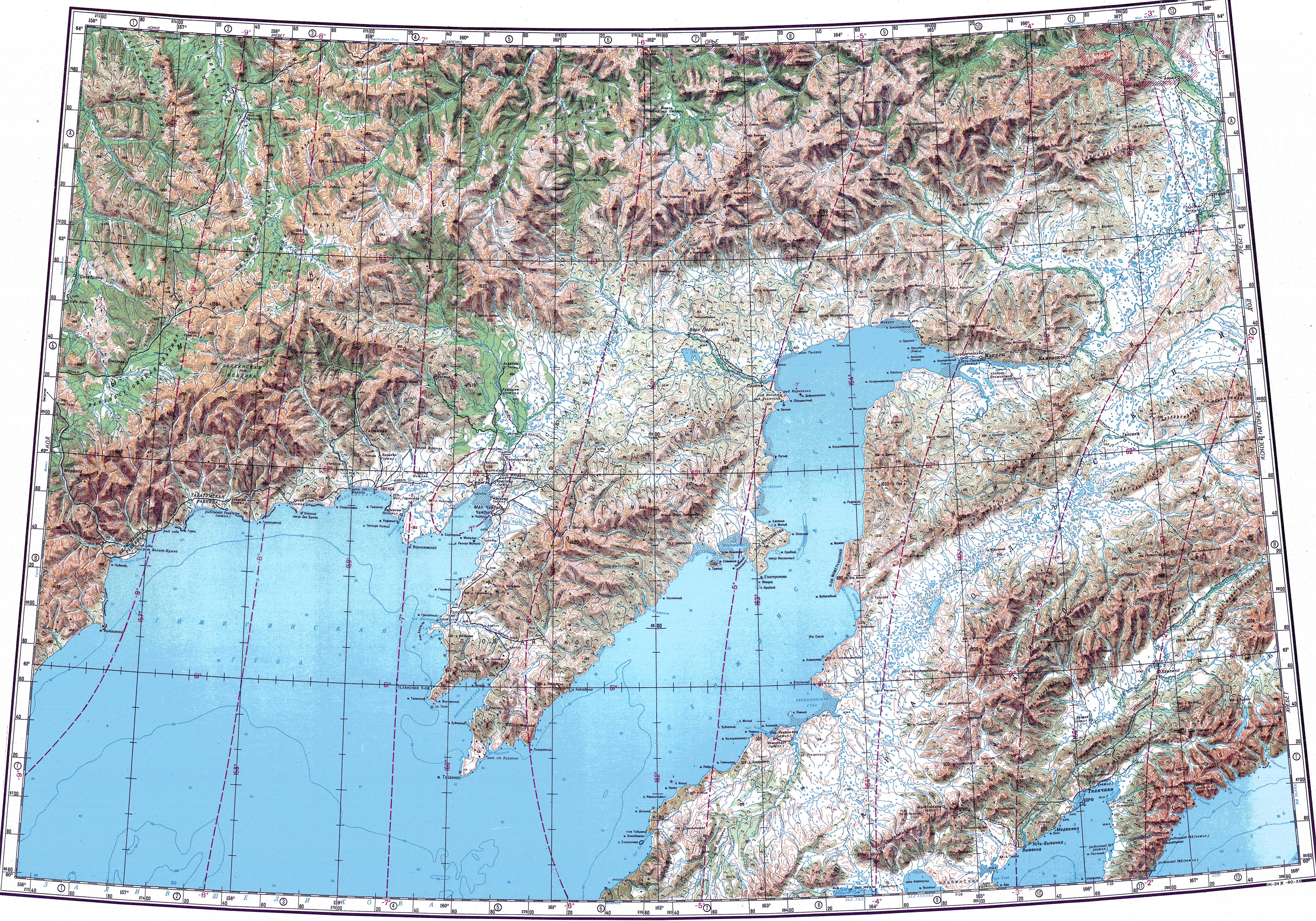
The Ichigem Range, the northwesternmost range of the Koryak Highlands, rises in the district. Rivers Penzhina, Belaya, Oklan, Esgichninvayam and Zhirovaya are the main rivers flowing through the territory of the district.[10]
References edit
Notes edit
- ^ a b c d e Law #46
- ^ a b "General Information" (in Russian). Penzhinsky District. Retrieved August 31, 2016.
- ^ a b c Russian Federal State Statistics Service (2011). Всероссийская перепись населения 2010 года. Том 1 [2010 All-Russian Population Census, vol. 1]. Всероссийская перепись населения 2010 года [2010 All-Russia Population Census] (in Russian). Federal State Statistics Service.
- ^ "26. Численность постоянного населения Российской Федерации по муниципальным образованиям на 1 января 2018 года". Federal State Statistics Service. Retrieved January 23, 2019.
- ^ a b c Law #337-oz
- ^ "Об исчислении времени". Официальный интернет-портал правовой информации (in Russian). June 3, 2011. Retrieved January 19, 2019.
- ^ Federal State Statistics Service (May 21, 2004). Численность населения России, субъектов Российской Федерации в составе федеральных округов, районов, городских поселений, сельских населённых пунктов – районных центров и сельских населённых пунктов с населением 3 тысячи и более человек [Population of Russia, Its Federal Districts, Federal Subjects, Districts, Urban Localities, Rural Localities—Administrative Centers, and Rural Localities with Population of Over 3,000] (XLS). Всероссийская перепись населения 2002 года [All-Russia Population Census of 2002] (in Russian).
- ^ Всесоюзная перепись населения 1989 г. Численность наличного населения союзных и автономных республик, автономных областей и округов, краёв, областей, районов, городских поселений и сёл-райцентров [All Union Population Census of 1989: Present Population of Union and Autonomous Republics, Autonomous Oblasts and Okrugs, Krais, Oblasts, Districts, Urban Settlements, and Villages Serving as District Administrative Centers]. Всесоюзная перепись населения 1989 года [All-Union Population Census of 1989] (in Russian). Институт демографии Национального исследовательского университета: Высшая школа экономики [Institute of Demography at the National Research University: Higher School of Economics]. 1989 – via Demoscope Weekly.
- ^ "Национальный состав населения". Federal State Statistics Service. Retrieved March 26, 2023.
- ^ "Топографска карта P-57_58 - Topographic USSR Chart (in Russian)". Retrieved February 22, 2022.
Sources edit
- Законодательное Собрание Камчатского края. Закон №46 от 29 апреля 2008 г. «Об административно-территориальном устройстве Камчатского края», в ред. Закона №659 от 30 июля 2015 г. «О внесении изменения в статью 5 Закона Камчатского края "Об административно-территориальном устройстве Камчатского края"». Вступил в силу со дня официального опубликования. Опубликован: "Официальные Ведомости", №65-69, 6 мая 2008 г. (Legislative Assembly of Kamchatka Krai. Law #46 of April 29, 2008 On the Administrative-Territorial Structure of Kamchatka Krai, as amended by the Law #659 of July 30, 2015 On Amending Article 5 of the Law of Kamchatka Krai "On the Administrative-Territorial Structure of Kamchatka Krai". Effective as of the day of the official publication.).
- Дума Корякского автономного округа. Закон №337-оз от 9 ноября 2004 г. «О территории и границах муниципального образования "Пенжинский муниципальный район"», в ред. Закона №222 от 29 декабря 2008 г. «О внесении изменения в статью 1 Закона Корякского автономного округа "О территории и границах муниципального образования "Пенжинский муниципальный район"». Вступил в силу через 10 дней после официального опубликования. Опубликован: "Народовластие", №95, 24 ноября 2004 г. (Duma of Koryak Autonomous Okrug. Law #337-oz of November 9, 2004 On the Territory and the Borders of the Municipal Formation of "Penzhinsky Municipal District", as amended by the Law #222 of December 29, 2008 On Amending Article 1 of the Law of Koryak Autonomous Okrug "On the Territory and the Borders of the Municipal Formation of "Penzhinsky Municipal District"". Effective as of the day which is ten days after the official publication.).