Parson's Pond is a community in the province of Newfoundland and Labrador in Canada.
Parson's Pond
Sandy Bay | |
|---|---|
Town | |
 Parson's Pond Location of Parson's Pond in Newfoundland | |
| Coordinates: 50°02′13″N 57°41′49″W / 50.03694°N 57.69694°W | |
| Country | |
| Province | |
| Population (2021)[1] | |
| • Total | 368 |
| Time zone | UTC-3:30 (Newfoundland Time) |
| • Summer (DST) | UTC-2:30 (Newfoundland Daylight) |
| Area code | 709 |
| Highways | |
History edit
Parson's Pond was originally called Sandy Bay. It is located on the Great Northern Peninsula. The first census was in the late 19th century and had a population of just 18, by 2001 the population was 427.
Demographics edit
In the 2021 Census of Population conducted by Statistics Canada, Parson's Pond had a population of 368 living in 177 of its 216 total private dwellings, a change of 6.7% from its 2016 population of 345. With a land area of 12.34 km2 (4.76 sq mi), it had a population density of 29.8/km2 (77.2/sq mi) in 2021.[1]
Tourism edit
Parson's Pond, which has a small harbour, is on route 430 which is known as the Viking Trail. From the town there is a scenic view to Gros Morne National Park which is just 5 km to the south. The Arches Provincial Park with an interesting geological formation of limestone formed by glacial action, wind and water erosion is 10 km north of the town.[2]
Parson's Pond is also known as the final resting place of Zachary Turner after being involved with a murder-suicide with his mother, Shirley Jane Turner.[3]
-
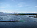 View to Gros Morne National Park
 -
 Harbour
 -
 General view of Parson's Pond


References edit
- ^ a b "Population and dwelling counts: Canada, provinces and territories, census divisions and census subdivisions (municipalities), Newfoundland and Labrador". Statistics Canada. February 9, 2022. Retrieved March 15, 2022.
- ^ Andrew Hampstead: Atlantic Canada, p.377, Berkeley CA 2012
- ^ Fegan, Matt (Oct 14, 2004). "Murder-suicide funeral: An assignment to dread". King's Journalism Review. Vol. 10. Archived from the original on January 19, 2016. Retrieved March 3, 2014.