Pagudpud, officially the Municipality of Pagudpud (Ilocano: Ili ti Pagudpud; Filipino: Bayan ng Pagudpud), is a 4th class municipality in the province of Ilocos Norte, Philippines. According to the 2020 census, it has a population of 25,098 people.[3]
Pagudpud | |
|---|---|
| Municipality of Pagudpud | |
 From top to bottom right: Welcome arch passing through Pan-Philippine Highway, Dos Hermanos islands, Bantay Abot cave, Patapat Viaduct overlooking Pasaleng Bay, and Blue Lagoon | |
 Flag  Seal | |
 Map of Ilocos Norte with Pagudpud highlighted | |
OpenStreetMap  | |
.svg) Pagudpud Location within the Philippines | |
| Coordinates: 18°33′41″N 120°47′16″E / 18.5614°N 120.7878°E | |
| Country | Philippines |
| Region | Ilocos Region |
| Province | Ilocos Norte |
| District | 1st district |
| Founded | February 14, 1954 |
| Barangays | 16 (see Barangays) |
| Government | |
| • Type | Sangguniang Bayan |
| • Mayor | Rafael Ralph L. Benemerito II |
| • Vice Mayor | Bingbong Calvan |
| • Representative | Ferdinand Alexander Araneta Marcos III |
| • Municipal Council | Members |
| • Electorate | 18,452 voters (2022) |
| Area | |
| • Total | 194.90 km2 (75.25 sq mi) |
| Elevation | 92 m (302 ft) |
| Highest elevation | 1,295 m (4,249 ft) |
| Lowest elevation | 0 m (0 ft) |
| Population (2020 census)[3] | |
| • Total | 25,098 |
| • Density | 130/km2 (330/sq mi) |
| • Households | 6,690 |
| Economy | |
| • Income class | 4th municipal income class |
| • Poverty incidence | 8.21 |
| • Revenue | ₱ 182 million (2020) |
| • Assets | ₱ 569.7 million (2020) |
| • Expenditure | ₱ 220 million (2020) |
| • Liabilities | ₱ 277.3 million (2020) |
| Service provider | |
| • Electricity | Ilocos Norte Electric Cooperative (INEC) |
| Time zone | UTC+8 (PST) |
| ZIP code | 2919 |
| PSGC | |
| IDD : area code | +63 (0)77 |
| Native languages | Ilocano Tagalog |
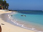
It is the northernmost settlement on Luzon Island and a popular tourist destination because of its resorts and beaches. In addition to tourism, people also make their living through farming, fishing and subsistence retailing. Recently, many windmills are erected in Barangay Caparispisan.
History edit
Pagudpud was made a municipality on 14 February 1954[5] through the leadership of Constante Benemerito. It was Rafael "Totoy" Benemerito, son of Constante, who spearheaded the establishment of the first municipal hall, municipal health center, public plaza, and public market. It had previously been a part of the neighboring town of Bangui.
Geography edit
Pagudpud lies 74 kilometres (46 mi) north of Laoag City, the provincial capital, and 561 kilometres (349 mi) north of Manila. Maira-ira Beach is the northernmost tip of Luzon Island, located at 18°33′34″N 120°47′15″E / 18.55944°N 120.78750°E on the Luzon Strait.
The town's topography includes mountains, hills, valleys and flat coastal land.
Barangays edit
Pagudpud is politically divided into 16 barangays. Each barangay consists of puroks and some have sitios.
There are 2 barangays that are considered urban (highlighted in bold) and 3 barangays that are considered the eastern part (highlited in italic.
- Aggasi
- Baduang
- Balaoi
- Burayoc
- Caparispisan
- Caunayan
- Dampig
- Ligaya
- Pancian
- Pasaleng
- Poblacion 1
- Poblacion 2
- Saguigui
- Saud
- Subec
- Tarrag
Climate edit
| Climate data for Pagudpud, Ilocos Norte | |||||||||||||
|---|---|---|---|---|---|---|---|---|---|---|---|---|---|
| Month | Jan | Feb | Mar | Apr | May | Jun | Jul | Aug | Sep | Oct | Nov | Dec | Year |
| Mean daily maximum °C (°F) | 31 (88) |
32 (90) |
33 (91) |
34 (93) |
34 (93) |
34 (93) |
33 (91) |
32 (90) |
32 (90) |
33 (91) |
32 (90) |
31 (88) |
33 (91) |
| Mean daily minimum °C (°F) | 19 (66) |
20 (68) |
21 (70) |
23 (73) |
24 (75) |
24 (75) |
24 (75) |
24 (75) |
24 (75) |
23 (73) |
22 (72) |
21 (70) |
22 (72) |
| Average rainfall mm (inches) | 6.2 (0.24) |
11.7 (0.46) |
10.1 (0.40) |
14 (0.6) |
192.7 (7.59) |
258.9 (10.19) |
470.9 (18.54) |
475.9 (18.74) |
405.7 (15.97) |
92.5 (3.64) |
44.8 (1.76) |
2 (0.1) |
1,985.4 (78.23) |
| Average rainy days | 3 | 2 | 2 | 2 | 12 | 15 | 20 | 20 | 17 | 10 | 6 | 3 | 112 |
| Source: World Weather Online[6] | |||||||||||||
Demographics edit
|
| |||||||||||||||||||||||||||||||||||||||
| Source: Philippine Statistics Authority[7][8][9][10] | ||||||||||||||||||||||||||||||||||||||||
In the 2020 census, the population of Pagudpud was 25,098 people,[3] with a density of 130 inhabitants per square kilometre or 340 inhabitants per square mile.
Religion edit
Roman Catholicism is the major religion in Pagudpud. Yet, there's also increasing numbers of members of other Christian Denominations such as Jehovah's Witnesses (with two congregations) and Iglesia ni Cristo. Islam, brought by Muslim immigrants, is also practiced in Pagudpud.
Economy edit
Graphs are unavailable due to technical issues. There is more info on Phabricator and on MediaWiki.org. |
Government edit
Local government edit
Pagudpud, belonging to the first congressional district of the province of Ilocos Norte, is governed by a mayor designated as its local chief executive and by a municipal council as its legislative body in accordance with the Local Government Code. The mayor, vice mayor, and the councilors are elected directly by the people through an election which is being held every three years.
Elected officials edit
| Position | Name |
|---|---|
| Congressman | Ferdinand Alexander Araneta Marcos III |
| Mayor | Rafael Ralph L. Benemerito Jr. |
| Vice-Mayor | Bingbong Calvan |
| Councilors | Rex Constantino S. Benemerito II |
| Efren Cimatu Jr. | |
| Imee B. Llanes | |
| Nestor Asuncion | |
| Nathaniel Edu | |
| Mercy Carizal | |
| Rey Garvida | |
| Melvin Viernes |
Municipal seal edit
- Blue, Red, Yellow, and White, reflection of the colors of the Philippines 1954, the year Pagudpud was founded
- Coconut Tree and Ricefield, represents as farming as one of the economic resources of the town, with coconut, palay and vegetables as its major products
- Waterfall, represents Mabogobog falls, which is the source of a Mini Hydro Power Plant.
- Mountain, Tree and Logs, represents the forestry resources of the town
- Fish and Shrimps, represents its marine resources
- Shell with Pearl, symbolizes the tourism potential of the town which is famous for its white beaches
- North Star, stands for the location of the town of Pagudpud, which is in the northern tip of the Province.
Transportation edit
By land, Pagudpud is approximately a 90-minute bus ride from Laoag City. Several bus lines serve the Manila-Laoag route, namely Partas, Florida, Farinas, and Maria de Leon among others. Some bus lines serve also the Pan-Philippine highway, the Asian Highway ends here for Taiwan the 27th Nation, dropping by in Pagudpud, namely Chona Patrick, GMW, St. Joseph, Gabriel, and the Pan-Philippine highway route buses of Maria de Leon and Florida.
Gallery edit
-
 Kabigan Falls in Pagudpud
 -
 Sunset at Burayoc Point at the juncture of Saud Beach near Pagudpud Rinnovati.
 -
 Saud Beach near Apo Idon resort. The Northwind Power windmills in neighboring Bangui can be seen in the distance.
 -
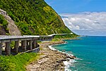 The Patapat Viaduct


See also edit
References edit
- ^ Municipality of Pagudpud | (DILG)
- ^ "2015 Census of Population, Report No. 3 – Population, Land Area, and Population Density" (PDF). Philippine Statistics Authority. Quezon City, Philippines. August 2016. ISSN 0117-1453. Archived (PDF) from the original on May 25, 2021. Retrieved July 16, 2021.
- ^ a b c Census of Population (2020). "Region I (Ilocos Region)". Total Population by Province, City, Municipality and Barangay. Philippine Statistics Authority. Retrieved 8 July 2021.
- ^ "PSA Releases the 2021 City and Municipal Level Poverty Estimates". Philippine Statistics Authority. 2 April 2024. Retrieved 28 April 2024.
- ^ "Municipal Profile | Pagudpud".
- ^ "Pagudpud, Philippines: Average Temperatures and Rainfall". World Weather Online. Retrieved 15 September 2014.
- ^ Census of Population (2015). "Region I (Ilocos Region)". Total Population by Province, City, Municipality and Barangay. Philippine Statistics Authority. Retrieved 20 June 2016.
- ^ Census of Population and Housing (2010). "Region I (Ilocos Region)" (PDF). Total Population by Province, City, Municipality and Barangay. National Statistics Office. Retrieved 29 June 2016.
- ^ Censuses of Population (1903–2007). "Region I (Ilocos Region)". Table 1. Population Enumerated in Various Censuses by Province/Highly Urbanized City: 1903 to 2007. National Statistics Office.
{{cite encyclopedia}}: CS1 maint: numeric names: authors list (link) - ^ "Province of Ilocos Norte". Municipality Population Data. Local Water Utilities Administration Research Division. Retrieved 17 December 2016.
- ^ "Poverty incidence (PI):". Philippine Statistics Authority. Retrieved December 28, 2020.
- ^ "Estimation of Local Poverty in the Philippines" (PDF). Philippine Statistics Authority. 29 November 2005.
- ^ "2003 City and Municipal Level Poverty Estimates" (PDF). Philippine Statistics Authority. 23 March 2009.
- ^ "City and Municipal Level Poverty Estimates; 2006 and 2009" (PDF). Philippine Statistics Authority. 3 August 2012.
- ^ "2012 Municipal and City Level Poverty Estimates" (PDF). Philippine Statistics Authority. 31 May 2016.
- ^ "Municipal and City Level Small Area Poverty Estimates; 2009, 2012 and 2015". Philippine Statistics Authority. 10 July 2019.
- ^ "PSA Releases the 2018 Municipal and City Level Poverty Estimates". Philippine Statistics Authority. 15 December 2021. Retrieved 22 January 2022.
- ^ "PSA Releases the 2021 City and Municipal Level Poverty Estimates". Philippine Statistics Authority. 2 April 2024. Retrieved 28 April 2024.
- ^ "2019 National and Local Elections" (PDF). Commission on Elections. Retrieved March 10, 2022.