The Ogun River (Yoruba: Odò Ògùn) is a waterway in Nigeria that discharges into the Lagos Lagoon.[2][3][4] Ogun State of Nigeria is named after the river.
| Ogun River Odò Ògùn | |
|---|---|
 | |
 | |
| Location | |
| Country | Nigeria |
| Physical characteristics | |
| Source | |
| • elevation | 530 m (1,740 ft) |
| Mouth | |
• location | Lagos |
• elevation | 0 m (0 ft) |
| Length | 480 km (300 mi) |
| Basin size | 23,000 km2 (8,900 sq mi)[1] |
Course and usage edit
The river rises near the towns of Sepeteri and Shaki in upper Oyo State at coordinates 8°41′0″N 3°28′0″E / 8.68333°N 3.46667°E and flows through the rest of the state into Ogun State and eventually into Lagos State where it discharges into the Lagos lagoon at the towns of Isheri and Owode onirin.[5] The river is crossed by the Ikere Gorge Dam in the Iseyin local government area of Oyo State. The reservoir capacity is 690 million cubic metres (560,000 acre⋅ft).[6] The reservoir abuts the Old Oyo National Park, providing recreational facilities for tourists, and the river flows through the park.[7] The Ofiki River, which also rises near Shaki, is the Ogun River's chief tributary.[citation needed][8] The Oyan River, another tributary, is crossed by the Oyan River Dam which supplies water to Abeokuta and Lagos.[9] In densely populated areas the river is used for bathing, washing and drinking. It also serves as a drain for mostly organic wastes from abattoirs located along the river's course.[5]
History edit
In the Yoruba religion, Yemoja is the divinity of the Ogun River. The catechist Charles Phillips, father of the Charles Phillips who later became Bishop of Ondo, wrote in 1857 that the Ogun River was generally worshipped by the people who live along its banks from its rise until where it empties into the lagoon.[10] The river ran through the heart of the old Oyo Empire. Metropolitan Oyo was divided into six provinces with three on the west side of the Ogun River and three to the river's east.[11] At one time, the river formed an important route for traders carrying goods by canoe between Abeokuta and the Lagos Colony.[12]
Gallery edit
-
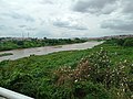 Ogun river in Abeokuta which is referred to as "Odo Ogun" by the locals.
 -

-
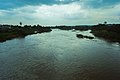 Sunset at Ogun river
 -
 Dawn at Ogun river
 -
 Bridge over Ogun river
 -
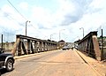 River Ogun bridge entrance
 -
 A meat market called Kara by Ogun river


_(1).jpg)

References edit
- ^ Fluid Flow Interactions in Ogun River, Nigeria
- ^ https://litcaf.com/ogun-river/#0
- ^ "How Each Nigerian State Got Its Name | Zaccheus Onumba Dibiaezue Memorial Libraries". zodml.org. Retrieved 8 August 2023.
- ^ a b A.A. Ayoade, A.A. Sowunmi & H.I. Nwachukwu (2004). "Gill asymmetry in Labeo ogunensis from Ogun river, Southwest Nigeria" (PDF). Rev. Biol. Trop. 52 (1): 171–175. doi:10.15517/rbt.v52i1.14821. PMID 17357414.
- ^ L. Berga, ed. (2006). Dams and Reservoirs, Societies and Environment in the 21st Century: Proceedings of the International Symposium on Dams in the Societies of the 21st Century, 22nd International Congress on Large Dams (ICOLD), Barcelona, Spain, 18 June 2006. Taylor & Francis. p. 314. ISBN 0-415-40423-1.
- ^ "Old Oyo National Park". Nigeria National Park Service. Archived from the original on 16 December 2017. Retrieved 5 November 2010.
- ^ https://www.researchgate.net/figure/Map-of-Ogun-and-Osun-River-Basins-and-the-Adjacent-Basins_fig2_277233312#:~:text=The%20major%20tributaries%20of%20the,season%20between%20April%20and%20October.
- ^ Nigeria, Guardian (22 September 2022). "Flood threat: Ogun border community cries out over opening Oyan River dam". The Guardian Nigeria News - Nigeria and World News. Retrieved 10 July 2023.
- ^ McKenzie, Peter Rutherford (1997). Hail Orisha!: a phenomenology of a West African religion in the mid-nineteenth century. BRILL. p. 30. ISBN 90-04-10942-0.
- ^ Stride, G.T. & C. Ifeka (1971). Peoples and Empires of West Africa: West Africa in History 1000–1800. Edinburgh: Nelson. p. 296. ISBN 0-17-511448-X.
- ^ Foreign and Commonwealth Office (1859). British and foreign state papers, Volume 54. H.M.S.O.