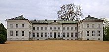
Neuhardenberg is a municipality in the district Märkisch-Oderland, in Brandenburg, Germany. It is the site of Neuhardenberg Palace, residence of the Prussian statesman Prince Karl August von Hardenberg (1750–1822). The municipal area comprises the villages of Altfriedland, Quappendorf and Wulkow. Neuhardenberg is part of the Amt ("collective municipality") Seelow-Land.
Neuhardenberg | |
|---|---|
Location of Neuhardenberg within Märkisch-Oderland district  | |
| Coordinates: 52°36′N 14°15′E / 52.600°N 14.250°E | |
| Country | Germany |
| State | Brandenburg |
| District | Märkisch-Oderland |
| Municipal assoc. | Seelow-Land |
| Subdivisions | Hauptgemeinde und 3 Ortsteile |
| Government | |
| • Mayor (2019–24) | Mario Eska[1] (Ind.) |
| Area | |
| • Total | 77.94 km2 (30.09 sq mi) |
| Elevation | 12 m (39 ft) |
| Population (2022-12-31)[2] | |
| • Total | 2,791 |
| • Density | 36/km2 (93/sq mi) |
| Time zone | UTC+01:00 (CET) |
| • Summer (DST) | UTC+02:00 (CEST) |
| Postal codes | 15320 |
| Dialling codes | 033476 |
| Vehicle registration | MOL |
| Website | www.amt-neuhardenberg.de |

Names of the place edit
The oldest record mentioning the place, then named Quilicz, dates back to 1348. Later the spelling was changed into Quilitz. When in 1814 Karl August von Hardenberg received the manor, he renamed the place right away into Neu-Hardenberg. On Labour Day, 1 May 1949, the precursors of German Democratic Republic renamed it Marxwalde after Karl Marx. This was reversed on January 1, 1991. Since then the place has borne the old name Neuhardenberg (without the hyphen).
History edit
The construction of Neuhardenberg Manor, with interior designs by Carl Gotthard Langhans, dates from the late 18th century. In 1763 the Prussian general Joachim Bernhard von Prittwitz had received Quilitz, a former property of the Pfuel noble family. The historic village was devastated by a blaze in 1801 and reconstructed as a Neoclassical model settlement according to plans by Karl Friedrich Schinkel. In 1814 King Frederick William III vested Hardenberg with the locality together with the princely title as a gratification for his merits as Prussian state chancellor. From 1820 on Schinkel also rebuilt the mansion, while the gardens were redesigned by Prince Hermann von Pückler-Muskau and Peter-Joseph Lenné.
During the Third Reich, the Ministry of Aviation (RLM) used the estate of Count (Graf) Hardenberg to establish an auxiliary airfield known as E-hafen. This was a secret test site for rocket motors and rocket boosters, developed by Hellmuth Walter and Wernher von Braun.[3]
Later, Count von Hardenberg held clandestine meetings at the mansion in preparation for the 20 July plot to kill Hitler. After its failure, he was arrested and his properties were seized by the Nazi authorities. In 1945 Hardenberg again had to face the condemnation of his estates by the Soviet Military Administration. The mansion was turned into a school building. From 1957 on the Marxwalde airfield, built in the 1930s, was extended as the base of an East German Air Force wing.
After reunification the manor was restored to the Hardenberg family and acquired by the Deutscher Sparkassen- und Giroverband saving banks association in 1996. After renovation it was reopened in 2002. It is today used as a conference building but also for cultural events.
Demography edit
|
|
Twin towns edit
References edit
- ^ Landkreis Märkisch-Oderland Wahl der Bürgermeisterin / des Bürgermeisters, accessed 1 July 2021.
- ^ "Bevölkerungsentwicklung und Bevölkerungsstandim Land Brandenburg Dezember 2022" (PDF). Amt für Statistik Berlin-Brandenburg (in German). June 2023.
- ^ Warsitz, Lutz (2008). The First Jet Pilot: The Story of German Test Pilot Erich Warsitz. Barnsley: Pen and Sword aviation. pp. 37–56. ISBN 9781844158188.
- ^ Detailed data sources are to be found in the Wikimedia Commons.Population Projection Brandenburg at Wikimedia Commons
External links edit
Media related to Neuhardenberg at Wikimedia Commons


