Nagakute (長久手市, Nagakute-shi) is a city located in Aichi Prefecture, Japan. As of 1 October 2019[update], the city had an estimated population of 61,503 in 24,352 households,[1] and a population density of 2,854 persons per km2. The total area of the city is 21.55 square kilometres (8.32 sq mi). Nagakute is a member of the World Health Organization’s Alliance for Healthy Cities (AFHC).[2]
Nagakute
長久手市 | |
|---|---|
 Site of Expo 2005 | |
 Flag  Seal | |
 Location of Nagakute in Aichi Prefecture | |
 Nagakute | |
| Coordinates: 35°11′2.4″N 137°02′55.3″E / 35.184000°N 137.048694°E | |
| Country | Japan |
| Region | Chūbu (Tōkai) |
| Prefecture | Aichi |
| Government | |
| • Mayor | Yumi Satō |
| Area | |
| • Total | 21.55 km2 (8.32 sq mi) |
| Population (October 1, 2019) | |
| • Total | 61,503 |
| • Density | 2,900/km2 (7,400/sq mi) |
| Time zone | UTC+9 (Japan Standard Time) |
| - Tree | Maple |
| - Flower | Satsuki azalea |
| Phone number | 0561-63-1111 |
| Address | 60-1 Yazako, Shironouchi, Nagakute-shi, Aichi, Japan 480-1196 |
| Website | Official website |
Geography edit

Nagakute is located in the Owari Hills of central Aichi Prefecture, at an elevation of 43 to 184 meters, and is bordered by the metropolis of Nagoya to the west. Thirteen rivers flow through the city.
Climate edit
The city has a climate characterized by hot and humid summers, and relatively mild winters (Köppen climate classification Cfa). The average annual temperature in Nagakute is 15.5 °C. The average annual rainfall is 1641 mm with September as the wettest month. The temperatures are highest on average in August, at around 27.9 °C, and lowest in January, at around 4.0 °C.[3]
Demographics edit
Per Japanese census data,[4] the population of Nagakute has increased dramatically over the past 50 years. The median age of a population in 2020 was 40.2 years old, the youngest in Japan.
| Year | Pop. | ±% |
|---|---|---|
| 1940 | 5,138 | — |
| 1950 | 6,638 | +29.2% |
| 1960 | 6,639 | +0.0% |
| 1970 | 11,317 | +70.5% |
| 1980 | 18,610 | +64.4% |
| 1990 | 33,714 | +81.2% |
| 2000 | 43,306 | +28.5% |
| 2010 | 52,399 | +21.0% |
| 2020 | 60,162 | +14.8% |
Neighboring municipalities edit
History edit
Middle Ages edit
During the Sengoku period, the Battle of Komaki and Nagakute was held in this vicinity.
Early modern period edit
During the Edo period area of modern Nagakute was part of the holdings of Owari Domain.
Late modern period edit
Nagakute Village was established within Aichi District on May 10, 1906, through the merger of the hamlets of Nagakute (different spelling as 長湫村), Kamigō and Yazako.
Contemporary history edit
Nagakute was elevated to town status on April 1, 1971.
Expo 2005 was a major boost to the local economy, and led to the construction of the Linimo, a commercial linear motor train, to connect the area with the Nagoya metropolis.
The Nagakute hostage incident occurred within the town limits in May 2007.
Nagakute was elevated to city status on January 4, 2012.[5]
Government edit

Nagakute has a mayor-council form of government with a directly elected mayor and a unicameral city legislature of 18 members. The city contributes one member to the Aichi Prefectural Assembly. In terms of national politics, the city is part of Aichi District 7 of the lower house of the Diet of Japan.
External relations edit
Twin towns – Sister cities edit
International edit
- Sister cities
 Waterloo (Walloon Brabant, Belgium)
- since October 8, 1992[6]
National edit
- Friendship city
 Nagiso (Nagano Prefecture, Chūbu region)
- since October 21, 2006
 Takarazuka (Hyōgo Prefecture, Kansai region)
- since October 27, 2012
Economy edit
Secondary sector of the economy edit
Manufacturing edit
Due to its location, Nagakute's economy is centered around the automobile industry. Toyota Central R&D Labs., Inc. is located in the city, as is electrical systems manufacturer Nitto Kogyo. Nagakute is also the head office of the Aichi Rapid Transit Co., Ltd., better known as the operator of the Linimo Maglev High Speed Surface Transport.
Education edit
University edit

- Aichi Prefectural University
- Aichi Prefectural University of Fine Arts and Music
- Aichi Medical University
- Aichi Shukutoku University
Primary education edit
- Nagakute has six public elementary schools and three public junior high schools operated by the city government, and one public high school operated by the Aichi Prefectural Board of Education. There is also one private high school.
International Schools edit
Transportation edit


Railways edit
Conventional lines edit
- Tōbu Kyūryō Line: - Hanamizuki-dōri – Irigaike-kōen – Nagakute Kosenjō – Geidai-dōri – Kōen-nishi – Aichikyūhaku-kinen-kōen -
Buses edit
- The Meitetsu Bus, which serves Nagakute and the surrounding municipalities, operates the Nagoya depot within the city limits.
- Nagakute is also served by the N-Bus, which is a community bus owned by the city of Nagakute and operated by Meitetsu Bus.
-
 Meitetsu Bus Nagoya Depot
 -
 N-Bus
N-Bus


Roads edit
Expressways edit
- The Nagoya Seto Expressway, which is designated as a Regional High-Standard Highway, starts from Nagakute and funnels traffic in to the Tōmei Expressway, which passes through Nagakute has no interchange within city limits. However, the Nagoya Interchange, which serves the Tomei and Mei-Nikan Expressways, is close to city limits.
Local attractions edit
- Toyota Automobile Museum
- Meito Art Museum
- Expo 2005 Site
- Site of the Battle of Komaki and Nagakute
- Ghibli Park
-
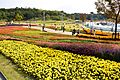 Site of Expo 2005
 -
 Toyota Automobile Museum
 -
 Iroganeyama Historical park
 -
 Nagakute Historic Battleground Park


Notable people from Nagakute edit
- Shinta Fukushima, professional soccer player
- Mine Kawakami, pianist
References edit
- ^ Nagakute City official statistics (in Japanese)
- ^ Alliance for Healthy Cities official home page
- ^ Nagakute climate data
- ^ Nagakute population statistics
- ^ "「平成24年1月4日長久手市誕生!」". Nagakute City (in Japanese). December 11, 2013. Archived from the original on December 4, 2014. Retrieved July 1, 2023.
{{cite web}}: CS1 maint: unfit URL (link) - ^ "International Exchange". List of Affiliation Partners within Prefectures. Council of Local Authorities for International Relations (CLAIR). Archived from the original on December 24, 2015. Retrieved November 21, 2015.
External links edit
![]() Media related to Nagakute, Aichi at Wikimedia Commons
Media related to Nagakute, Aichi at Wikimedia Commons
- Official website (in Japanese)