The Monte San Salvatore (912 m) is a mountain in the Lepontine Alps above Lake Lugano and the city of Lugano in Switzerland. The Monte San Salvatore funicular links the city with the summit of the mountain.
| Monte San Salvatore | |
|---|---|
 | |
| Highest point | |
| Elevation | 912 m (2,992 ft) |
| Prominence | 602 m (1,975 ft)[1] |
| Isolation | 2.96 km (1.84 mi) |
| Coordinates | 45°58′37.3″N 8°56′50.1″E / 45.977028°N 8.947250°E |
| Geography | |
 Monte San Salvatore Location in Switzerland | |
| Location | Ticino, Switzerland |
| Parent range | Lugano Prealps |
| Climbing | |
| Easiest route | Hike or ride Monte San Salvatore funicular |
One of the villages on the slopes of Monte San Salvatore, Carona, is a popular destination to enjoy views over Lake Lugano and to walk through the exotic plants and flowers of Parco San Grato.[2]
Gallery edit
-
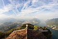 View of Lugano and its surroundings from Monte San Salvatore.
 -
 View of Lake Lugano from Monte San Salvatore, with Lugano to the left and the Melide causeway to the right
 -
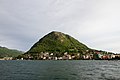 Monte San Salvatore, as seen from Piazza Luini, Lugano.
 -
 Monte San Salvatore at Night seen from Gandria


See also edit
References edit
External links edit
- Monte San Salvatore funicular railway web site
- Monte San Salvatore on Hikr
 Media related to Monte San Salvatore at Wikimedia Commons
This article about a mountain, mountain range, or peak located in Ticino is a stub. You can help Wikipedia by expanding it. |