Monte Isola (also known by the name of the main island Montisola; Brescian: Muntìsola) is a town and comune in the province of Brescia, in Lombardy. It is one of I Borghi più belli d'Italia ("The most beautiful villages of Italy").[2]
Monte Isola
Muntìsola | |
|---|---|
| Comune di Monte Isola | |
.jpg) Monte Isola | |
 Coat of arms | |
Location of Monte Isola  | |
 Monte Isola Location of Monte Isola in Italy  Monte Isola Monte Isola (Lombardy) | |
| Coordinates: 45°43′N 10°05′E / 45.717°N 10.083°E | |
| Country | Italy |
| Region | Lombardy |
| Province | Brescia (BS) |
| Frazioni | Corzano, Cure, Masse, Menzino, Novale, Olzano, Peschiera Maraglio, Porto di Siviano, Sensole, Senzano, Sinchignano, Siviano |
| Government | |
| • Mayor | Fiorello Turla |
| Area | |
| • Total | 12.8 km2 (4.9 sq mi) |
| Elevation | 275 m (902 ft) |
| Population (2015)[1] | |
| • Total | 1,770 |
| • Density | 140/km2 (360/sq mi) |
| Demonym | Montisolani |
| Time zone | UTC+1 (CET) |
| • Summer (DST) | UTC+2 (CEST) |
| Postal code | 25050 |
| Dialing code | 030 |
| Patron saint | Sts. Faustino and Jovita |
| Saint day | 15 February |
| Website | Official website |
It is located on the islands Montisola (the major island, from which it takes the name), Loreto and San Paolo in Lake Iseo and, as of 2015[update], its population is 1,770.[3] Monte Isola's population is approximately spread over eleven villages and hamlets. There are several churches built between the 15th and the 17th century with frescoes, statues, altars in vernacular art.
Geography edit
The municipality covers a total area of 12.8 square kilometres (4.9 sq mi); the main island, Monte Isola, with an area of 4.5 square kilometres (1.7 sq mi) ranks as the largest lake island not only in Italy, but also in South and Central Europe, but is dwarfed by the large lake islands in Northern Europe. The peak of the island at 600 metres (1,969 feet) above sea level is 415 metres (1,362 feet) above the average surface elevation of Lake Iseo (185 m (607 ft)), making Monte Isola one of the highest lake islands in Europe.
Monte Isola includes 12 frazioni: Carzano, Cure, Masse, Menzino, Novale, Olzano, Peschiera Maraglio, Porto di Siviano, Sensole, Senzano, Sinchignano and Siviano.
The bordering municipalities are Iseo, Marone, Sale Marasino, Sulzano, Parzanica, Tavernola Bergamasca and Sarnico.
There are two main ports Carzano and Peschieria with a frequent ferry service with the surrounding mainland villages, including Iseo.
History edit
There are indications of a Roman settlement. The first written document mentioning "Insulae curtis" dates from 905, when the island was listed among the properties of the monastery of S. Salvatore in Brescia. The family Oldofredi, rulers of Iseo, built on the island two strongholds in the 11th-12th centuries. Members of the powerful Visconti family came here to hunt in 1400. In 1497 Francesco Sforza, duke of Milan, gave the islanders some fishing rights and reduced the taxes. In the same year, Caterina Cornaro, queen of Cyprus, resided a while on the island. During the 19th century the main industry on the island was the construction of boats and the manufacturing of fishing nets.
Peschiera Maraglio and Siviano (the municipal seat)[4] merged in 1929 to create the actual comune.
In June and early July, 2016, Monte Isola was the site of The Floating Piers by artists Christo and Jeanne-Claude.
Main sights edit
The single-nave church of San Michele in Peschiera Maraglio was consecrated in 1648. This baroque church is notable for the many frescoes on the walls and on the ceiling and for its wooden carvings.
The shrine of Madonna della Ceriola stands 600 metres (1,969 feet) above sea level, the highest spot on the island. It can only be reached by walking from the small village of Cure.
The fortress Martinengo can be reached from Menzino. It was built in the 15th century by the Oldofredi family and enlarged in the 16th century by Martinengo. After a long period of neglect, it has been renovated in an elegant residence by the architect Vittorio Faglia. In 1497 Catherine Cornaro, queen of Cyprus, sojourned here for a short stay.
Transportation edit
Monte Isola can be reached through a network of ferry connection with regular schedules.[5]
Driving restrictions are currently enforced, with mopeds and bicycles only allowed on the island. An extensive grid of dedicated bike lanes and hiking trails span all over the island, reaching the peaceful fishing villages with lakeside cafés and the Madonna della Ceriola chapel, nested near the summit of the island. A circular trail of almost 9 km (6 mi) allows a complete tour of Monte Isola.
A regular bus service, with special buses, is operated by the municipality of Monte Isola.
Photogallery edit
-

-
 View of Siviano
 -
 Southern view of Lake Iseo, with Peschiera Maraglio and Sulzano
 -
 The shrine of Madonna della Ceriola in the highest point of the island
 -
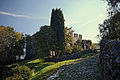 The fortress of Monte Isola
 -
 The streets of Monte Isola decorated with flowers during the Holy Cross week in September
 -
 View of the port in Peschiera Maraglio
 -
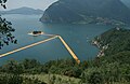 View from Montisola of The Floating Piers and the San Paolo isle in the middle, Gallinarga (Tavernola Bergamasca, province of Bergamo) in the left side of the background, and Clusane (Iseo, BS) in the right side of the background, 2016


References edit
- ^ "Popolazione Residente al 1° Gennaio 2018". Italian National Institute of Statistics. Archived from the original on 30 June 2019. Retrieved 16 March 2019.
- ^ "Lombardia" (in Italian). Retrieved 31 July 2023.
- ^ (in Italian) Source: Istat 2015
- ^ (in Italian) Town hall address on municipal website
- ^ "Orari traghetti Montisola". Navigazione Lago d'Iseo (in Italian). Retrieved 6 May 2015.
External links edit
![]() Media related to Monte Isola at Wikimedia Commons
Media related to Monte Isola at Wikimedia Commons