The following is a summary of significant earthquakes during the 21st century. In terms of fatalities, the 2004 Indian Ocean earthquake was the most destructive event with 227,898 confirmed fatalities, followed by the 2010 Haiti earthquake with about 160,000 fatalities,[2] the 2008 Sichuan earthquake with 87,587 fatalities, the 2005 Kashmir earthquake with 87,351 fatalities, and the 2023 Turkey–Syria earthquakes with at least 59,488 fatalities.

The 2011 Tōhoku earthquake and tsunami became the costliest natural disaster, resulting in approximately $360 billion in property damage at the time, followed by the 2023 Turkey–Syria earthquakes and the 2008 Sichuan earthquake, which resulted in $163.6 billion and $150 billion in damage, respectively.
List of deadliest earthquakes edit
- Note: At least 1,000+ fatalities
List of largest earthquakes by magnitude edit
| Rank | Magnitude[7] | Event | Location | Date |
|---|---|---|---|---|
| 1 | 9.1–9.3 | 2004 Indian Ocean earthquake | December 26, 2004 | |
| 2 | 9.0–9.1 | 2011 Tōhoku earthquake | March 11, 2011 | |
| 3 | 8.8 | 2010 Chile earthquake | February 27, 2010 | |
| 4 | 8.6 | 2005 Nias–Simeulue earthquake | March 28, 2005 | |
| 4 | 8.6 | 2012 Indian Ocean earthquakes | April 11, 2012 | |
| 5 | 8.5 | September 2007 Sumatra earthquakes | September 12, 2007 |
- Note: At least 8.5+ magnitude
List of costliest earthquakes edit
Note:This only ranks immediate costs, for example, nuclear meltdown and climate and fossil fuel costs, as well as other ongoing costs from quakes are not included.
| Rank | Event | Location | Magnitude | Historic cost (year) | Adjusted for inflation (year) |
|---|---|---|---|---|---|
| 1 | 2011 Tōhoku earthquake and tsunami | 9.1[8] | $235 billion (2011)[9] | $320.4 billion (2023) | |
| 2 | 2023 Turkey–Syria earthquake | 7.8 and 7.7 Mw | $163.3 billion (2023)[10][11] | $163.3 billion (2023) | |
| 3 | 2008 Sichuan earthquake | 8.0 Ms | $150 billion (2008)[12] | $212.3 billion (2023) | |
| 4 | 2010 Canterbury earthquake | 7.0 | $40 billion (2010)[13] | $56.2 billion (2023) | |
| 5 | 2004 Chūetsu earthquake | 6.8 | $28 billion (2004)[14][15] | $45.1 billion (2024) | |
| 6 | 2011 Sikkim earthquake | 6.9 | $22.3 billion (2011)[16] | $30.2 billion (2024) | |
| 7 | 2016 Kumamoto earthquakes | 7.0 | $24-46 billion (2016)[17] | $30.5-58.4 billion (2024) | |
| 8 | 2024 Noto earthquake | 7.5 | $17.6 billion (2024)[18] | $17.6 billion (2024) | |
| 9 | 2009 L'Aquila earthquake | 6.3 | $16 billion (2009)[19] | $22.7 billion (2024) | |
| 10 | 2012 Northern Italy earthquakes | 6.1[20] | $15.8 billion (2012)[21] | $20.9 billion (2024) |
Deadliest earthquakes by year edit
These are the deadliest earthquakes per year[22]
Largest earthquakes by year edit
These are the largest earthquakes by magnitude per year[7]
Lists of earthquakes by decade edit
Gallery edit
- 21st-century earthquakes gallery
-
 The 2001 Gujarat earthquake occurred in a part of India with relatively low seismicity, devastating the cities of Anjar and Bhuj.
 -
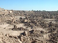 The 2003 Bam earthquake destroyed several historic landmarks, including a citadel.
 -
 The 2004 Indian Ocean tsunami is one of the deadliest natural disasters in recent history.
 -
 The 2005 Kashmir earthquake destroyed several towns, and caused extensive damage and landslides as far as the Pakistani capital Islamabad.
 -
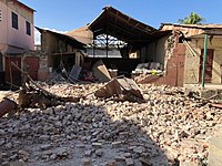
 The 2006 Yogyakarta earthquake was a fairly moderate event, but caused widespread damage across eastern Java.
 -
 The 2007 Peru earthquake caused severe damage in the city of Pisco, and was the deadliest in the country since 1970.
 -
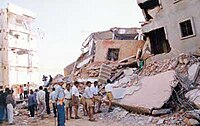
 The 2008 Sichuan earthquake was the costliest earthquake in Chinese history, with over $150 billion USD.
 -

-
 The 2010 Haiti earthquake was the most destructive compared to its magnitude, due to poorly constructed buildings and the earthquake's proximity to the capital Port-au-Prince.
 -
 The 2011 Christchurch earthquake was a shallow event and very close to the city, resulting in extensive damage to population centers.
 -
 The 2011 Tōhoku earthquake and tsunami caused a nuclear meltdown at Fukushima Daiichi Nuclear Plant, resulting in the costliest natural disaster of all time.
 -
 The 2012 East Azerbaijan earthquakes severely affected 150 villages and killed hundreds of people.
 -
 The 2015 Nepal earthquake caused extensive damage in Kathmandu and triggered the deadliest avalanche on Mount Everest.
 -

-
 The 2021 Haiti earthquake was the country's largest earthquake in its modern history.
 -
 The June 2022 Afghanistan earthquake caused severe destruction and many villages were destroyed.
 -
 The 2022 West Java earthquake killed hundreds and destroyed tens of thousands of houses, despite its moderate magnitude.
 -

-
 The 2023 Al Haouz earthquake was one of the deadliest and the most powerful earthquake ever recorded in modern-day Morocco.
 -
 The 2024 Noto earthquake was Japan's deadliest since 2016, with the towns of Suzu and Wajima largely destroyed.


.jpg)


.JPG)


See also edit
Notes edit
References edit
- ^ "USGS: Magnitude 8 and Greater Earthquakes Since 1900". Archived from the original on November 12, 2009. Retrieved October 1, 2014.
- ^ Kolbe, Athena R.; Hutson, Royce A.; Shannon, Harry; Trzcinski, Eileen; Miles, Bart; Levitz, Naomi; Puccio, Marie; James, Leah; Roger Noel, Jean; Muggah, Robert (2010). "Mortality, crime and access to basic needs before and after the Haiti earthquake: a random survey of Port-au-Prince households". Medicine, Conflict and Survival. 26 (4): 281–297. doi:10.1080/13623699.2010.535279. PMID 21314081. S2CID 26000167.
- ^ Kolbe, Athena R.; Hutson, Royce A.; Shannon, Harry; Trzcinski, Eileen; Miles, Bart; Levitz, Naomi; Puccio, Marie; James, Leah; Roger Noel, Jean; Muggah, Robert (2010). "Mortality, crime and access to basic needs before and after the Haiti earthquake: a random survey of Port-au-Prince households". Medicine, Conflict and Survival. 26 (4): 281–297. doi:10.1080/13623699.2010.535279. PMID 21314081. S2CID 26000167.
- ^ "After 17 Years Iran Finally Announces 34,000 Died In Bam Earthquake". Iran International. December 26, 2020. Retrieved February 24, 2023.
- ^ World Health Organization (October 16, 2023). "Afghanistan Earthquakes in Herat Province, Health Situation Report No. 8, 15-16 October 2023". ReliefWeb. Archived from the original on October 18, 2023. Retrieved October 17, 2023.
- ^ Yeats, Robert S.; Madden, Christopher (2003). "Damage from the Nahrin, Afghanistan, Earthquake of 25 March 2002". Seismological Research Letters. 74 (3): 305–311. doi:10.1785/gssrl.74.3.305.
- ^ a b ISC 2022.
- ^ "M 9.1 – near the east coast of Honshu, Japan". Earthquake Hazards Program. USGS. 2016. Retrieved November 21, 2016.
- ^ Victoria Kim (March 21, 2011). "Japan damage could reach $235 billion, World Bank estimates". Los Angeles Times. Archived from the original on March 31, 2011. Retrieved March 21, 2011.
- ^ "Deprem bölgesinde fatura borçlarının silinmesi için süre uzatıldı". Milat Gazetsi. August 22, 2023. Retrieved November 9, 2023.
- ^ "Political failure has killed people in Syria before and after the earthquakes". Counsil for Arab-British Understanding. April 10, 2023. Retrieved April 14, 2023.
- ^ Watts, Jonathan (August 15, 2008). "Sichuan quake: China's earthquake reconstruction to cost $150bn". The Guardian. Retrieved January 27, 2024.
- ^ "Four years on: Insurance and the Canterbury Earthquakes" (PDF). Deloitte Access Economics. February 2015. Archived from the original (PDF) on January 24, 2016. Retrieved February 29, 2016.
- ^ "Significant Earthquake Database". NOAA National Centers for Environmental Information. National Oceanic and Atmospheric Administration. Retrieved May 20, 2015.
- ^ Guha-Sapir, Debarati; Santos, Indhira; Borde, Alexandre (2013). The Economic Impacts of Natural Disasters. Oxford: Oxford University Press. p. 252. ISBN 978-0-19-984193-6.
- ^ Santanu Baruah; Sowrav Saikia; Saurabh Baruah; Pabon K. Bora; Ruben Tatevossian; J. R. Kayal (March 19, 2014). "The September 2011 Sikkim Himalaya earthquake Mw 6.9: is it a plane of detachment earthquake?". Geomatics, Natural Hazards and Risk. 7: 248–263. doi:10.1080/19475705.2014.895963. S2CID 128915677. Retrieved August 1, 2022.
- ^ "2016 Kumamoto Earthquake Survey Report (Preliminary)" (PDF). Asian Disaster Reduction Center. Retrieved January 27, 2024.
- ^ "Gov't estimates central Japan quake damage will reach 2.6 tril. yen". Kyodo News. January 26, 2024. Retrieved January 26, 2024.
- ^ "Italy Quake Reconstruction to Cost at Least $16 Billion". Fox News. April 15, 2009. Archived from the original on April 19, 2009. Retrieved October 23, 2012.
- ^ "Where can I learn more about the 1906 Earthquake?". Berkeley Seismological Lab. December 11, 2011.
- ^ National Geophysical Data Center / World Data Service (NGDC/WDS) (1972). "Significant Earthquake Database". Significant Earthquake Database (Data Set). National Geophysical Data Center, NOAA. doi:10.7289/V5TD9V7K.
- ^ "Global earthquake death toll from 2000 to 2015". Statista.com. Retrieved December 3, 2019.
Sources
- ISC (2022), ISC-GEM Global Instrumental Earthquake Catalogue (1904–2018), Version 9.1, International Seismological Centre