Lewesdon Hill is a hill in west Dorset, England. With a maximum elevation of 279 m (915 ft), it is the highest point in Dorset.[1][2]
| Lewesdon Hill | |
|---|---|
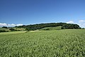
 Lewesdon Hill from the west | |
| Highest point | |
| Elevation | 279 m (915 ft)[1] |
| Prominence | 185 m (607 ft) |
| Parent peak | Staple Hill |
| Listing | Marilyn, Hardy, County Top |
| Coordinates | 50°48′28″N 2°47′59″W / 50.8077°N 2.7996°W |
| Geography | |
 Lewesdon Hill Lewesdon Hill in Dorset | |
| Location | Dorset, England |
| OS grid | ST437011 |
| Topo map | OS Landranger 193 Explorer 116 |
| Climbing | |
| Easiest route | From Beaminster on the Wessex Ridgeway |
Geography edit
Location edit
Lewesdon Hill stands about 4 km west of Beaminster, 1½ km south of Broadwindsor, 2 miles south of Mosterton, 1½ km west-northwest of Stoke Abbott and 3 km east of another hillfort-topped eminence, Pilsdon Pen. To the south of the hill is the Marshwood Vale and to the north is the valley of the River Axe.
Summit edit
Lewesdon is the county top of Dorset.[1] Its summit is an elongated ridge surrounded by beech woods. The actual summit is a low grassy mound at the east end of the ridge.[3] For many years, nearby Pilsdon Pen (277 m) was thought to be Dorset's highest hill, until modern survey revealed that Lewesdon Hill was 2 metres higher.[2] Dorset's third highest point is Bulbarrow Hill (274 m). Lewesdon's topographic prominence of 185 metres qualifies it as a Marilyn.[3]
Geology edit
The hill is formed from upper greensand which is more resistant to erosion than the surrounding clay.
History edit
Many of the high hills in Dorset, including its neighbour Pilsdon Pen, are sites of an Iron Age hillfort. However Lewesdon's status as a hillfort is disputed, partly due to its small size and lack of any clear evidence. Parts of a possible bank and ditch are still visible although they have been disturbed or created by gravel quarrying and timber removal.[4] The remains of the hillfort are a scheduled monument.[5]
Lewesdon was also the site of one of the Armada Beacons in 1588 used to warn of impending attack by Spain.[4]
Access edit
It is a National Trust property.[6] There are two main footpaths leading up to the summit, one from the village of Broadwindsor, and one from Coombe Lane (off the B3162 between Broadwindsor and Bridport, just before the Four Ash crossroads). The Coombe Lane footpath leads to the hill via another, smaller hill, Crabb's Hill, which is privately owned. The east–west footpath is part of the Wessex Ridgeway.[7]
1942 Spitfire Crash edit
Jean Verdon Marie Aime Decloedt was born in the St Giles district of London to parents working at the Belgian Embassy, Prosper & Jeanne Decloedt.[8][9] Jean was an engineer in the Belgian Air Component in 1940, which he left to join the Royal Air Force Reserves. He trained with the No.5 Flying School at MOD Sealand, and joined the 37 Maintenance Unit, Burtonwood at RAF High Ercall.[9] Part of the deployment was to deliver Supermarine Spitfires around England as replacements.[10]
On Sunday the 15th of March 1942 in the early afternoon, Jean entered his Spitifre Mk Vb BL463 (Berar 1), with the intention of delivering it to RAF Bolt Head.[9] His path crossed over the hill and the nearby village of Broadwindsor, where, at 18:15, an aircraft's engine was heard spluttering. The impact into the north hillside killed Jean in an instant.[10] The commonly accepted reason for the crash is the fog in the area, which had already downed 20 planes from the Polish 317 Squadron (the squadron he was delivering the Spitfire to).

Three Home Guard members, Jack Frampton, Jack Wakely, and John Studley, were on guard that night, and climbed the hill to investigate. They found Jean's body, however the incident was kept secret by the MOD to not damage local morale.[10][11] The body was taken to the Bridport Hospital Mortuary and buried at Brookwood Cemetery in Surrey, before being given to Brussels on Thursday October 20, 1949, 219 days after the crash. He received a headstone at Brussels Cemetery.[9] One of the propellers was found by Dudley Tolley, a Home Guard and farmer in the area. He kept it under his bed for 75 years before donating it to the Beaminster Museum [1], where it now hangs.
Jean is known as "The Forgotten Pilot" in the area, as his legacy and the crash were forgotten after the 1960's after the initial memorial was overgrown. Andrew Framptom bought the name to public attention after a COVID infection forced him to stay home. He gathered funding and help from the National Trust and organised a memorial service on Tuesday, 15 March 2022, during which a new, permanent memorial was unveiled.[8]
References edit
- ^ a b c Bathurst, David (2012). Walking the county high points of England. Chichester: Summersdale. pp. 119–125. ISBN 978-1-84-953239-6.
- ^ a b Muir, Johnny, The UK's County Tops, Milnthorpe: Cicerone, 2011, p. 26. ISBN 978-1-85284-629-9
- ^ a b Lewesdon Hill at www.hill-bagging.co.uk. Retrieved 18 Jun 2017.
- ^ a b Lewesdon Hill[permanent dead link] at www.dorsetforyou.gov.uk. Retrieved 18 June 2017
- ^ Historic England. "Lewesdon hillfort, 525m north east of Brimbley Coombe Farm, Broadwindsor (1017034)". National Heritage List for England. Retrieved 1 December 2021.
- ^ "Lewesdon Hill". National Trust. Retrieved 28 February 2022.
- ^ OS Landranger 193, 1:50,000 series.
- ^ a b Shields, Wendy (16 March 2022). "The Lost Pilot Ceremony". Broadwindsor.org. Retrieved 2 December 2023.
- ^ a b c d "#WW2 Archives". Broadwindsor.org. 7 June 2023. Retrieved 2 December 2023.
- ^ a b c "MNA194108 | National Trust Heritage Records". MNA194108 | National Trust Heritage Records. Archived from the original on 2 December 2023. Retrieved 2 December 2023.
- ^ "Memorial unveiled following investigation into identity of 'Forgotten Pilot'". Dorset Echo. 17 March 2022. Retrieved 2 December 2023.
Gallery edit
-
 Lewesdon Hill from the south
 -
 View of Lewesdon Hill from Leweston Farm in 1963
 -
 A view of the gate from the Broadwindsor path, with the Spitfire memorial in the bottom right


