The Menindee Lakes is a system of 9 large, but relatively shallow lakes, located in south-west New South Wales on the Darling (Barka) River, about 200 km upstream of the Darling River's junction with the River Murray. The Darling River is fed by nine major tributary river systems flowing from south-east Queensland and north and central NSW. The town of Menindee is close to the lakes and the nearest city is Broken Hill.[4]
| Menindee Lakes | |
|---|---|
 Satellite photo of Menindee Lakes | |
 Menindee Lakes | |
| Location | Far West, New South Wales |
| Coordinates | 32°20′59″S 142°22′08″E / 32.34972°S 142.36889°E |
| Lake type | Ephemeral fresh water |
| Primary inflows | Darling River |
| Primary outflows | Darling River |
| Catchment area | 273,229 square kilometres (105,494 sq mi) |
| Basin countries | Australia |
| Managing agency | Murray Darling Basin Authority |
| Designation | National park: Kinchega |
| Built | 1949 |
| First flooded | 1968 |
| Max. length | 16 kilometres (9.9 mi) (Lake Menindee only) |
| Max. width | 14 kilometres (8.7 mi) (Lake Menindee only) |
| Surface area | 47,500 hectares (117,000 acres) |
| Average depth | 7 metres (23 ft) |
| Water volume | 1,731,000 megalitres (1.403×10⁶ acre⋅ft) |
| Surface elevation | 60 metres (200 ft) AHD |
| Settlements | Menindee |
| References | [1][2][3] |
There are 4 main lakes in the system:
- Lake Wetherell
- Lake Pamamaroo
- Lake Menindee (the largest lake, also known as Lake Minandichi[5])
- Lake Cawndilla.
The lakes rely on replenishment, when water flows over the banks of the Darling (Barka) River.[4] The NSW Government modified the lakes (completed 1968) to improve their storage capacity for farming, recreation, mining and urban water supply and to help manage floods in the Darling River. In the 1960s, governments decided to use some of the lakes as water storages, building a large weir (Main Weir) to divert water into lakes Pamamaroo, Tandure and Bijijie. Levees, block dams and channels were built to regulate the flow of water in the system. There is relatively little information on the flooding regimes of the lakes before they were regulated (dammed) in the 1960s but they were undoubtedly highly productive and important wetland systems where many fish were spawned.[4]
The Menindee Lakes Water Storage Scheme supplies water to Broken Hill, the lower Darling and to water users along the Murray River in New South Wales, Victoria and South Australia under the Murray-Darling Basin Agreement. Seven of the lakes have been incorporated in an artificially regulated overflow system providing both for flood mitigation and as storage for domestic use, livestock and irrigation downstream. The lakes are also important for waterbirds.
Recent research (Thoms and Delong 2018) found that the food webs have changed in a way that suggests that the ecological resilience of the system has declined.[4]
The lakes were filled to capacity in 2021 with Lakes Cawndilla and Lake Menindee filling completely in early September meaning that the system was filled to over 98 per cent capacity with water flowing into Lake Speculation for the first time since 2012.[6]
People of the Barka edit
The first people living around the Menindee Lakes area are known as the Barkindji or Paakantyi. The original inhabitants gained Native Title over the area in 2015, but it didn't include control of water use on the Darling (Barka) River. In January 2019, ABC News wrote the Chairperson of the Menindee Barkandji Elders Group, Patricia Doyle, called for better water management in the area. "The government needs to adopt a whole-system approach to water management in the Darling River," she said.[1]
Fish deaths edit
There have been periods of mass fish deaths in the Lakes. Fish kill data from the NSW Fisheries Department shows the size of the sudden deaths, after 1960 to be much greater. Between December 2018 and January 2019, and again in late 2022 and early 2023, there were at least 5 mass fish deaths reported along a 40-km stretch of the Darling River,[7][8][9] downstream of the Menindee Lakes. These are often described as the "Menindee Lakes fish kill". It is estimated at least a million fish died, most affected were bony herring, Murray cod, silver perch and golden perch. The Australian government report on the deaths determined three main causes: inadequate water flow in the Darling River, poor water quality and a sudden change in temperature.[10]
Another report, commissioned by the government opposition leader Mr Bill Shorten MP, concluded the deaths were the result of low water flows and hot temperatures causing blue-green algal blooms. The algae depleted oxygen in the river, depriving the fish of necessary oxygen to live. The report also stated, "The conditions leading to this event are an interaction between a severe (but not unprecedented) drought and, more significantly, excess upstream diversion of water for irrigation. Prior releases of water from Menindee Lakes contributed to lack of local reserves."[4]
Location and features edit

The lakes are located approximately 110 kilometres (68 mi) south-east of Broken Hill[1] in the semi-arid zone on grey clay and duplex soils, and siliceous and calcareous sands of the far west region.
The lakes range in size from 103–15,900 hectares (250–39,290 acres). The largest are Lakes Menindee, Wetherell, Pamamaroo and Cawndilla. These four, with Tandure, Bijijie and Balaka, are part of the Menindee Lakes Water Storage Scheme, with Cawndilla and Menindee also within the Kinchega National Park. Lakes Nettlegoe, Kangaroo, Stir Tank, New and Malta are unregulated. Lake Tandou is managed as irrigated cropland and is no longer subject to flooding.
The shallow margins of the overflow lakes are studded with dead black box trees while the shores are dominated by bluerod and sandhill canegrass.[11]
Menindee Lakes Storages edit

The Menindee Lakes Storages is a major gated dam, including multiple weir and lake impoundments and a concrete spillway, with six vertical lift gates, across the seven lakes that form part of the Menindee Lakes Water Storage Scheme. The lakes were originally a series of natural depressions that filled during floods. As the flow receded the floodwaters in the natural depressions drained back into the Darling River.[2]
In 1949, work began on building dams, weirs, levees, canals and regulators to catch and retain floodwaters. Major works were completed in 1960 and final completion was in 1968. There were electrical upgrades in 2007. The scheme was built by the New South Wales Water Conservation and Irrigation Commission, to manage river flows, town water supplies and other domestic requirements, irrigated agriculture, industry, and flood mitigation. It has become increasingly important for regulating environmental flows.[1][2][3]
Construction of the retaining walls required 103 cubic metres (3,600 cu ft) of rock fill, 18 metres (59 ft) high and 95 metres (312 ft) long. The average water depth is 7 metres (23 ft) and, at 100% capacity, the dam walls hold back 1,731,216 megalitres (61,137.3×106 cu ft) of water at an average of 60 metres (200 ft) above sea level. The surface area of the lakes within the scheme is 47,500 hectares (117,000 acres) and the combined catchment area is 273,226 square kilometres (105,493 sq mi). The uncontrolled concrete spillway with six vertical lift gates is capable of discharging water at 850 cubic metres per second (30,000 cu ft/s).[1][2][3]
Birds edit
Some 423 km2 (163 sq mi) of the lakes and their surrounds, with the exception of Lake Tandou, have been identified by BirdLife International as an Important Bird Area (IBA) because it has supported up to 222,000 waterbirds, including over 1% of the world populations of freckled ducks, grey teals, pink-eared ducks, red-necked avocets, sharp-tailed sandpipers and red-capped plovers.[12] Other waterbirds sometimes using the lakes in large numbers are Australasian shovellers, Australian shelducks, pied cormorants, yellow-billed spoonbills, Eurasian coots and white-headed stilts. Other species recorded in the IBA include Australian bustard, black and pied honeyeaters, chirruping wedgebill and grey falcon.[11]
See also edit
Gallery edit
-
 The lakes are important for grey teals
 -
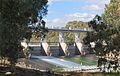 Main Weir on the Darling River at the Menindee Lakes, 2009.
 -
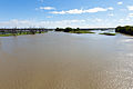 Menindee Lakes viewed from the Main Weir, 2012.
 -
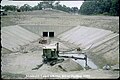
 Dam construction, 1959.
 -
 Construction at Menindee Lakes Scheme, 1959.


References edit
- ^ a b c d "Menindee Lakes Storages". Water delivery: storages. State Water Corporation. Retrieved 23 April 2013.
- ^ a b c d "Menindee Lakes" (PDF brochure). State Water Corporation. 2009. Retrieved 23 April 2013.
- ^ a b c "Register of Large Dams in Australia". Dams information. The Australian National Committee on Large Dams Incorporated. 2010. Archived from the original (Excel (requires download)) on 12 December 2013. Retrieved 23 April 2013.
- ^ a b c d e Moritz, Craig (February 2019). "Investigation of the causes of mass fish kills in the Menindee Region NSW over the summer of 2018–2019". Australian Academy of Science.
- ^ Sturt, Charles (1849). Narrative of an expedition into Central Australia. London: T & W Boone.
- ^ "After historic fish kills and drought Menindee Lakes hit capacity for first time in almost a decade". Australian Broadcasting Corporation. 11 September 2021. Retrieved 11 September 2021.
- ^ "Fish kills in NSW". dpi.nsw.gov.au. 2023. Archived from the original on 15 March 2023.
- ^ "Water flows in the Murray-Darling Basin are at their highest in years. So why are native fish suffocating?". ABC News. 20 November 2022. Archived from the original on 6 March 2023.
- ^ "Menindee: Millions of dead fish wash up near Australian town". BBC News. 17 March 2023. Archived from the original on 18 March 2023.
- ^ Rob, Vertessy. "Why did Menindee fish deaths happen?". Murray-Darling Basin Authority. Retrieved 22 March 2021.
- ^ a b BirdLife International. (2011). Important Bird Areas factsheet: Menindee Lakes. Downloaded from http://www.birdlife.org on 15 August 2011.
- ^ "IBA: Menindee Lakes". Birdata. Birds Australia. Archived from the original on 6 July 2011. Retrieved 15 August 2011.
External links edit
 Media related to Menindee Lakes at Wikimedia Commons
- "Barwon, Darling and Far Western catchments" (map). Office of Environment and Heritage. Government of New South Wales.
- "Menindee Lakes". Menindee Tourist Information Site. 2009.
- "The Menindee Lakes". Department of Primary Industries: Office of Water. Government of New South Wales. 25 January 2013.