Košická Nová Ves (Hungarian: Kassaújfalu) is a borough (city ward) of Košice, Slovakia. Located in the Košice III district, it lies at an altitude of roughly 261 metres (856 ft) above sea level.
Košická Nová Ves | |
|---|---|
Borough | |
 Košická Nová Ves during early autumn (2010) | |
 Flag  Coat of arms | |
 Location within Košice | |
| Country | Slovakia |
| Region | Košice |
| District | Košice III |
| Village | 1297 (first known record) |
| Borough | 1968 (annexed to Košice) 1990 (current status) |
| Area | |
| • Total | 5.77 km2 (2.23 sq mi) |
| Elevation | 261 m (856 ft) |
| Population (31 December 2017) | |
| • Total | 2,691 |
| • Density | 470/km2 (1,200/sq mi) |
| Postal code | 040 14 |
| Area code | +421-55 |
| Car plate | KE |
| Website | www.kosickanovaves.sk |
| Source [1] | |
History edit
The first written record of Košická Nová Ves is from 1297. In that year, St Ladislaus' Church was built there. St Ladislaus Church has kept the same patron saint to this day.
Košická Nová Ves was originally a separate village municipality until 1968, when it was annexed to the city. Since 1990, it has been one of the 22 boroughs of Košice. The borough still retains a rural character. There are no industrial zones and most of the housing is rural in nature.
Nowadays, the borough of Košická Nová Ves covers an area of 5.77 km2, with a population of 2,691.
Evolution of the borough's name edit
- 1297 - Cassa Uj Falu
- 1317 - Nova Villa
- 1773 - Kassa-Új-Falu, Kossiczka Nowa Wes
- 1808 - Kassa-Újfalu, Neudorf, Nowá Wes
- 1863 - Kassaújfalu
- 1920 - Košická Nová Ves
Location edit
- Latitude: 48° 43'
- Longitude: 21° 18'
- Altitude: 261 m (859 feet)
Statistics edit
- Area: 5.77 square kilometres (2.23 sq mi)
- Population: 2,691 (31 December 2017)
- Density of population: 470/km2 (31 December 2017)
- District: Košice III
- Mayor: Michal Krcho (as of 2018 elections)
Gallery edit
-
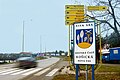 Municipality sign (November 2006)
 -
 St. Ladislav's Church (November 2006)
 -
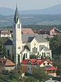 St. Ladislav's Church (September 2010)
 -
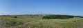 The panorama of the borough from the surrounding countryside (August 2015)
 -
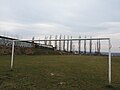 Football pitch in the borough (March 2014)


References edit
- ^ Mestská a obecná štatistika SR (urgently needs an updated statistics link for 2018) Archived 2007-04-27 at the Wayback Machine
External links edit
- Official website of the Košická Nová Ves borough
- Article on the Košická Nová Ves borough at Cassovia.sk
- Official website of Košice
48°43′54″N 21°18′03″E / 48.73167°N 21.30083°E