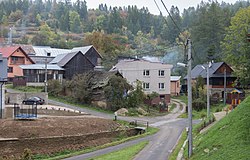
Hradisko is a village and municipality in Kežmarok District in the Prešov Region of north Slovakia.[5]
Hradisko | |
|---|---|
Municipality | |
 | |
| Coordinates: 49°03′25″N 20°31′20″E / 49.05694°N 20.52222°E | |
| Country | Slovakia |
| Region | Prešov |
| District | Kežmarok |
| Area | |
| • Total | 3.36[2] km2 (1.30[2] sq mi) |
| Elevation | 840[3] m (2,760[3] ft) |
| Population (2021) | |
| • Total | 94[1] |
| Time zone | UTC+1 (CET) |
| • Summer (DST) | UTC+2 (CEST) |
| Postal code | 059 71[3] |
| Area code | +421 52[3] |
| Car plate | KK |
| Website | http://obechradisko.webnode.sk/ |
History edit
In historical records the village was first mentioned in 1264. Hradisko had been known also by its German name Kuntschhöfchen.
Geography edit
The municipality lies at an altitude of 840 metres and covers an area of 2.635 km². It has a population of about 100 people.
See also edit
- List of municipalities and towns in Slovakia
- Ján Kellner, Slovak missionary to USSR, born in Hradisko, 1912.
References edit
- ^ "Počet obyvateľov podľa pohlavia - obce (ročne)". www.statistics.sk (in Slovak). Statistical Office of the Slovak Republic. 2022-03-31. Retrieved 2022-03-31.
- ^ a b "Hustota obyvateľstva - obce [om7014rr_ukaz: Rozloha (Štvorcový meter)]". www.statistics.sk (in Slovak). Statistical Office of the Slovak Republic. 2022-03-31. Retrieved 2022-03-31.
- ^ a b c d "Základná charakteristika". www.statistics.sk (in Slovak). Statistical Office of the Slovak Republic. 2015-04-17. Retrieved 2022-03-31.
- ^ a b "Hustota obyvateľstva - obce". www.statistics.sk (in Slovak). Statistical Office of the Slovak Republic. 2022-03-31. Retrieved 2022-03-31.
- ^ "Statistical Office of the Slovak Republic" (PDF). Výsledky SODB 2011. Štatistický úrad SR. Archived from the original (PDF) on 2013-10-12. Retrieved 9 August 2012.
Genealogical resources edit
The records for genealogical research are available at the state archive "Statny Archiv in Levoca, Slovakia"
- Roman Catholic church records (births/marriages/deaths): 1674-1900 (parish B)
- Lutheran church records (births/marriages/deaths): 1874-1944 (parish B)
External links edit
Wikimedia Commons has media related to Hradisko (Kežmarok District).
- https://web.archive.org/web/20160731201302/http://hradisko.e-obce.sk/
- Surnames of living people in Hradisko
