Henley Beach is a coastal suburb of Adelaide, South Australia in the City of Charles Sturt.
| Henley Beach Adelaide, South Australia | |||||||||||||||
|---|---|---|---|---|---|---|---|---|---|---|---|---|---|---|---|
 Henley Beach jetty | |||||||||||||||
| Population | 6,259 (SAL 2021)[1] | ||||||||||||||
| Established | c. 1860[2] | ||||||||||||||
| Postcode(s) | 5022[3] | ||||||||||||||
| Area | 2.5 km2 (1.0 sq mi) | ||||||||||||||
| Location | 9.7 km (6 mi) W of Adelaide city centre[3] | ||||||||||||||
| LGA(s) | City of Charles Sturt[4] | ||||||||||||||
| State electorate(s) | Colton (2011)[5] | ||||||||||||||
| Federal division(s) | Hindmarsh (2011)[6] | ||||||||||||||
| |||||||||||||||


History edit
Henley Beach draws its name from Henley-on-Thames, England,[7]where in 1186 it was hanlea which comes from either the celtic hen meaning old and ley referring to a place, or from Old English hean-leah meaning high meadow,[8] the land where it stands, sections 448 and 2080 in the Hundred of Yatala, was initially granted to Williams Bartley on November 1, 1850. Bartley later sold the land to James MacGeorge in August 1873. Subsequently, in May 1877, Arthur Harvey, Henry S. Anthony, and William P. Wicksteed acquired the land and proceeded to develop the town of Henley Beach.[9]
While admitted to be one of the finest in the colony, it has been somewhat neglected owing to the road not being made. The District Council and private enterprise, however, have overcome this...
— The Manning Index of South Australian History
Geography edit
Henley Beach lies between the suburbs of West Beach and Grange.
Demographics edit
The 2021 Census by the Australian Bureau of Statistics counted 6,259 persons in Henley Beach on census night. Of these, 49.4% were male and 50.6% were female.[11]
Aboriginal and Torres Strait Islander people make up 1.1% of the population. The most common ancestries in Woodville West were English (39.4%), Australian (31.7%), Irish (10.7%), Italian (10.6%) and Scottish (9.2%). The majority of residents (77.3%) are of Australian birth, with a further 5.7% identifying England as their country of origin. The most common religious affiliations in Woodville West were No Religion (43.3%), Catholic (26%), Anglican (7.9%), Eastern Orthodox (4.5%) and Uniting Church (4.3%).[11]
85.5% of the population stated they only speak English at home. The next most common languages were Greek (2.5%), Italian (1.9%) and Serbian, Afrikaans and Portuguese (0.5% each).[11]
Governance edit
Local government edit
Henley Beach is part of Henley Ward in the City of Charles Sturt local government area, being represented in that council by Kenzie Van den Nieuwelaar and Paul Sykes.[4] It was part of the Henley & Grange Council from 1915 until the merger with the City of Hindmarsh Woodville to create the City of Charles Sturt on 1 January 1997.[12][13]
State and federal edit
Henley Beach lies in the state electoral district of Colton[5] and the federal electoral division of Hindmarsh.[6] The suburb is represented in the South Australian House of Assembly by Paul Caica[5] and federally by Steve Georganas.
Schools edit
There are several schools in the suburb, including: Fulham Gardens Primary School, Fulham North Primary School, Henley High School, St Michael's College, Henley Beach Primary school, and Star of the Sea School
Parks edit
Henley Square is located behind Henley Jetty on the Esplanade. Other greenspace in the suburb is the Henley Grange Memorial Oval and John Mitchell Oval. Henley Beach extends the length of the suburb.
Transport edit
Henley Beach is serviced by Grange Road and Henley Beach Road, both connecting the suburb to Adelaide City Centre. Seaview Road runs along the coast.
Henley Beach is serviced by public transport run by the Adelaide Metro which provides bus services to the Adelaide city centre and Glenelg. The Grange railway line was extended to Henley Beach as the Henley Beach railway line in 1894 and the extension closed in 1957. There was a tram line from the city centre to Henley Beach. This was initially a horse-drawn tram, converted to electricity in the 1920s and ceased operation in the 1950s along with almost every other tram line in Adelaide.
Gallery edit
-
 Araucaria trees at Henley Beach
 -
 Henley Beach jetty
 -
 Cloudy summer weather
 -
 Sunset
 -
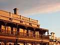 The Ramsgate
 -
 Henley Beach North


See also edit
References edit
- ^ Australian Bureau of Statistics (28 June 2022). "Henley Beach (suburb and locality)". Australian Census 2021 QuickStats. Retrieved 28 June 2022.
- ^ Manning, Geoffrey. "Place Names of South Australia". The Manning Index of South Australian History. State Library of South Australia. Retrieved 1 February 2012.
- ^ a b "Henley Beach, South Australia (Adelaide)". Postcodes-Australia. Postcodes-Australia.com. Retrieved 1 February 2012.
- ^ a b "City of Charles Sturt > Councillor contacts". City of Charles Sturt. Retrieved 19 February 2021.
- ^ a b c "Electoral Districts - Electoral District for the 2010 Election". Electoral Commission SA. Archived from the original on 22 August 2011. Retrieved 1 February 2012.
- ^ a b "Find my electorate: Hindmarsh". Australian Electoral Commission. Archived from the original on 30 September 2011. Retrieved 1 February 2012.
- ^ The Romance of Place Names of South Australia, By Geoffrey.H.Manning, 1986, p.89.
- ^ Manning's place Names of South Australia, By Geoffrey.H.Manning, 1990, p.147.
- ^ The Romance of Place Names of South Australia, By Geoffrey.H.Manning, 1986, p.89.
- ^ Manning's Place names of South Australia, By Geoffrey.H.Manning, 1990, p.146.
- ^ a b c Australian Bureau of Statistics (28 June 2022). "Henley Beach". 2021 Census QuickStats. Retrieved 4 November 2023.
- ^ Marsden, S (1977). A History of Woodville. Corporation of the City of Woodville. p. 3. ISBN 0-9599828-4-1.
- ^ "About Our City". The City of Charles Sturt. Retrieved 3 November 2015.
External links edit
- "City of Charles Sturt". Official website. City of Charles Sturt. Retrieved 1 February 2012.