General Carrera Lake (Chilean part, officially renamed in 1959)[2] or Lake Buenos Aires (Argentine part) is a deep lake located in Patagonia and shared by Argentina and Chile. Both names are internationally accepted, while the autochthonous name of the lake is Chelenko, which means "stormy waters" in Aonikenk.[3] Another historical name is Coluguape from Mapuche, a derivative of this name is applied to Colhué Huapí Lake after Argentine explorer Francisco Moreno reached this lake in 1876 conflating it with Coluguape (General Carrera Lake).[4]
| General Carrera Lake | |
|---|---|
| Buenos Aires Lake Lake Buenos Aires | |
 | |
General Carrera Lake in the Aysén Region | |
 General Carrera Lake | |
| Location | Lago Buenos Aires Department, Santa Cruz Province, Argentina / General Carrera Province, Aysén del General Carlos Ibáñez del Campo Region, Chile, in Patagonia |
| Coordinates | 46°26′15″S 71°42′54″W / 46.43750°S 71.71500°W[1] |
| Type | Moraine dammed |
| Primary inflows | Soler, Los Antiguos, Jeinemeni, Ibáñez, San Martín, Delta |
| Primary outflows | Bertrand Lake and then Baker River (Pacific Ocean) Deseado River (Atlantic Ocean) |
| Catchment area | 14,861 km2 (5,738 sq mi) |
| Basin countries | Argentina, Chile |
| Surface area | 1,850 km2 (710 sq mi) |
| Average depth | 400 m (1,300 ft) |
| Max. depth | 586 m (1,923 ft) |
| Water volume | 740 km3 (180 cu mi) |
| Shore length1 | 707 km (439 mi) |
| Surface elevation | 217 m (712 ft) |
| Frozen | never |
| Settlements | Chile Chico, Puerto Ingeniero Ibáñez, Puerto Guadal, Los Antiguos |
| References | [1] |
 | |
| 1 Shore length is not a well-defined measure. | |
.png)
The lake is of glacial origin and is surrounded by the Andes mountain range. The lake drains to the Pacific Ocean on the west through the Baker River. During the last glaciation the lake drained to the Atlantic through Deseado River.[4]
The weather in this area of Chile and Argentina is generally cold and humid. But the lake itself has a sunny microclimate, a weather pattern enjoyed by the few settlements along the lake, such as Puerto Guadal, Fachinal, Mallín Grande, Puerto Murta, Puerto Río Tranquilo, Puerto Sánchez, Puerto Ingeniero Ibáñez and Chile Chico in Chile, and Los Antiguos and Perito Moreno in Argentina.
The area near the coast of the lake was first inhabited by criollos and European immigrants between 1900 and 1925. In 1971 and 1991, eruptions of the Hudson Volcano severely affected the local economy, especially that of sheep farming. A car ferry operates between Puerto Ingeniero Ibáñez and Chile Chico in the Chilean sector of the lake. The lake is known as a trout and salmon fishing destination.
Area edit
The lake has a surface of 1,850 km2 (710 sq mi) of which 970 square kilometres (370 sq mi) are in the Chilean Aysén del General Carlos Ibáñez del Campo Region, and 880 square kilometres (340 sq mi) in the Argentine Santa Cruz Province, making it the biggest lake in Chile, and the fourth largest in Argentina. In its western basin, Lake Gen. Carrera has 586 m (1,923 ft) maximum depth.[5]
Geology edit
The lake occupies a continental-scale graben formed by SWS-ENE normal faults that have resulted in down-dropping the bottom of the lake to 350 meters (1,150 ft) below mean sea level.[6] Preservation of younger lithostratigraphic units within the graben form reverse stratigraphy with older units exposed at higher topographic elevations to the south. The graben channeled mountain glaciers which formed terminal moraine helping to modify the present-day shape of the lake. The tectonic activity that formed the depression can be inferred to subduction of the triple joint that has occurred over the past 20 million years, as indicated by ripple marks in volcaniclastic sediments observed along the southern shoreline. There is some speculation on whether the tectonics and crustal heat flow in the lake area are influenced by the asthenospheric window that exists beneath the crust in this region of Patagonia.[7]
The Marble Caves, Marble Chapel, and Marble Cathedral are unusual geological formations located on the shoreline midway along the lake's length. They represent a group of caverns, columns, and tunnels formed in monoliths of marble. The Marble Caves have been formed by wave action over the last 6,200 years.[8]
Gallery edit
-
 SRTM-Topography of the Chilean zone
 -
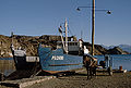 Boat near Chile Chico in Chile
 -
 Map of the Chilean zone
 -


References edit
- ^ a b Earth Info, earth-info.nga.mil webpage: "GNS: Country Files". Archived from the original on 2012-05-04. Retrieved 2010-06-27.
- ^ "Ley N.º 13.375: Crea y fija los limites de los departamentos de Palena, Aysén, Coyhaique y Chile Chico y las de sus respectivas comunas-subdelegaciones". Ministerio del Interior de Chile. 1959-09-09.
- ^ Prudencio Vergara, Guillermo (2019-05-06). "Una "fiebre del oro" junto al mayor lago de la Patagonia" [A "gold fever" along the major lake in Patagonia]. El País (in Spanish). Chile Chico. Retrieved 2021-12-29.
- ^ a b Melo, Walter D.; Scordo, Facundo; Perillo, Gerardo M. E.; Píccolo, M. Cintia (2017). "Identificación del lago "Coluguape" en la cartografía histórica (1775-1898): Su vinculación con el lago Buenos aires-General Carrera y el sistema lacustre Musters-Colhue Huapi" [Identification of the "Coluguape" lake in historical cartography (1775-1898): Its connection to the Buenos Aires-General Carrera lake and Musters- Colhue Huapi lake system]. Magallania (in Spanish). 45 (1): 15–33. doi:10.4067/S0718-22442017000100015. hdl:11336/27464.
- ^ Murdie et al. 1999, Geo-Marine Letters 18:315-320.
- ^ B. Scalabrino, et al., A morphotectonic analysis of central Patagonian Cordillera: Negative inversion of the Andean belt over a buried spreading center?, TECTONICS, VOL. 29, TC2010, doi:10.1029/2009TC002453, 2010
- ^ Lagabrielle, Yves; Suárez, Manuel; Rossello, Eduardo A.; Hérail, Gérard; Martinod, Joseph; Régnier, Marc; de la Cruz, Rita (2004). "Neogene to Quaternary tectonic evolution of the Patagonian Andes at the latitude of the Chile Triple Junction". Tectonophysics. 385 (1–4): 211–241. Bibcode:2004Tectp.385..211L. doi:10.1016/j.tecto.2004.04.023.
- ^ "The Marble Caves (Cavernas de Mármol)". Wondermondo. 2012-01-10.
External links edit
 Media related to General Carrera Lake at Wikimedia Commons