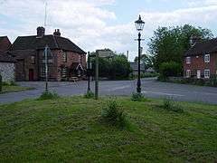
Finchdean is a rural hamlet in the East Hampshire district of Hampshire, England.[1][2] It lies on the Hampshire/West Sussex border, 1.7 miles (2.7 km) east of Horndean.
The origin of the place-name is from the Old English word finc and denu meaning valley of the finch (or of a man called Finc); the place-name appears as Finchesdene in 1167.[3] The village has a United Reformed Church in a building that was previously a stables before being converted to a chapel in 1830.[4]
The nearest railway station is 1.1 miles (1.8 km) south of the village, at Rowlands Castle (where according to the Post Office the 2011 Census population was included).
Finchdean has retained its village pound.
References edit
- ^ Ordnance Survey: Landranger map sheet 197 Chichester & the South Downs (Bognor Regis & Arundel) (Map). Ordnance Survey. 2013. ISBN 9780319231166.
- ^ "Ordnance Survey: 1:50,000 Scale Gazetteer" (csv (download)). www.ordnancesurvey.co.uk. Ordnance Survey. 1 January 2016. Retrieved 18 February 2016.
- ^ Mills, A.D. (2011) [first published 1991]. A Dictionary of British Place Names (First edition revised 2011 ed.). Oxford: Oxford University Press. p. 188. ISBN 9780199609086.
- ^ O’Brien, Charles; Bailey, Bruce; Pevsner, Nikolaus; Lloyd, David W. (2018). The Buildings of England Hampshire: South. Yale University Press. p. 359. ISBN 9780300225037.
External links edit
Media related to Finchdean at Wikimedia Commons

