
Original file (4,400 × 2,512 pixels, file size: 3.31 MB, MIME type: image/jpeg)
| This is a file from the Wikimedia Commons. Information from its description page there is shown below. Commons is a freely licensed media file repository. You can help. |
Summary
| Description |
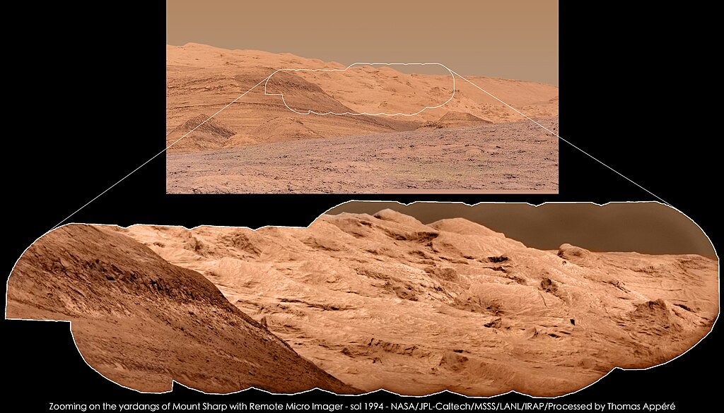
The Remote Micro Imager, part of ChemCam instrument, has imaged yardangs of Mount Sharp on sol 1994 at 12h00 local time. Yardangs are geologic structures carved by wind, observed in most Earth's deserts. Top image is a mosaic of 2 photos taken by the MastCam 100mm camera. Bottom image was obtained using the technique of pansharpening, i.e. the fusion of the RMI mosaic, providing details, and the MastCam 100mm image, providing colors. L'instrument Remote Micro Imager, qui fait partie de l'instrument ChemCam, a photographié les yardangs du Mont Sharp au sol 1994 à 12h00 heure locale.. Les yardangs sont des structures géologiques creusées par le vent, observées dans la plupart des déserts terrestres. L'image du haut est une mosaïque de 6 images acquises par la caméra MastCam 100 mm. L'image du bas a été obtenue grâce à la technique du "pansharpening", c'est-à-dire la fusion de la mosaïque RMI, qui fournit les détails, avec l'image MastCam 100 mm, qui apporte les couleurs. |
| Date | |
| Source | Zooming on the yardangs of Mount Sharp with Remote Micro Imager - sol 1994 |
| Author | Thomas Appéré from Saint-Avé, France |
Licensing
- You are free:
- to share – to copy, distribute and transmit the work
- to remix – to adapt the work
- Under the following conditions:
- attribution – You must give appropriate credit, provide a link to the license, and indicate if changes were made. You may do so in any reasonable manner, but not in any way that suggests the licensor endorses you or your use.
- share alike – If you remix, transform, or build upon the material, you must distribute your contributions under the same or compatible license as the original.
| This image was originally posted to Flickr by Thomas Appéré at https://flickr.com/photos/105035663@N07/40344654384 (archive). It was reviewed on 3 July 2018 by FlickreviewR 2 and was confirmed to be licensed under the terms of the cc-by-sa-2.0. |
File history
Click on a date/time to view the file as it appeared at that time.
| Date/Time | Thumbnail | Dimensions | User | Comment | |
|---|---|---|---|---|---|
| current | 17:50, 3 July 2018 | | 4,400 × 2,512 (3.31 MB) | Tillman | Transferred from Flickr via #flickr2commons |
File usage
Global file usage
The following other wikis use this file:
- Usage on zh.wikipedia.org