Size of this preview: 800 × 332 pixels. Other resolutions: 320 × 133 pixels | 917 × 380 pixels.
Original file (917 × 380 pixels, file size: 33 KB, MIME type: image/jpeg)
| This is a file from the Wikimedia Commons. Information from its description page there is shown below. Commons is a freely licensed media file repository. You can help. |

|
This file has been superseded by Earthlights dmsp.jpg. It is recommended to use the other file. Please note that deleting superseded images requires consent.
|
| Description |
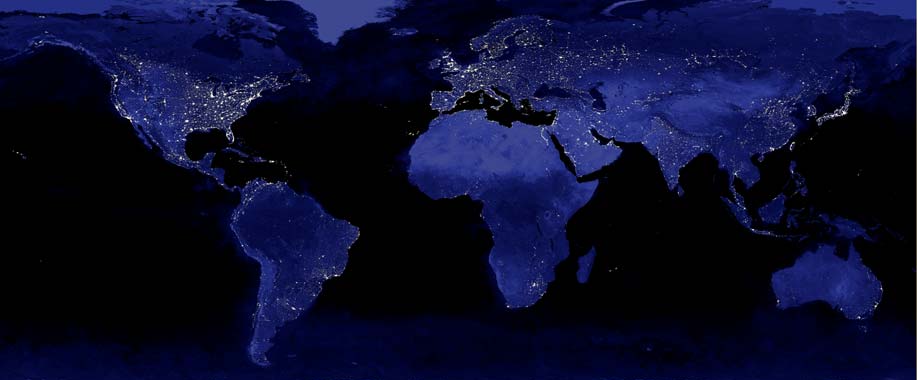
English: The image shows the urbanization of the world's cities through the use of the DMSP satellite system. This image of Earth's city lights was created with data from the Defense Meteorological Satellite Program (DMSP) Operational Linescan System (OLS). Originally designed to view clouds by moonlight, the OLS is also used to map the locations of permanent lights on the Earth's surface. The brightest areas of the Earth are the most urbanized, but not necessarily the most populated. (Compare western Europe with China and India.) Cities tend to grow along coastlines and transportation networks. The United States interstate highway system appears as a lattice connecting the brighter dots of city centers. In Russia, the Trans-Siberian railroad is a thin line stretching from Moscow through the center of Asia to Vladivostok. The Nile River, from the Aswan Dam to the Mediterranean Sea, is another bright thread through an otherwise dark region. Even more than 100 years after the invention of the electric light, some regions remain thinly populated and unlit. Antarctica is entirely dark. The interior jungles of Africa and South America are mostly dark, but lights are beginning to appear there. Deserts in Africa, Arabia, Australia, Mongolia, and the United States are poorly lit as well (except along the coast), along with the boreal forests of Canada and Russia, and the great mountains of the Himalaya. |
||
| Date | |||
| Source | Imagery by NASA and/or the US Geological Survey. Processed by Terra Prints Inc. | ||
| Author |
Data courtesy Marc Imhoff of NASA GSFC and Christopher Elvidge of NOAA NGDC. |
||
| Permission (Reusing this file) |
Own work, share alike, attribution required (Creative Commons CC-BY-SA-2.5) |
||
| Other versions |
|
.jpg)
I, the copyright holder of this work, hereby publish it under the following license:
This file is licensed under the Creative Commons Attribution-Share Alike 2.5 Generic license.
- You are free:
- to share – to copy, distribute and transmit the work
- to remix – to adapt the work
- Under the following conditions:
- attribution – You must give appropriate credit, provide a link to the license, and indicate if changes were made. You may do so in any reasonable manner, but not in any way that suggests the licensor endorses you or your use.
- share alike – If you remix, transform, or build upon the material, you must distribute your contributions under the same or compatible license as the original.
File history
Click on a date/time to view the file as it appeared at that time.
| Date/Time | Thumbnail | Dimensions | User | Comment | |
|---|---|---|---|---|---|
| current | 20:09, 22 February 2009 | | 917 × 380 (33 KB) | Cropbot | upload cropped version, operated by User:Finavon. Summary: caption/border cropped |
| 03:37, 22 October 2006 |  | 1,000 × 500 (46 KB) | Rolandc73 | {{Information |Description=Imagery by NASA and/or the US Geological Survey. Processed by Terra Prints Inc. The image shows the urbanization of the world's cities through the use of the DMSP satellite system. This image of Earth's city lights was created w |
File usage
The following pages on the English Wikipedia use this file (pages on other projects are not listed):
- User:NinaOdell/My sandbox
- User talk:Bearly541/Archive3
- User talk:Herostratus/Archive 2
- User talk:Itsmejudith/Archive 3
- User talk:Iwazaki/Archive 1
- User talk:Jimbo Wales/Archive 15
- User talk:Just H/Archive 2
- User talk:Khoikhoi/Archive 23
- User talk:ProveIt
- User talk:Renamed user 5417514488/archive 8
- User talk:ReverendG/Archive
- User talk:Sam/Archive 7
- User talk:The Transhumanist/Archive 2
- User talk:Tonywalton/Dec-2006
- Wikipedia talk:WikiProject Religion/Archive 2
Global file usage
The following other wikis use this file:
- Usage on nl.wikipedia.org