
Size of this preview: 600 × 600 pixels. Other resolutions: 240 × 240 pixels | 480 × 480 pixels | 768 × 768 pixels | 1,024 × 1,024 pixels | 2,300 × 2,300 pixels.
Original file (2,300 × 2,300 pixels, file size: 11.76 MB, MIME type: image/png)
| This is a file from the Wikimedia Commons. Information from its description page there is shown below. Commons is a freely licensed media file repository. You can help. |
Summary
| Description |
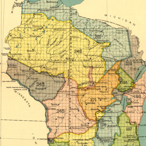
English: Map of lands in present-day Wisconsin ceded to the United States by Ojibwe (242), Dakota (243) and Winnebago leaders (245) in land cession treaties signed in 1837 |
| Date | |
| Source |
Indian Land Cessions in the United States, 1784-1894 United States Serial Set, Number 4015 |
| Author | Charles C. Royce |
Licensing
| This work is from the Library of Congress. According to the library, there are no known copyright restrictions on the use of this work. |  |
File history
Click on a date/time to view the file as it appeared at that time.
| Date/Time | Thumbnail | Dimensions | User | Comment | |
|---|---|---|---|---|---|
| current | 17:51, 24 June 2021 | | 2,300 × 2,300 (11.76 MB) | Cielquiparle | Uploaded a work by Charles C. Royce from Indian Land Cessions in the United States, 1784-1894 United States Serial Set, Number 4015 with UploadWizard |
File usage
The following pages on the English Wikipedia use this file (pages on other projects are not listed):