Size of this preview: 800 × 463 pixels. Other resolutions: 320 × 185 pixels | 640 × 370 pixels | 840 × 486 pixels.
Original file (840 × 486 pixels, file size: 144 KB, MIME type: image/jpeg)
| This is a file from the Wikimedia Commons. Information from its description page there is shown below. Commons is a freely licensed media file repository. You can help. |
Summary
| Description |
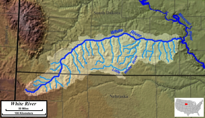
English: Map of the course, watershed, and tributaries of the White River in the US states of Nebraska and South Dakota. |
| Date | |
| Source | Base map used was taken from the National Atlas, remaining work was done by the uploader. Drainage basin maps used as a reference were from this site from the United States Geological Survey. |
| Author | Jon Platek |
Licensing
I, the copyright holder of this work, hereby publish it under the following licenses:
This file is licensed under the Creative Commons Attribution-Share Alike 3.0 Unported license.
- You are free:
- to share – to copy, distribute and transmit the work
- to remix – to adapt the work
- Under the following conditions:
- attribution – You must give appropriate credit, provide a link to the license, and indicate if changes were made. You may do so in any reasonable manner, but not in any way that suggests the licensor endorses you or your use.
- share alike – If you remix, transform, or build upon the material, you must distribute your contributions under the same or compatible license as the original.

|
Permission is granted to copy, distribute and/or modify this document under the terms of the GNU Free Documentation License, Version 1.2 or any later version published by the Free Software Foundation; with no Invariant Sections, no Front-Cover Texts, and no Back-Cover Texts. A copy of the license is included in the section entitled GNU Free Documentation License. |
You may select the license of your choice.
File history
Click on a date/time to view the file as it appeared at that time.
| Date/Time | Thumbnail | Dimensions | User | Comment | |
|---|---|---|---|---|---|
| current | 03:43, 8 February 2010 | | 840 × 486 (144 KB) | AlexiusHoratius~commonswiki | {{Information |Description={{en|1=Map of the course, watershed, and tributaries of the White River in the US states of Nebraska and South Dakota.}} |Source=Base map used was taken from the [http://www.nationalatlas.gov/natlas/Natlasstart.asp National Atla |
File usage
The following pages on the English Wikipedia use this file (pages on other projects are not listed):
Global file usage
The following other wikis use this file:
- Usage on bg.wikipedia.org
- Usage on de.wikipedia.org
- Usage on es.wikipedia.org
- Usage on fa.wikipedia.org
- Usage on lt.wikipedia.org
- Usage on pl.wikipedia.org
- Usage on sr.wikipedia.org
- Usage on www.wikidata.org
- Usage on zh.wikipedia.org