File:Virginia October 1864 Winchester - Mt Jackson.png

Original file(611 × 650 pixels, file size: 787 KB, MIME type: image/png)

Summary

Description
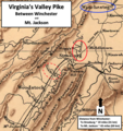
English: Valley Pike region in Virginia surrounding the area where the Battle of Cedar Creek was fought on October 19, 1864, in the American Civil War
Date
Source This is a crop of a 1912 map named "Sifton, Praed's new map of Virginia and Maryland to illustrate the campaigns of 1861 to 1864." from the U.S. Library of Congress here.
Author Sifton, Praed & Company, Ltd. with labels and circles added by TwoScarsUp based on the following books: The Guns of Cedar Creek by Thomas A. Lewis, The War in the East from Gettysburg to Appomattox by Stephen Z. Starr, and From Winchester to Cedar Creek by Jeffry D. Wert.

Licensing

Public domain
This work is in the public domain in the United States because it was published (or registered with the U.S. Copyright Office) before January 1, 1929.

Public domain works must be out of copyright in both the United States and in the source country of the work in order to be hosted on the Commons. If the work is not a U.S. work, the file must have an additional copyright tag indicating the copyright status in the source country.
Note: This tag should not be used for sound recordings.PD-1923Public domain in the United States//commons.wikimedia.org/wiki/File:Virginia_October_1864_Winchester_-_Mt_Jackson.png

Captions

Valley Pike region between Winchester and Mt. Jackson, Virginia

Items portrayed in this file

depicts

File history

Click on a date/time to view the file as it appeared at that time.

Date/TimeThumbnailDimensionsUserComment
current21:40, 4 January 2022Thumbnail for version as of 21:40, 4 January 2022611 × 650 (787 KB)TwoScarsUpUploaded a work by Sifton, Praed & Company, Ltd. with labels and circles added by TwoScarsUp based on the following books: The Guns of Cedar Creek by Thomas A. Lewis, The War in the East from Gettysburg to Appomattox by Stephen Z. Starr, and From Winchester to Cedar Creek by Jeffry D. Wert. from This is a crop of a 1912 map named "Sifton, Praed's new map of Virginia and Maryland to illustrate the campaigns of 1861 to 1864." from the U.S. Library of Congress [https://www.loc.gov/item/99448878/...
The following pages on the English Wikipedia use this file (pages on other projects are not listed):