No higher resolution available.
View_over_the_Sirhowy_Valley_-_geograph.org.uk_-_1570835.jpg (640 × 480 pixels, file size: 148 KB, MIME type: image/jpeg)
| This is a file from the Wikimedia Commons. Information from its description page there is shown below. Commons is a freely licensed media file repository. You can help. |
Summary
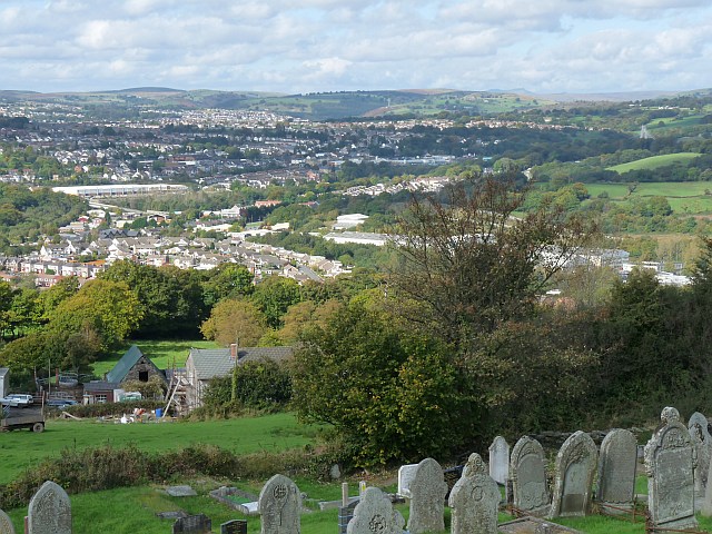
| Description |
English: View over the Sirhowy Valley. Taken from the churchyard of New Bethel Church, Mynyddislwyn 1570832.
Overlooking Ty-Fry Farm, Cwmnantyrodyn, Pontllanfraith and Blackwood with the tower of Chartist Bridge https://www.geograph.org.uk/photo/764929 visible at the upper right. On the horizon are the peaks of the Brecon Beacons https://www.geograph.org.uk/photo/18832 . |
| Date | |
| Source | From geograph.org.uk |
| Author | Robin Drayton |
| Attribution (required by the license) | Robin Drayton / View over the Sirhowy Valley / |
| Camera location | | View this and other nearby images on: OpenStreetMap |
|---|
_heading:315.00&language=en)
| Object location | | View this and other nearby images on: OpenStreetMap |
|---|
_heading:315.00&language=en)
Licensing

|
This image was taken from the Geograph project collection. See this photograph's page on the Geograph website for the photographer's contact details. The copyright on this image is owned by Robin Drayton and is licensed for reuse under the Creative Commons Attribution-ShareAlike 2.0 license.
|
This file is licensed under the Creative Commons Attribution-Share Alike 2.0 Generic license.
Attribution: Robin Drayton
- You are free:
- to share – to copy, distribute and transmit the work
- to remix – to adapt the work
- Under the following conditions:
- attribution – You must give appropriate credit, provide a link to the license, and indicate if changes were made. You may do so in any reasonable manner, but not in any way that suggests the licensor endorses you or your use.
- share alike – If you remix, transform, or build upon the material, you must distribute your contributions under the same or compatible license as the original.
File history
Click on a date/time to view the file as it appeared at that time.
| Date/Time | Thumbnail | Dimensions | User | Comment | |
|---|---|---|---|---|---|
| current | 22:05, 3 March 2011 | | 640 × 480 (148 KB) | GeographBot | == {{int:filedesc}} == {{Information |description={{en|1=View over the Sirhowy Valley Taken from the churchyard of New Bethel Church, Mynyddislwyn http://www.geograph.org.uk/photo/1570832 . Overlooking Ty-Fry Farm, Cwmnantyrodyn, Pontllanfraith and Black |
File usage
The following pages on the English Wikipedia use this file (pages on other projects are not listed):