
Size of this PNG preview of this SVG file: 800 × 553 pixels. Other resolutions: 320 × 221 pixels | 640 × 442 pixels | 1,024 × 708 pixels | 1,280 × 884 pixels | 2,560 × 1,769 pixels | 6,821 × 4,713 pixels.
Original file (SVG file, nominally 6,821 × 4,713 pixels, file size: 696 KB)
| This is a file from the Wikimedia Commons. Information from its description page there is shown below. Commons is a freely licensed media file repository. You can help. |
Summary
| Description |
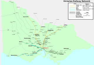
English: Map of the railway network of Victoria, Australia for 2014. Excludes suburban network as seen in :Image:Melbourne_railways_map.gif, as well as V/Line passenger stations close to Geelong and Ballarat. Lines are grouped by V/Line Interurban / Intercity classifications, and region groupings. Freight and tourist railway lines also included. Track gauge is as well. |
| Date | |
| Source | Own work |
| Author | Marcus Wong Wongm |
| Other versions |
 |
Licensing
I, the copyright holder of this work, hereby publish it under the following license:
This file is licensed under the Creative Commons Attribution-Share Alike 4.0 International license.
- You are free:
- to share – to copy, distribute and transmit the work
- to remix – to adapt the work
- Under the following conditions:
- attribution – You must give appropriate credit, provide a link to the license, and indicate if changes were made. You may do so in any reasonable manner, but not in any way that suggests the licensor endorses you or your use.
- share alike – If you remix, transform, or build upon the material, you must distribute your contributions under the same or compatible license as the original.
File history
Click on a date/time to view the file as it appeared at that time.
| Date/Time | Thumbnail | Dimensions | User | Comment | |
|---|---|---|---|---|---|
| current | 05:24, 28 April 2022 | | 6,821 × 4,713 (696 KB) | Wongm | Fix typo in 'Toolamba' |
| 09:39, 23 December 2014 |  | 6,821 × 4,713 (696 KB) | Wongm | Update map for V/Line services to Maryborough. | |
| 09:23, 23 December 2014 |  | 6,821 × 4,713 (691 KB) | Wongm | Fix issues with black boxes around text, as well as the mess around the state outline. | |
| 09:03, 23 December 2014 |  | 7,021 × 4,844 (959 KB) | Wongm | Fix issues with SVG canvas size | |
| 08:59, 23 December 2014 |  | 744 × 1,052 (969 KB) | Wongm | {{Information |Description={{en|Map of the railway network of Victoria, Australia for 2007. Excludes suburban network as seen in [[:en::Image:Melbourne_railways_map.gif|:Image:Melbourne_railways_map.gif]]. Lines are grouped by V/Line Int... |
File usage
The following pages on the English Wikipedia use this file (pages on other projects are not listed):
Global file usage
The following other wikis use this file: