
Size of this preview: 480 × 600 pixels. Other resolutions: 192 × 240 pixels | 384 × 480 pixels | 614 × 768 pixels | 819 × 1,024 pixels | 1,638 × 2,048 pixels | 6,400 × 8,000 pixels.
Original file (6,400 × 8,000 pixels, file size: 6.8 MB, MIME type: image/jpeg)
| This is a file from the Wikimedia Commons. Information from its description page there is shown below. Commons is a freely licensed media file repository. You can help. |
Summary
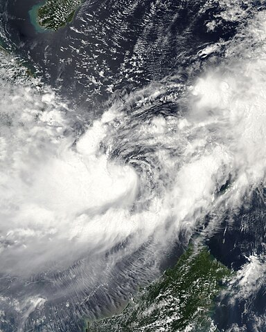
| Description | This image of Tropical Storm Vicente was captured by the MODIS instrument on NASA's Aqua satellite at 0546 UTC when it was located in the South China Sea. The maximum sustained winds for the storm were 30 knots (10-minute average) and the minimum pressure was about 1000 mb. | ||||||
| Date | |||||||
| Source | http://www.nrlmry.navy.mil/tc_pages/tc_home.html | ||||||
| Author | Naval Research Laboratory | ||||||
| Permission (Reusing this file) |
|
||||||

File history
Click on a date/time to view the file as it appeared at that time.
| Date/Time | Thumbnail | Dimensions | User | Comment | |
|---|---|---|---|---|---|
| current | 15:55, 29 September 2020 | | 6,400 × 8,000 (6.8 MB) | FleurDeOdile | dimensions |
| 04:26, 13 December 2017 |  | 6,706 × 6,562 (3.98 MB) | TheAustinMan | Color and grid-less | |
| 16:56, 14 September 2006 |  | 3,875 × 3,875 (1.63 MB) | Good kitty | == Summary == {{Information |Description=This image of Tropical Storm Vicente was captured by the MODIS instrument on NASA's Aqua satellite at 0546 UTC when it was located in the South China Sea. The maximum sustained winds for the storm were 30 knots (10 |
File usage
The following pages on the English Wikipedia use this file (pages on other projects are not listed):
Global file usage
The following other wikis use this file:
- Usage on es.wikipedia.org
- Usage on ja.wikipedia.org
- Usage on ko.wikipedia.org
- Usage on pt.wikipedia.org
- Usage on vi.wikipedia.org
- Usage on zh.wikipedia.org