.svg)
.svg&action=edit&redlink=1)

Size of this PNG preview of this SVG file: 800 × 406 pixels. Other resolutions: 320 × 162 pixels | 640 × 325 pixels | 1,024 × 520 pixels | 1,280 × 650 pixels | 2,560 × 1,300 pixels | 2,754 × 1,398 pixels.
Original file (SVG file, nominally 2,754 × 1,398 pixels, file size: 1.05 MB)
| This is a file from the Wikimedia Commons. Information from its description page there is shown below. Commons is a freely licensed media file repository. You can help. |
.svg)
Summary
| Description |
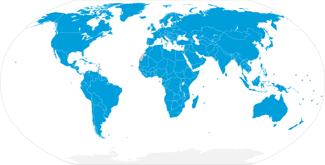
English: Map showing the UN member states
UN Member States UN Observer States Non-Member States and Non-Self-Governing Territories Antarctica (international territory)
Español: Mapa mostrando los países miembros de la ONU
Estados miembros de la ONU Países observadores de la ONU Estados no miembros y territorios no autónomos Antártida (territorio internacional) |
| Date | |
| Source |
Own work based on:
|
| Author | M.Bitton |
| Other versions |
United Nations (Member States and Territories).svg, with dots for territories and non-member states Meant to replace United Nations Members.svg, which is buggy |
| SVG development | This world map was created with a text editor. |
.svg)
Licensing
I, the copyright holder of this work, hereby publish it under the following license:
This file is licensed under the Creative Commons Attribution-Share Alike 4.0 International license.
- You are free:
- to share – to copy, distribute and transmit the work
- to remix – to adapt the work
- Under the following conditions:
- attribution – You must give appropriate credit, provide a link to the license, and indicate if changes were made. You may do so in any reasonable manner, but not in any way that suggests the licensor endorses you or your use.
- share alike – If you remix, transform, or build upon the material, you must distribute your contributions under the same or compatible license as the original.
File history
Click on a date/time to view the file as it appeared at that time.
.svg&dir=prev)
.svg&offset=20220704060959)
.svg&offset=&limit=20)
.svg&offset=&limit=50)
.svg&offset=&limit=100)
.svg&offset=&limit=250)
.svg&offset=&limit=500)
| Date/Time | Thumbnail | Dimensions | User | Comment | |
|---|---|---|---|---|---|
| current | 02:38, 9 July 2022 | | 2,754 × 1,398 (1.05 MB) | Kwamikagami | comment out mouseover names of Kosovo, N.Cyprus, Somaliland etc., which are not rec by UN |
| 16:52, 6 July 2022 |  | 2,754 × 1,398 (1.05 MB) | M.Bitton | Different colour for the observer States | |
| 00:20, 5 July 2022 |  | 2,754 × 1,398 (1.05 MB) | M.Bitton | Optimized for readability | |
| 22:09, 4 July 2022 |  | 2,754 × 1,398 (1.05 MB) | Kwamikagami | m | |
| 21:53, 4 July 2022 |  | 2,754 × 1,398 (1.05 MB) | Kwamikagami | touch up grey > blue, consistent circle size | |
| 18:15, 4 July 2022 |  | 2,754 × 1,398 (1.05 MB) | M.Bitton | Reverted to version as of 14:06, 4 July 2022 (UTC): there really is no need to change the base map | |
| 18:02, 4 July 2022 |  | 2,756 × 1,399 (814 KB) | Newfraferz87 | Using more compact & customizable template from here, will this work better? | |
| 14:06, 4 July 2022 |  | 2,754 × 1,398 (1.05 MB) | M.Bitton | Optimized for readability | |
| 13:41, 4 July 2022 |  | 2,754 × 1,398 (1.05 MB) | M.Bitton | Updated | |
| 06:09, 4 July 2022 |  | 2,754 × 1,398 (1.05 MB) | Kwamikagami | Use national names for decolonized areas (Puerto Rico, Guadeloupe, Bonaire, etc.) |
File usage
The following pages on the English Wikipedia use this file (pages on other projects are not listed):
Global file usage
The following other wikis use this file:
- Usage on ar.wikipedia.org
- Usage on es.wikipedia.org
- Usage on fr.wikipedia.org
- Usage on mai.wikipedia.org
- Usage on mn.wikipedia.org
- Usage on nds-nl.wikipedia.org
- Usage on pl.wiktionary.org
- Usage on pt.wikipedia.org
- Usage on so.wikipedia.org
- Usage on tr.wikipedia.org
- Usage on uk.wikipedia.org
.svg)