No higher resolution available.
Trementina2.jpg (403 × 267 pixels, file size: 22 KB, MIME type: image/jpeg)
| This is a file from the Wikimedia Commons. Information from its description page there is shown below. Commons is a freely licensed media file repository. You can help. |
Summary
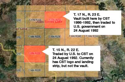
| Description |
English: Map showing land plots near Trementina, New Mexico. Made from PD government plot maps overlaid on PD government satellite map image-fix to older file |
| Date | 11 May 2006 (original upload date) |
| Source | Transferred from en.wikipedia to Commons by Cirt using CommonsHelper. |
| Author | Huntley Troth at English Wikipedia |
Licensing
| This work has been released into the public domain by its author, Huntley Troth at English Wikipedia. This applies worldwide. In some countries this may not be legally possible; if so: Huntley Troth grants anyone the right to use this work for any purpose, without any conditions, unless such conditions are required by law. |
Original upload log
The original description page was here. All following user names refer to en.wikipedia.
- 2006-05-11 10:09 Huntley Troth 403×267× (22890 bytes) Map showing land plots near Trementina, New Mexico. Made from PD government plot maps overlaid on PD goverment satellite map image-fix to older file
File history
Click on a date/time to view the file as it appeared at that time.
| Date/Time | Thumbnail | Dimensions | User | Comment | |
|---|---|---|---|---|---|
| current | 16:00, 21 May 2011 | | 403 × 267 (22 KB) | File Upload Bot (Magnus Manske) | {{BotMoveToCommons|en.wikipedia|year={{subst:CURRENTYEAR}}|month={{subst:CURRENTMONTHNAME}}|day={{subst:CURRENTDAY}}}} {{Information |Description={{en|Map showing land plots near Trementina, New Mexico. Made from PD government plot maps overlaid on PD go |
File usage
The following pages on the English Wikipedia use this file (pages on other projects are not listed):