
Original file (480 × 640 pixels, file size: 95 KB, MIME type: image/jpeg)
| This is a file from the Wikimedia Commons. Information from its description page there is shown below. Commons is a freely licensed media file repository. You can help. |
Summary
| Description |
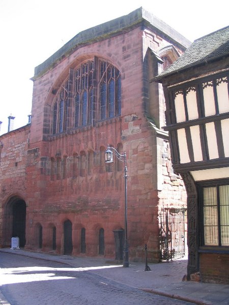
English: St Mary's guildhall, Bayley Lane, Coventry. A grade I listed building. To the right is the corner of the decorated timber framed building, 22 Bayley Lane. In front of the hall, to the left of the modern 'old style' street light, is a stand pump housing.
St Mary's guildhall was built in 1342 for the Merchants' Guild. The large window, visible here, was altered to accommodate the hanging of a tapestry believed to depict Henry VI and Margaret of Anjou, which was in place in 1499 and still hangs in the place for which it was designed. The hall has had a varied history: from 1421 to 1863 it housed council meetings; it served as the focus for the court of Henry VI during the 15th century Wars of the Roses; during the Civil War period of the 17th century it was used as an armoury; in the 18th century it was used as a theatre, with performances by Sarah Siddons; in 1860 it was put to use as a soup kitchen for ribbon weavers thrown into hard times by the collapse of their trade; Caesar's Tower was damaged during WW2 and in the 21st century it has housed sessions by performers in the annual Coventry Jazz Festival. George Eliot used the great hall as inspiration for the location of the trial of Hetty Sorrel in her 1859 novel 'Adam Bede': "The midday light that fell on the close pavement of human heads was shed through a line of high pointed windows, variegated with the mellow tints of old painted glass. Grim dusty armour hung in high relief in front of the dark oaken gallery at the farther end, and under the broad arch of the great mullioned window opposite was spread a curtain of old tapestry, covered with dim melancholy figures, like a dozing indistinct dream of the past." |
| Date | |
| Source | From geograph.org.uk |
| Author | E Gammie |
| Attribution (required by the license) | E Gammie / St Mary's guildhall, Bayley Lane / |
| Camera location | | View this and other nearby images on: OpenStreetMap |
|---|
_heading:135.00&language=en)
| Object location | | View this and other nearby images on: OpenStreetMap |
|---|
_heading:135.00&language=en)
Licensing

|
This image was taken from the Geograph project collection. See this photograph's page on the Geograph website for the photographer's contact details. The copyright on this image is owned by E Gammie and is licensed for reuse under the Creative Commons Attribution-ShareAlike 2.0 license.
|
- You are free:
- to share – to copy, distribute and transmit the work
- to remix – to adapt the work
- Under the following conditions:
- attribution – You must give appropriate credit, provide a link to the license, and indicate if changes were made. You may do so in any reasonable manner, but not in any way that suggests the licensor endorses you or your use.
- share alike – If you remix, transform, or build upon the material, you must distribute your contributions under the same or compatible license as the original.
File history
Click on a date/time to view the file as it appeared at that time.
| Date/Time | Thumbnail | Dimensions | User | Comment | |
|---|---|---|---|---|---|
| current | 13:35, 21 February 2011 | | 480 × 640 (95 KB) | GeographBot | == {{int:filedesc}} == {{Information |description={{en|1=St Mary's guildhall, Bayley Lane A grade I listed building. To the right is the corner of the decorated timber framed building, 22 Bayley Lane. In front of the hall, to the left of the modern 'old |